Yachats River facts for kids
Quick facts for kids Yachats River |
|
|---|---|

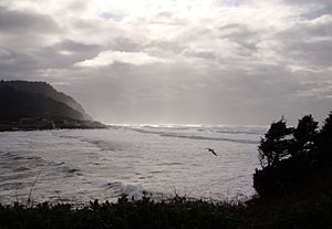
Mouth of the Yachats River
|
|
| Country | United States |
| Physical characteristics | |
| Main source | Central Oregon Coast Range 1,200 ft (370 m) |
| River mouth | Pacific Ocean sea level |
| Length | 15 mi (24 km) |
| Basin features | |
| Basin size | 44 sq mi (110 km2) |
The Yachats River (pronounced YAH-hahts) is a small river located on the central coast of Oregon. It flows into the Pacific Ocean and is about 60 miles (100 km) west-north-west of Eugene. The name "Yachats" comes from a native word that means at the foot of the mountain.
Contents
Journey of the Yachats River
The Yachats River starts its journey about 12 miles (19 km) east-south-east of the town of Yachats, Oregon. It begins in a thick forest, high up in the mountains.
From Mountains to Ocean
The river first flows north for about three miles (5 km). Along the way, it is joined by smaller streams like Grass Creek and School Fork. After these join, the river turns west.
More creeks, such as Keller, Stump, and Neiglick, add their water to the Yachats River. As it gets closer to the ocean, the riverbed becomes wider and the water flows much slower. It then meanders, or winds, its way westward until it reaches the Pacific Ocean.
Where the River Meets the Sea
At the mouth of the river, where it meets the ocean, there is a sandy and stony beach. This area is often very shallow. Because of this, the ocean's tides can change how long the river appears to be by as much as a mile!
River Branches and Streams
Many smaller streams and creeks flow into the Yachats River, adding to its water. These are called tributaries.
Main Tributaries
Starting from where the river begins and moving towards the ocean, some of the important tributaries include:
- Grass Creek
- School Fork
- Keller Creek
- Stump Creek
- Neiglick Creek
- North Fork Yachats River
Other Creeks Joining the River
Further downstream, many other creeks also join the Yachats River. These include Axtell, Helms, Werner, Bend, Clear, Carlson, Dawson, Beamer, South Beamer, Marks, Reedy, and Salmon creeks. Each of these adds to the flow of the river as it makes its way to the sea.
 | Tommie Smith |
 | Simone Manuel |
 | Shani Davis |
 | Simone Biles |
 | Alice Coachman |

