Cloverdale, Oregon facts for kids
Quick facts for kids
Cloverdale, Oregon
|
|
|---|---|
|
Census-designated place (CDP)
|
|
 |
|

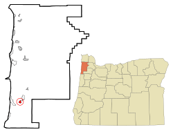
Location of Cloverdale, Oregon
|
|
| Country | United States |
| State | Oregon |
| County | Tillamook |
| Area | |
| • Total | 0.80 sq mi (2.08 km2) |
| • Land | 0.80 sq mi (2.08 km2) |
| • Water | 0.00 sq mi (0.00 km2) |
| Elevation | 23 ft (7 m) |
| Population
(2020)
|
|
| • Total | 267 |
| • Density | 332.92/sq mi (128.52/km2) |
| Time zone | UTC-8 (Pacific (PST)) |
| • Summer (DST) | UTC-7 (PDT) |
| ZIP code |
97112
|
| Area code(s) | 503 |
| FIPS code | 41-14200 |
| GNIS feature ID | 1139856 |
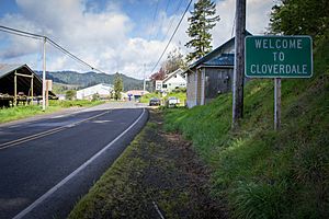
Cloverdale is a small community in Tillamook County, Oregon, United States. It's not an official city, but the United States Census Bureau counts it as a "census-designated place" (CDP). This means it's an area with people living in it that the government tracks for statistics. In 2020, about 267 people lived in Cloverdale.
Contents
History of Cloverdale
Cloverdale was started by a man named Charles Ray. He moved to Tillamook County around 1884. Charles Ray decided to name the area Cloverdale.
He built some important places for the community. These included a store, a hotel, a bank, and even a cheese factory. A post office was opened in Cloverdale in 1899, which helped the community grow.
Where is Cloverdale?
Cloverdale is a small area of land. According to the United States Census Bureau, it covers about 2.08 square kilometers (0.8 square miles). All of this area is land, with no large bodies of water inside its borders.
Weather in Cloverdale
Cloverdale has a special kind of weather called a warm-summer Mediterranean climate. This means that the summers are usually cool and dry. The winters are mild, but they get a lot of rain.
You can see more details about the weather in the table below:
| Climate data for Cloverdale 1991-2020 normals, extremes 1940- | |||||||||||||
|---|---|---|---|---|---|---|---|---|---|---|---|---|---|
| Month | Jan | Feb | Mar | Apr | May | Jun | Jul | Aug | Sep | Oct | Nov | Dec | Year |
| Record high °F (°C) | 69 (21) |
76 (24) |
80 (27) |
87 (31) |
90 (32) |
94 (34) |
95 (35) |
98 (37) |
98 (37) |
94 (34) |
80 (27) |
71 (22) |
98 (37) |
| Mean daily maximum °F (°C) | 51.9 (11.1) |
53.4 (11.9) |
54.8 (12.7) |
57.2 (14.0) |
61.5 (16.4) |
64.9 (18.3) |
69.3 (20.7) |
70.4 (21.3) |
69.2 (20.7) |
62.9 (17.2) |
56.0 (13.3) |
51.1 (10.6) |
60.2 (15.7) |
| Mean daily minimum °F (°C) | 39.8 (4.3) |
39.5 (4.2) |
40.4 (4.7) |
41.8 (5.4) |
45.8 (7.7) |
49.3 (9.6) |
51.7 (10.9) |
51.5 (10.8) |
49.5 (9.7) |
45.5 (7.5) |
42.0 (5.6) |
39.5 (4.2) |
44.7 (7.1) |
| Record low °F (°C) | 8 (−13) |
11 (−12) |
25 (−4) |
27 (−3) |
30 (−1) |
33 (1) |
36 (2) |
36 (2) |
33 (1) |
26 (−3) |
17 (−8) |
9 (−13) |
8 (−13) |
| Average precipitation inches (mm) | 11.36 (289) |
8.74 (222) |
8.84 (225) |
6.84 (174) |
4.26 (108) |
2.99 (76) |
0.76 (19) |
1.12 (28) |
2.98 (76) |
6.91 (176) |
12.24 (311) |
12.65 (321) |
79.69 (2,025) |
| Average snowfall inches (cm) | 0.3 (0.76) |
0.4 (1.0) |
0.2 (0.51) |
0.1 (0.25) |
0 (0) |
0 (0) |
0 (0) |
0 (0) |
0 (0) |
0 (0) |
trace | 0.2 (0.51) |
1.2 (3.03) |
| Average precipitation days | 18.1 | 15.1 | 18.5 | 16.2 | 11.3 | 8.9 | 3.9 | 4.3 | 7.0 | 12.7 | 17.7 | 18.3 | 152.0 |
| Average snowy days | 0.1 | 0.3 | 0.2 | 0.1 | 0 | 0 | 0 | 0 | 0 | 0 | 0.0 | 0.2 | 0.9 |
| Source: NOAA | |||||||||||||
Who Lives in Cloverdale?
| Historical population | |||
|---|---|---|---|
| Census | Pop. | %± | |
| 2020 | 267 | — | |
| U.S. Decennial Census | |||
In 2000, there were 242 people living in Cloverdale. These people lived in 93 different homes, and 70 of these were families. Most of the people living there were White (97.52%). A small number were African American (0.41%) or Native American (1.24%).
About 27% of the homes had children under 18 living there. Most homes (61.3%) were married couples living together.
The people in Cloverdale were of different ages. About 21.5% were under 18 years old. The median age was 44 years. This means half the people were younger than 44 and half were older.
See also
 In Spanish: Cloverdale (Oregón) para niños
 | John T. Biggers |
 | Thomas Blackshear |
 | Mark Bradford |
 | Beverly Buchanan |

