
Waldport, Oregon facts for kids
Quick facts for kids
Waldport, Oregon
|
|
|---|---|

Alsea Bay Bridge Interpretive Center in Waldport
|
|
| Motto(s):
Where the Forest Meets the Sea
|
|

Location in Oregon
|
|
| Country | United States |
| State | Oregon |
| County | Lincoln |
| Incorporated | 1911 |
| Area | |
| • Total | 2.94 sq mi (7.62 km2) |
| • Land | 2.71 sq mi (7.03 km2) |
| • Water | 0.23 sq mi (0.59 km2) |
| Elevation | 12 ft (3.7 m) |
| • Density | 828.36/sq mi (319.82/km2) |
| Time zone | UTC−08:00 (Pacific) |
| • Summer (DST) | UTC−07:00 (Pacific) |
| ZIP Code |
97394
|
| Area code(s) | 541 |
| FIPS code | 41-78000 |
| GNIS feature ID | 1151822 |
| Website | http://www.waldportoregon.gov |
Waldport is a city in Lincoln County, Oregon, in the United States. In 2010, about 2,033 people lived there. The city sits by the Alsea River and Alsea Bay. It is about 15 miles (24 km) south of Newport. It is also about 8 miles (13 km) north of Yachats.
Contents
History of Waldport
Settlement in Waldport started in 1879. David Ruble bought land from Lint Starr for $300. This land included the area now called "Old Town." Many early settlers came from Germany. One suggested name for the town was Waldport. "Wald" means forest or trees in German. "Port" refers to its closeness to the ocean. The town's name is quite special.
The town's map was officially recorded on September 9, 1885. By 1911, Waldport became an official city. It had about a dozen businesses and 150 people living there.
Early Inhabitants
The first people in this area were called the "Alsi" or "Alsea." The Coos tribe gave them this name. In their own language, they called themselves "Wusi" or "Wusitslum." Around 1780, the "Yakonan" people, who lived from Yaquina Bay to the Siuslaw River, were thought to be over 6,000 strong. The Alsea River and bay had many small villages.
By the time Lewis and Clark explored the area, their numbers had dropped to about 1,000. By 1910, only 29 remained at the Siletz reservation.
Camp Angel and World War II
Camp Angel was a Civilian Conservation Corps camp near Waldport. During World War II, it became a home for conscientious objectors. These were people who refused to fight in the war for moral or religious reasons. Many of them were involved in arts and creative activities.
Heaven's Gate Lecture
In September 1975, Marshall Applewhite and Bonnie Nettles gave a talk in Waldport. They spoke about UFOs to about 150 people. After this, some residents joined their group, Heaven's Gate. An investigation by the Oregon State Police found no laws were broken.
Geography and Climate
Where is Waldport?
According to the United States Census Bureau, Waldport covers about 3.02 square miles (7.82 square kilometers). Of this, 2.77 square miles (7.17 square kilometers) is land. The remaining 0.25 square miles (0.65 square kilometers) is water.
Waldport's Weather
Waldport has a warm-summer Mediterranean climate. This means it has warm, but not hot, summers. Summers also have some rainy days. No average monthly temperatures go above 70.4°F (21.3°C). This type of climate is similar to parts of Ireland or British Columbia in Canada.
Winters are cool and get a lot of rain. Summers are warm and dry. They have partly cloudy skies and some light rain. Snow is rare in Waldport during winter.
- Average December temperatures: High of 53.0°F (11.7°C), low of 39.0°F (3.9°C).
- Average August temperatures: High of 70.4°F (21.3°C), low of 61.5°F (16.4°C).
- The highest temperature ever recorded was 108°F (42.2°C).
- The lowest temperature ever recorded was -12°F (-24.4°C).
Waldport gets about 78.4 inches (1,991 mm) of rain each year. On average, it rains 165 days a year. This makes Waldport a temperate rainforest area.
| Climate data for Waldport, Oregon | |||||||||||||
|---|---|---|---|---|---|---|---|---|---|---|---|---|---|
| Month | Jan | Feb | Mar | Apr | May | Jun | Jul | Aug | Sep | Oct | Nov | Dec | Year |
| Record high °F (°C) | 67.0 (19.4) |
69.0 (20.6) |
77.0 (25.0) |
86.0 (30.0) |
93.0 (33.9) |
102.0 (38.9) |
105.0 (40.6) |
108.0 (42.2) |
103.0 (39.4) |
94.0 (34.4) |
76.0 (24.4) |
68.0 (20.0) |
108.0 (42.2) |
| Mean daily maximum °F (°C) | 52.4 (11.3) |
54.6 (12.6) |
56.8 (13.8) |
59.2 (15.1) |
62.5 (16.9) |
65.8 (18.8) |
68.9 (20.5) |
70.4 (21.3) |
69.4 (20.8) |
63.9 (17.7) |
56.1 (13.4) |
51.3 (10.7) |
60.9 (16.1) |
| Daily mean °F (°C) | 46.0 (7.8) |
47.1 (8.4) |
48.8 (9.3) |
50.7 (10.4) |
54.3 (12.4) |
57.9 (14.4) |
60.6 (15.9) |
61.5 (16.4) |
59.6 (15.3) |
56.9 (13.8) |
49.3 (9.6) |
40.1 (4.5) |
52.7 (11.5) |
| Mean daily minimum °F (°C) | 39.6 (4.2) |
39.5 (4.2) |
40.8 (4.9) |
42.2 (5.7) |
46.1 (7.8) |
49.9 (9.9) |
52.2 (11.2) |
52.6 (11.4) |
49.8 (9.9) |
49.8 (9.9) |
42.5 (5.8) |
38.8 (3.8) |
45.3 (7.4) |
| Record low °F (°C) | −4.0 (−20.0) |
−3.0 (−19.4) |
20.0 (−6.7) |
27.0 (−2.8) |
28.0 (−2.2) |
32.0 (0.0) |
39.0 (3.9) |
38.0 (3.3) |
32.0 (0.0) |
19.0 (−7.2) |
12.0 (−11.1) |
−12.0 (−24.4) |
−12.0 (−24.4) |
| Average precipitation inches (mm) | 12.8 (330) |
8.4 (210) |
9.1 (230) |
6.0 (150) |
3.8 (97) |
3.0 (76) |
0.9 (23) |
0.9 (23) |
2.1 (53) |
5.7 (140) |
12.4 (310) |
13.3 (340) |
78.4 (1,982) |
| Average snowfall inches (cm) | 0.7 (1.8) |
0.2 (0.51) |
0 (0) |
0 (0) |
0 (0) |
0 (0) |
0 (0) |
0 (0) |
0 (0) |
0 (0) |
0 (0) |
0.1 (0.25) |
1 (2.56) |
| Average precipitation days | 20 | 17 | 19 | 16 | 13 | 10 | 5 | 4 | 7 | 13 | 21 | 20 | 165 |
| Average snowy days | 2 | 1 | 0 | 0 | 0 | 0 | 0 | 0 | 0 | 0 | 0 | 1 | 4 |
| Average relative humidity (%) | 85.0 | 82.5 | 77.5 | 72.5 | 69.0 | 65.0 | 58.0 | 60.5 | 66.0 | 77.0 | 86.0 | 88.0 | 73.9 |
| Average dew point °F (°C) | 36.0 (2.2) |
38.0 (3.3) |
39.0 (3.9) |
41.0 (5.0) |
46.0 (7.8) |
50.0 (10.0) |
53.0 (11.7) |
52.0 (11.1) |
49.0 (9.4) |
46.0 (7.8) |
42.0 (5.6) |
37.0 (2.8) |
44.1 (6.7) |
| Mean monthly sunshine hours | 130.3 | 105.85 | 171.9 | 225.6 | 261.5 | 293.65 | 338.95 | 325.75 | 268.7 | 165.33 | 138.0 | 129.15 | 2,554.68 |
| Mean daily sunshine hours | 4.2 | 3.8 | 5.6 | 7.5 | 8.4 | 9.8 | 10.9 | 10.6 | 9.0 | 6.7 | 5.3 | 4.5 | 7.2 |
| Average ultraviolet index | 2 | 2 | 3 | 3 | 4 | 4 | 5 | 4 | 4 | 3 | 2 | 2 | 3 |
| Source 1: Bestplaces.net | |||||||||||||
| Source 2: EXTREMES, humidity, dew point under myforecast.co | |||||||||||||
Population Information
| Historical population | |||
|---|---|---|---|
| Census | Pop. | %± | |
| 1920 | 181 | — | |
| 1930 | 367 | 102.8% | |
| 1940 | 630 | 71.7% | |
| 1950 | 689 | 9.4% | |
| 1960 | 667 | −3.2% | |
| 1970 | 700 | 4.9% | |
| 1980 | 1,274 | 82.0% | |
| 1990 | 1,595 | 25.2% | |
| 2000 | 2,050 | 28.5% | |
| 2010 | 2,033 | −0.8% | |
| 2020 | 2,249 | 10.6% | |
| U.S. Decennial Census | |||
2010 Census Details
In 2010, the census showed 2,033 people living in Waldport. There were 974 households and 530 families. The city had about 733.9 people per square mile (283.4 per square kilometer). There were 1,196 homes, with about 431.8 homes per square mile (166.7 per square kilometer).
Most people in the city were White (91.2%). Other groups included African American (0.8%), Native American (1.1%), and Asian (1.0%). About 3.3% of the population was Hispanic or Latino.
- 19.3% of households had children under 18.
- 42.2% were married couples.
- 7.9% had a female head of household with no husband.
- 4.3% had a male head of household with no wife.
- 45.6% were not families.
- 37.4% of households had only one person.
- 17.6% had someone aged 65 or older living alone.
The average household had 2.08 people. The average family had 2.69 people. The average age in Waldport was 53 years old.
- 15.8% of residents were under 18.
- 5% were between 18 and 24.
- 16.1% were between 25 and 44.
- 36.9% were between 45 and 64.
- 26.2% were 65 or older.
The city's population was 47.4% male and 52.6% female.
Education in Waldport
Waldport High School is a public high school in Waldport. It first opened in 1958. For the 2011–2012 school year, 208 students attended the high school. The school is part of the Lincoln County School District.
In 2010, Waldport also became home to the west campus of Oregon Coast Community College.
Transportation
- Alsea Bay Bridge: This bridge helps people cross the Alsea Bay.
- Wakonda Beach State Airport: A small airport near the city.
Gallery
-

Downtown Waldport, 2012
-
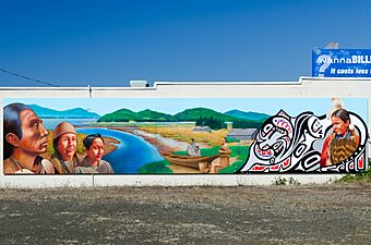
Mural in downtown Waldport, 2012
-
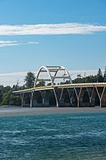
Alsea Bay Bridge at Waldport


See also
 In Spanish: Waldport para niños
