Alsea River facts for kids
Quick facts for kids Alsea River |
|
|---|---|

Upper Alsea Bay
|
|
|
Location of the mouth of the Alsea River in Oregon
|
|
| Country | United States |
| State | Oregon |
| County | Benton County, Lincoln County |
| Physical characteristics | |
| Main source | Lane County, Oregon 278 ft (85 m) 44°22′34″N 123°36′09″W / 44.37611°N 123.60250°W |
| River mouth | Alsea Bay, Pacific Ocean Waldport, Lincoln County, Oregon 0 ft (0 m) 44°25′21″N 124°04′51″W / 44.42250°N 124.08083°W |
| Length | 48.5 mi (78.1 km) |
| Basin features | |
| Basin size | 466 sq mi (1,210 km2) |
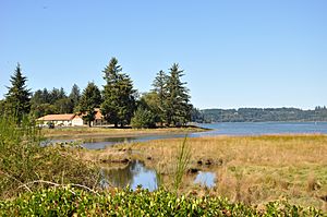
The Alsea River is a beautiful river in Oregon, USA. It flows for about 48.5 miles (78 kilometers) from the coastal mountains to the Pacific Ocean. The river starts where two smaller rivers, the North Fork Alsea River and the South Fork Alsea River, join together. It ends in a wide bay called Alsea Bay, near the town of Waldport.
The Alsea River flows mostly west through the mountains. It passes through parts of Benton and Lincoln counties. A large part of its journey is through the Siuslaw National Forest. The river's water comes from an area that also reaches into Lane County.
Contents
Fish and Wildlife
The Alsea River is a very important home for many types of fish. It supports different kinds of chinook and coho salmon. These fish are famous for swimming upstream to lay their eggs. You can also find steelhead and coastal cutthroat trout here. A special place called the Alsea River Fish Hatchery helps raise young fish. It is located along the North Fork Alsea River.
The River's Journey
The Alsea River begins in the Central Oregon Coast Range. This is near a small community called Alsea. From there, it flows generally west for about 48.5 miles (78 kilometers). Its journey ends at the Pacific Ocean in Waldport.
The river is formed when the South Fork Alsea River and the North Fork Alsea River meet. For most of its path, the river winds through the Siuslaw National Forest. Only the last 6 miles (10 kilometers) are outside this forest. Oregon Route 34 is a road that follows the river closely. It crosses the river once, about 8 miles (13 kilometers) from where the river meets the ocean.
Upper River Section
In its first part, the Alsea River picks up water from several smaller creeks. These include Cathcart Creek, Roberts Creek, and Mill Creek. The river then starts a long, U-shaped curve. This curve goes around the south side of Digger Mountain. This mountain is about 1,220 feet (372 meters) tall. Along this winding section, the river passes under Hayden Covered Bridge. It also receives water from other creeks like Schoolhouse Creek and Birch Creek. About 33.5 miles (54 kilometers) from the ocean, the river leaves Benton County. It then enters Lincoln County.
Middle River Section
As the river continues, it passes Little Digger Mountain. It also receives more water from creeks like Fall Creek and Wolf Creek. About 31 miles (50 kilometers) from the ocean, it passes Trenholm Saddle. This is a mountain gap. A bit further downstream, the river makes another U-shaped curve. This curve goes around the south side of Stoney Mountain, which is about 1,020 feet (311 meters) tall.
While flowing around Stoney Mountain, the Alsea River is joined by Five Rivers and Lake Creek. It also passes Blackberry Campground. More creeks, like Grass Creek and Schoolhouse Creek, add to its flow. Near the town of Tidewater, about 21 miles (34 kilometers) from the ocean, there is a special station. This station measures the river's water levels. Just a bit further, the river passes Slide Campground. It then enters a section with faster water called Hellion Rapids. After the rapids, more creeks join the river. The river then reaches Tidewater, about 12 miles (19 kilometers) from the ocean.
Lower River Section and Bay
Between Tidewater and Alsea Bay, the river continues to grow. It receives water from creeks like Mill Creek and Canal Creek. It passes under Oregon Route 34 again. This road then runs alongside the river on its south side. About 8 miles (13 kilometers) from the ocean, Arnold Creek joins the river. About 2 miles (3 kilometers) later, the river leaves the Siuslaw National Forest.
Soon after, the Alsea River is joined by Southworth Creek and Drift Creek. It also receives Eckman Creek. It passes W. B. Nelson State Recreation Site, which is a nice park. This is about 3 miles (5 kilometers) from the ocean. Here, the river flows into Alsea Bay. As part of the bay, it receives Lint Creek. It passes the town of Waldport. Finally, it flows under U.S. Route 101 and enters the vast Pacific Ocean at the mouth of the bay.
 | Calvin Brent |
 | Walter T. Bailey |
 | Martha Cassell Thompson |
 | Alberta Jeannette Cassell |


