Tidewater, Oregon facts for kids
Quick facts for kids
Tidewater, Oregon
|
|
|---|---|

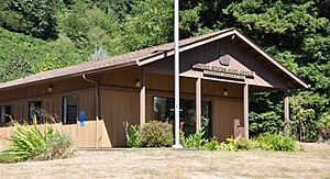
Post office in Tidewater
|
|
| Country | United States |
| State | Oregon |
| County | Lincoln |
| Elevation | 118 ft (36 m) |
| Time zone | UTC-8 (PST) |
| • Summer (DST) | UTC-7 (PDT) |
| ZIP codes |
97390
|
| Coordinates and elevation from United States Geological Survey | |
Tidewater is a small, unincorporated community in Lincoln County, Oregon, United States. This means it's a group of homes and businesses that isn't officially a city or town. It's located right on the Alsea River, east of the town of Waldport. You can find Tidewater along Oregon Route 34.
What's in a Name?
Tidewater got its name because of its special location. It's near the part of the Alsea River where the ocean's tide reaches. So, the water level here goes up and down with the ocean's tides. The Tidewater post office was first opened way back in 1878.
White Wolf Sanctuary
A very interesting place in Tidewater is the White Wolf Sanctuary. This sanctuary is a rescue center for Arctic wolves. It provides a safe home for these amazing animals.
Tidewater's Climate
Tidewater has a special kind of weather called a warm-summer Mediterranean climate. This means it has warm, dry summers, but they don't get too hot. The average high temperature in summer usually stays below 76 degrees Fahrenheit (24 degrees Celsius). Winters are generally mild and wet.
Understanding the Climate Data
The table below shows detailed weather information for Tidewater. It includes how hot or cold it gets and how much rain or snow falls each month.
- High F and Low F show the average high and low temperatures in Fahrenheit.
- Record high F and Record low F are the highest and lowest temperatures ever recorded for that month.
- Precipitation inch tells you how much rain or snow falls, measured in inches.
- Precipitation days shows how many days in a month usually have rain or snow.
- Snow inch tells you the average snowfall in inches.
| Climate data for Tidewater | |||||||||||||
|---|---|---|---|---|---|---|---|---|---|---|---|---|---|
| Month | Jan | Feb | Mar | Apr | May | Jun | Jul | Aug | Sep | Oct | Nov | Dec | Year |
| Record high °F (°C) | 68 (20) |
80 (27) |
81 (27) |
92 (33) |
95 (35) |
100 (38) |
106 (41) |
106 (41) |
100 (38) |
93 (34) |
80 (27) |
67 (19) |
106 (41) |
| Mean daily maximum °F (°C) | 49.5 (9.7) |
54.3 (12.4) |
57 (14) |
61 (16) |
66.1 (18.9) |
70 (21) |
74.6 (23.7) |
75.8 (24.3) |
74.5 (23.6) |
66.2 (19.0) |
55.5 (13.1) |
49.8 (9.9) |
62.9 (17.2) |
| Mean daily minimum °F (°C) | 36 (2) |
38 (3) |
38.5 (3.6) |
40.6 (4.8) |
44.4 (6.9) |
48.6 (9.2) |
51.8 (11.0) |
52.1 (11.2) |
49.7 (9.8) |
45.7 (7.6) |
40.6 (4.8) |
37.4 (3.0) |
43.6 (6.4) |
| Record low °F (°C) | 8 (−13) |
10 (−12) |
23 (−5) |
26 (−3) |
30 (−1) |
35 (2) |
38 (3) |
40 (4) |
29 (−2) |
25 (−4) |
17 (−8) |
5 (−15) |
5 (−15) |
| Average precipitation inches (mm) | 14.45 (367) |
12.07 (307) |
11 (280) |
6.58 (167) |
4.12 (105) |
2.46 (62) |
0.81 (21) |
1.12 (28) |
2.88 (73) |
6.84 (174) |
13.48 (342) |
15.32 (389) |
91.15 (2,315) |
| Average snowfall inches (cm) | 1.3 (3.3) |
0.7 (1.8) |
0.1 (0.25) |
0 (0) |
0 (0) |
0 (0) |
0 (0) |
0 (0) |
0 (0) |
0 (0) |
0.1 (0.25) |
0.4 (1.0) |
2.5 (6.4) |
| Average precipitation days | 20 | 18 | 19 | 16 | 13 | 9 | 4 | 4 | 8 | 13 | 20 | 21 | 165 |
 | Jackie Robinson |
 | Jack Johnson |
 | Althea Gibson |
 | Arthur Ashe |
 | Muhammad Ali |


