
Pacific City, Oregon facts for kids
Quick facts for kids
Pacific City, Oregon
|
|
|---|---|

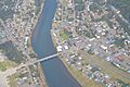
Aerial view of Pacific City
|
|

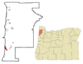
Location of Pacific City, Oregon
|
|
| Country | United States |
| State | Oregon |
| County | Tillamook |
| Area | |
| • Total | 3.83 sq mi (9.91 km2) |
| • Land | 3.72 sq mi (9.63 km2) |
| • Water | 0.11 sq mi (0.28 km2) |
| Elevation | 7 ft (2 m) |
| Population
(2020)
|
|
| • Total | 1,109 |
| • Density | 298.28/sq mi (115.15/km2) |
| Time zone | UTC-8 (Pacific (PST)) |
| • Summer (DST) | UTC-7 (PDT) |
| ZIP Code |
97135
|
| Area code(s) | 503 |
| FIPS code | 41-56150 |
| GNIS feature ID | 2409013 |


Pacific City is a small town located in Tillamook County, Oregon, in the United States. It's known as a census-designated place (CDP), which means it's a community identified by the U.S. Census Bureau. In 2020, about 1,109 people lived there. Pacific City is also home to the beautiful Cape Kiwanda State Natural Area.
Contents
History of Pacific City
Early Days and a Big Fire
In 1845, a cook named Mr. Johnson left an English ship on the Columbia River. He settled in Champoeg and tried to clear land by burning brush. This fire, known as the Champoeg Fire, grew out of control.
The wind changed direction and blew the fire into the dry Coast Range. It burned for weeks in the Yamhill basin. This huge fire destroyed about 1.5 million acres (6,070 square kilometers) of old forests. It was one of the biggest forest fires in U.S. history.
Impact on Native Americans
No settlers lived west of the Coast Range at that time. However, small groups of Native Americans lived there. Many had already been affected by illnesses between 1830 and 1841. The fire forced them to leave their lands.
The Nestuggas were one such tribe. They lived near Pacific City, close to the town of Woods. They had seen smoke for weeks. One morning, the bright flames reached their hills and rushed towards them. The Nestuggas quickly escaped by canoe down the Big Nestucca River to the ocean. They found safety on a sandy strip of land between Nestucca Bay and the ocean.
After several weeks, heavy rain finally stopped the fires. But the land was completely destroyed. The forests were gone, and many animals had died in the blaze.
Settlers Arrive and Changes Begin
Nestucca Bay was a great place for fishing, which helped the Nestuggas survive. But in 1854, new settlers started arriving in the Tillamook Valley. By 1876, Chief Nestugga Bill and the remaining 200 people of his tribe were moved to a reservation. This reservation was located on the Salmon and Siletz River.
Many early pioneers came by steamship. Others traveled across the mountains. The town of Woods became a hub for new arrivals. It provided supplies and trade for the settlers. In 1886, the Linewebber and Brown cannery opened. It used the many fish from Nestucca Bay. The cannery shipped 12,000 cans of salmon each year. This helped the local economy until 1926. Logging and dairy farming were also important jobs. The area also became a popular vacation spot for pioneers from the Midwest who had never seen the ocean.

Growth and New Name
In 1893, Thomas Malaney planned a new town called Ocean Park. It was built across the river from Woods. A flood in 1894 washed away the first lots. So, Malaney moved the town south to higher ground. Around 1895, the Sea View hotel was built for vacationers. It was later renamed Edmundes Hotel. Other buildings and campgrounds were also created for visitors. Ferry Street was even paved with wooden planks for cars!
The town changed its name to Pacific City in 1909. This was to avoid confusion with another town called Ocean Park in Washington. By 1926, too much fishing had reduced the number of salmon in the bay. So, commercial salmon fishing stopped. Fishermen then started using special boats called dories, launched directly from the beach. Over time, fewer people used dories for commercial fishing. Today, only a few people keep this tradition alive for fun.
In the 1920s, tourism became the main way people made money in Pacific City. This lasted until the Great Depression in the 1930s. An airport was built to attract pilots. More roads and bridges also opened, making it easier to visit.
Geography and Climate
Where is Pacific City?
Pacific City is located right on the Pacific Ocean. It's next to Bob Straub State Park. The town also stretches across the Nestucca River. About half of the town is behind Nestucca Bay. It is part of the beautiful Oregon Coast.
The area is about 13 feet (4 meters) above sea level. According to the U.S. Census Bureau, Pacific City covers about 3.8 square miles (9.9 square kilometers). Most of this area is land, with a small part being water.
Weather in Pacific City
Pacific City has a mild climate. Summers are generally warm, and winters are cool and wet. The average high temperature in July is about 70 degrees Fahrenheit (21 degrees Celsius). In January, the average high is around 50 degrees Fahrenheit (10 degrees Celsius).
The town gets a lot of rain, especially in winter. December and November are the wettest months. Snowfall is very rare, usually less than an inch per year.
Population and People
Who Lives in Pacific City?
In 2020, Pacific City had a population of 1,109 people. Back in 2000, there were 1,027 people living there. Most of the people living in Pacific City are White. There are also smaller groups of Native American and Asian residents. About 3% of the population identifies as Hispanic or Latino.
In 2000, there were 485 households in Pacific City. About 13.4% of these households had children under 18 living with them. Many households (54.8%) were married couples. About 30% of all households were made up of people living alone. Many older adults (65 years or older) also live by themselves.
The average age of people in Pacific City in 2000 was 53 years old. This means it's a community with many adults and older residents.
Infrastructure and Connections
Underwater Cables
Pacific City is an important spot for internet connections! It's where several undersea telecommunications cables come ashore. These huge cables lie on the ocean floor and carry internet data across continents.
- The Hawaiki Cable connects Pacific City to places like Los Angeles, Hawaii, and even Australia and New Zealand.
- The New Cross Pacific (NCP) Cable System connects Pacific City to East Asia. This includes countries like South Korea, Japan, and China.
These cables help connect the United States with many other parts of the world.
Getting Around Pacific City
Pacific City is located about 2.8 miles (4.5 kilometers) from U.S. Route 101. This is a major highway along the Oregon coast.
The town also has its own small airport, the Pacific City State Airport. It's about 1,875 feet (572 meters) long. The Oregon Department of Aviation owns and takes care of it.
If you don't have a car, the Tillamook County Transportation District offers bus service. There are two bus stops in Pacific City. You can take a bus to Tillamook, a larger town nearby.
Images for kids
-
Aerial view of Pacific City
-
Location of Pacific City, Oregon
See also
 In Spanish: Pacific City para niños
