Bunker Hill, Oregon facts for kids
Quick facts for kids
Bunker Hill, Oregon
|
|
|---|---|

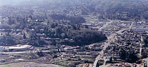
Aerial view of Bunker Hill from the east in 2005
|
|

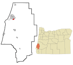
Location of Bunker Hill, Oregon
|
|
| Country | United States |
| State | Oregon |
| County | Coos |
| Area | |
| • Total | 1.59 sq mi (4.12 km2) |
| • Land | 1.46 sq mi (3.78 km2) |
| • Water | 0.13 sq mi (0.34 km2) |
| Elevation | 128 ft (39 m) |
| Population
(2020)
|
|
| • Total | 1,465 |
| • Density | 1,003.42/sq mi (387.51/km2) |
| Time zone | UTC−08:00 (Pacific (PST)) |
| • Summer (DST) | UTC−07:00 (PDT) |
| ZIP code |
97420
|
| Area code(s) | 458 and 541 |
| FIPS code | 41-09600 |
| GNIS feature ID | 2407922 |
Bunker Hill is a community located in Coos County, Oregon, in the United States. It is known as a census-designated place (CDP). This means it is an area that looks like a town or village. However, it does not have its own local government. Instead, it is part of the larger county.
In 2020, about 1,465 people lived in Bunker Hill. This number helps us understand the size of the community.
Contents
Geography and Climate of Bunker Hill
This section tells us about the land and weather in Bunker Hill.
Where is Bunker Hill Located?
Bunker Hill is in Oregon, a state on the west coast of the United States. It is part of Coos County. The community covers a total area of about 4.12 square kilometers (1.59 square miles). Most of this area is land. A small part, about 0.34 square kilometers (0.13 square miles), is water.
What is the Weather Like?
The weather in Bunker Hill is generally mild. It has warm summers and cool, wet winters.
Here are some details about the climate:
- Warmest Month: August is usually the warmest month. The average high temperature is around 20 degrees Celsius (68 degrees Fahrenheit).
- Coolest Month: December is typically the coolest month. The average low temperature is about 3 degrees Celsius (37 degrees Fahrenheit).
- Rainfall: Bunker Hill gets a lot of rain. The wettest months are usually November and December. They can get over 25 centimeters (10 inches) of rain each.
- Snow: Snow is very rare in Bunker Hill. If it snows, it's usually just a tiny bit in February or December.
| Climate data for Bunker Hill, Oregon | |||||||||||||
|---|---|---|---|---|---|---|---|---|---|---|---|---|---|
| Month | Jan | Feb | Mar | Apr | May | Jun | Jul | Aug | Sep | Oct | Nov | Dec | Year |
| Mean daily maximum °F (°C) | 53 (12) |
54 (12) |
56 (13) |
58 (14) |
61 (16) |
64 (18) |
67 (19) |
68 (20) |
68 (20) |
64 (18) |
56 (13) |
52 (11) |
60 (16) |
| Mean daily minimum °F (°C) | 38 (3) |
38 (3) |
39 (4) |
41 (5) |
45 (7) |
49 (9) |
52 (11) |
51 (11) |
48 (9) |
44 (7) |
40 (4) |
37 (3) |
44 (7) |
| Average precipitation inches (mm) | 9.8 (250) |
7.7 (200) |
7.7 (200) |
5.3 (130) |
3.3 (84) |
1.9 (48) |
0.5 (13) |
0.6 (15) |
1.6 (41) |
4.5 (110) |
10.1 (260) |
11.4 (290) |
64.4 (1,640) |
| Average snowfall inches (cm) | 0 (0) |
0.2 (0.51) |
0 (0) |
0 (0) |
0 (0) |
0 (0) |
0 (0) |
0 (0) |
0 (0) |
0 (0) |
0 (0) |
0.1 (0.25) |
0.3 (0.76) |
People Living in Bunker Hill (Demographics)
Demographics is the study of a population. It looks at how many people live in a place. It also looks at things like their age or how many families there are.
Population Count
The United States Census Bureau counts the population every ten years. This helps us know how many people live in Bunker Hill.
- In 2010, the population was 1,444 people.
- By 2020, the population had grown slightly to 1,465 people.
| Historical population | |||
|---|---|---|---|
| Census | Pop. | %± | |
| 2020 | 1,465 | — | |
| U.S. Decennial Census | |||
See also
 In Spanish: Bunker Hill (Oregón) para niños
 | Valerie Thomas |
 | Frederick McKinley Jones |
 | George Edward Alcorn Jr. |
 | Thomas Mensah |

