
National Register of Historic Places listings in Coos County, Oregon facts for kids
Did you know that places can be famous too, just like people? In Coos County, Oregon, there are many special buildings, bridges, and even old Native American sites that are listed on something called the National Register of Historic Places. This is like a special list kept by the United States government to protect important places. These places tell us amazing stories about the past, showing us how people lived, worked, and built things long ago. By keeping them safe, we can learn about history and understand more about our community.
Contents
Cool Historic Places in Coos County
Let's explore some of the interesting places in Coos County that are on this special list!
Lighthouses and Coastal Wonders
The coast of Coos County is home to some beautiful and important lighthouses that helped ships navigate safely.
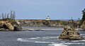
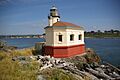
Cape Arago Lighthouse

The Cape Arago Lighthouse is a super cool lighthouse located near Charleston, Oregon. It was first built in 1866 to guide ships along the coast. Imagine how important it was for sailors to see its light in the dark or during foggy weather! The lighthouse was rebuilt a few times, with the current tower finished in 1934. It's a true symbol of the Oregon coast.
Coquille River Light

Near Bandon, Oregon, you'll find the Coquille River Light. This lighthouse was built in 1896 and helped ships find their way into the Coquille River. It's located in Bullard's Beach State Park, which is a great place to visit. The light was turned off in 1939, but it was later restored and now shines again as a historic landmark.
Important Buildings and Community Hubs
Many buildings in Coos County have played a big part in the lives of the people who lived there.
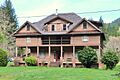
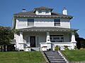
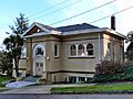
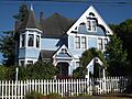
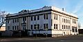
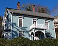
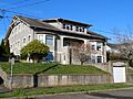
Edwin and Ethel Abernethy House

The Edwin and Ethel Abernethy House is a historic home located near Myrtle Point, Oregon. It was added to the list in 1988. This house is a great example of the kind of homes people built in the area many years ago.
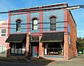
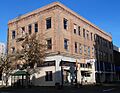
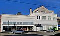
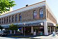
A. H. Black and Company Building

In Myrtle Point, Oregon, the A. H. Black and Company Building stands as a reminder of the town's past. Built in 1909, this building was once a general store. It was a place where people could buy all sorts of things, from food to tools, and it was an important part of the community's daily life.
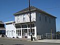
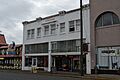
Breuer Building

The Breuer Building in Bandon, Oregon, is another interesting historic spot. It was added to the National Register in 1992. Buildings like this help us imagine what the streets of Bandon looked like a long time ago.
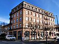
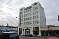
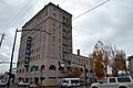
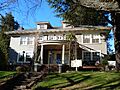
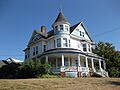
Chandler Hotel and Annex

The Chandler Hotel and Annex in Coos Bay, Oregon, was a busy place when it was built in 1908. Hotels like this were important for travelers and new settlers coming to the area. It was added to the list in 1984.
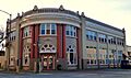
Coos Bay Carnegie Library

Libraries are super important for learning, and the Coos Bay Carnegie Library is a historic example. Built in 1914 with money from famous businessman Andrew Carnegie, it has served the community of Coos Bay, Oregon, for over a hundred years. It was listed in 1986.
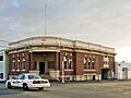
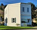
Coquille City Hall

The Coquille City Hall in Coquille, Oregon, is where many important decisions for the city have been made over the years. This building, added to the list in 1992, shows us the history of local government in the area.
Egyptian Theatre

The Egyptian Theatre in Coos Bay, Oregon, is a really cool building with a unique design, made to look like ancient Egyptian temples. Opened in 1925, it was a popular place for people to watch movies and shows. It was added to the list in 2010 and is still a special place for entertainment.
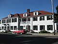
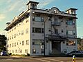
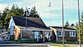
Hotel North Bend
.jpg)
The Hotel North Bend in North Bend, Oregon, was built in 1922. It was a fancy place for people to stay and gather. This hotel, listed in 2005, tells us about the growth and development of North Bend.
Marshfield Sun Printing Plant

The Marshfield Sun Printing Plant in Coos Bay, Oregon, is a historic building where newspapers were printed. Imagine the news of the day being put together right here! It was listed in 1973 and shows us how important local newspapers were in the past.
Tribal Hall of the Confederated Tribes of Coos, Lower Umpqua and Siuslaw Indians

The Tribal Hall of the Confederated Tribes of Coos, Lower Umpqua and Siuslaw Indians in Coos Bay, Oregon, is a very important place for the local Native American tribes. It was added to the National Register in 1989. This building represents the history and ongoing community of these tribes.
Bridges and Other Structures
Not just buildings, but also bridges and other structures can be historically important.
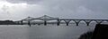
Coos Bay Bridge No. 01823

The Coos Bay Bridge No. 01823 is a big bridge on US Highway 101 in North Bend, Oregon. It was built in 1936 and is a great example of bridge engineering from that time. It was added to the list in 2005 and is still a very important part of transportation in the area.
Sandy Creek Bridge
.jpg)
The Sandy Creek Bridge near Remote, Oregon, is another historic bridge. Built in 1924, it's a good example of early 20th-century bridge construction. It was listed in 1979.
Images for kids
-
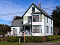
The Edwin and Ethel Abernethy House near Myrtle Point.
-
The A. H. Black and Company Building in Myrtle Point.
-
The Breuer Building in Bandon.
-
The Cape Arago Lighthouse, a historic beacon.
-

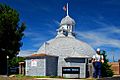
An overlook near Cape Arago Site (35CS10).
-
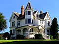
The Leo J. Cary House in Coquille.
-
The historic Chandler Hotel in Coos Bay.
-
The J. S. Coke Building in Coos Bay.
-
The Coos Bay Bridge, a vital link.
-
The beautiful Coos Bay Carnegie Library.
-
The Coos Bay National Bank Building.
-
The Coquille City Hall, a center of local government.
-
The Coquille River Life Boat Station in Bandon.
-
The Coquille River Light stands proudly at Bullard's Beach State Park.
-
The unique Egyptian Theatre in Coos Bay.
-
The First National Bank of Bandon.
-
The Judge Lintner Harlocker House in Coquille.
-
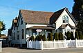
The grand Hotel North Bend.
-
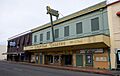
The Hub Department Store Building in Coos Bay.
-
The Koski Building in Coos Bay.
-
The Marshfield City Hall in Coos Bay.
-
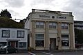
The Marshfield Elks Temple in Coos Bay.
-
The Marshfield Hotel in Coos Bay.
-
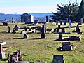
The Marshfield I.O.O.F. Cemetery.
-
The Marshfield Sun Printing Plant, where news was made.
-
The Myrtle Arms Apartment Building in Coos Bay.
-
The Nasburg–Lockhart House in Coos Bay.
-
The Hjalte Nerdrum House in Coos Bay.
-
The Nerdrum–Conrad House in Coos Bay.
-
The Captain Bror W. Olsson House in Coos Bay.
-
The John E. and Christina Paulson House in Coquille.
-
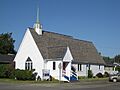
The Reorganized Church of Latter Day Saints in Myrtle Point.
-
St. James Episcopal Church in Coquille.
-
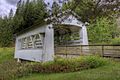
The historic Sandy Creek Bridge.
-
The A. J. Sherwood House in Coquille.
-
The Maj. Morton Tower House in Coos Bay.
-
The Tower–Flanagan House in Coos Bay.
-
The Tribal Hall, a significant place for local Native American tribes.


.jpg)


.jpg)


.jpg)


_(cooDA0164).jpg)

.jpg)


