
Cape Arago Lighthouse facts for kids
 |
|
| Cape Arago Lighthouse | |

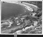
Cape Arago Lighthouse
Location in Oregon
|
|
| Location | Gregory Point, Charleston, Oregon |
|---|---|
| Coordinates | 43°20′28″N 124°22′32″W / 43.34123°N 124.37543°W |
| Year first lit | 1934 |
| Automated | 1966 |
| Deactivated | 2006 |
| Foundation | Concrete |
| Construction | Reinforced concrete |
| Tower shape | Octagonal attached to fog signal building |
| Height | 44 feet (13 m) |
| Original lens | Fourth order Fresnel |
| Range | 14 nautical miles; 26 kilometres (16 mi) |
| Characteristic | Group Flash White, 20 seconds 3 Flashes |
The Cape Arago Lighthouse is a famous lighthouse located in Charleston, Oregon. It was once known as the Cape Gregory Lighthouse. You can find it about 2.6 miles (4.2 km) north of Cape Arago.
Contents
History of the Lighthouse
Why a Lighthouse Was Needed

In the mid-1800s, Coos Bay became a very important shipping spot. Many ships used this area on the west coast of the United States. Because so many ships were passing through, people realized a lighthouse was needed.
In 1864, money was set aside to build a light for the harbor. Two years later, in 1866, the first light was turned on.
The First Lighthouse (1866)
The first lighthouse was a 25-foot (7.6 m) tall octagonal tower. It had an open, skeleton-like base. This tower held a special Fresnel lens, which made the light very bright.
The lighthouse stood on the west end of an island. A long wooden walkway, about 1,300 feet (400 m) long, connected it to the lighthouse keeper's home.
However, the lighthouse was very exposed to the strong winds and waves of the Pacific Ocean. Because of this, it often needed repairs. Over the next 35 years, many parts of the station had to be fixed or replaced. They also added a fog signal and a new boathouse.
The Second Lighthouse (1909)

Sailors wanted an even better light. Also, the land around the first lighthouse was wearing away due to erosion. So, in 1909, a second lighthouse was built.
This new wooden tower was much taller, standing 100 feet (30 m) high. It was placed higher up on the island, which helped it shine brighter. A man named Carl Leick designed it. Its style was similar to the Mukilteo Light in Washington.
The Third Lighthouse (1934)
Unfortunately, erosion continued to be a problem. It even threatened the second lighthouse. So, in 1934, the third and current lighthouse was lit.
This new tower was made from strong concrete. This helped it stand up better against the rough weather. It used the same fourth-order lens from the second lighthouse. Its design was similar to the Point Robinson Light in Washington.
At this time, the very first lighthouse, which was still standing, was finally taken down. The second lighthouse was also removed, but its building was saved and turned into an office.
Automation and Decommissioning
In 1966, the lighthouse became automated. This means machines took over the job of the lighthouse keepers. In 1993, the old Fresnel lens was replaced with a newer, more modern one.
The lighthouse continued to guide ships into Coos Bay for another 12 years. But on January 1, 2006, it was officially turned off.
Today, only the third lighthouse tower remains. All the other buildings have been taken down. The area around the lighthouse is fenced off, so you cannot visit it. In the winter of 2012–2013, the original wooden bridge that led to the light was washed away by the sea.
You can still see the lighthouse from a distance. It is visible between Sunset Bay State Park and Shore Acres State Park. You can also spot it from Bastendorff Beach County Park.
In 1993, the Cape Arago Lighthouse was added to the National Register of Historic Places. This means it is recognized as an important historical site.
