Myrtle Point, Oregon facts for kids
Quick facts for kids
Myrtle Point, Oregon
|
|
|---|---|

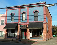
Historic Black and Co. Building
|
|

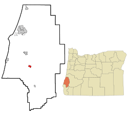
Location in Oregon
|
|
| Country | United States |
| State | Oregon |
| County | Coos |
| Incorporated | 1887 |
| Area | |
| • Total | 1.62 sq mi (4.19 km2) |
| • Land | 1.61 sq mi (4.16 km2) |
| • Water | 0.01 sq mi (0.03 km2) |
| Elevation | 128 ft (39 m) |
| Population
(2020)
|
|
| • Total | 2,475 |
| • Density | 1,540.14/sq mi (594.62/km2) |
| Time zone | UTC-8 (Pacific) |
| • Summer (DST) | UTC-7 (Pacific) |
| ZIP code |
97458
|
| Area code(s) | 458 and 541 |
| FIPS code | 41-51050 |
| GNIS feature ID | 2411205 |
| Website | http://www.ci.myrtlepoint.or.us/ |
Myrtle Point is a city in Coos County, Oregon, United States. It was officially started in 1887. In 2020, about 2,475 people lived there.
Myrtle Point is located in the Coquille River Valley. It's part of a larger area that includes Coos Bay, North Bend, and Charleston. This whole area is in Coos County.
Contents
About Myrtle Point
Where is Myrtle Point Located?
Myrtle Point is in southwestern Oregon, about 15 miles (24 km) from the Pacific Ocean. The city covers an area of about 1.62 square miles (4.19 square kilometers). Most of this area is land, with a small part being water.
Oregon Route 42 is a main road that goes through Myrtle Point. It connects the city to places like Roseburg and Coos Bay. The city is also near where different parts of the Coquille River meet.
What's the Weather Like?
Myrtle Point has a mild and wet climate because it's close to the Pacific Ocean. Summers are usually warmer and sunnier than in towns right on the coast, but it rarely gets extremely hot or cold. This type of weather is called a warm-summer Mediterranean climate.
- The warmest month is August, with average high temperatures around 78°F (25.5°C).
- The coldest month is January, with average low temperatures around 34°F (1.1°C).
- The highest temperature ever recorded was 107°F (41.6°C) in August 2020.
- The lowest temperature ever recorded was 5°F (-15°C) in February 1989.
Who Lives in Myrtle Point?
| Historical population | |||
|---|---|---|---|
| Census | Pop. | %± | |
| 1880 | 52 | — | |
| 1890 | 354 | 580.8% | |
| 1900 | 530 | 49.7% | |
| 1910 | 836 | 57.7% | |
| 1920 | 934 | 11.7% | |
| 1930 | 1,362 | 45.8% | |
| 1940 | 1,296 | −4.8% | |
| 1950 | 2,033 | 56.9% | |
| 1960 | 2,886 | 42.0% | |
| 1970 | 2,511 | −13.0% | |
| 1980 | 2,859 | 13.9% | |
| 1990 | 2,712 | −5.1% | |
| 2000 | 2,451 | −9.6% | |
| 2010 | 2,514 | 2.6% | |
| 2020 | 2,475 | −1.6% | |
| source: | |||
In 2010, there were 2,514 people living in Myrtle Point. This means there were about 1,561 people per square mile (602 people per square kilometer).
There were 1,027 households in the city. About 30.8% of these households had children under 18 living with them. The average household had about 2.41 people.
The average age of people in Myrtle Point was 44.9 years old.
- About 23% of residents were under 18.
- About 21.8% of residents were 65 or older.
- The city had slightly more females (51.8%) than males (48.2%).
Fun Things to Do
Myrtle Point is home to the Coos County Fair, which happens every year. It's a fun event for everyone!
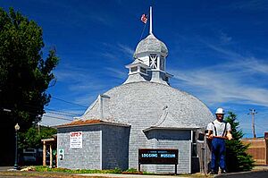
You can also visit the Coos County Logging Museum in Myrtle Point. This museum teaches you about the history of logging in the area.
How the City Works
Myrtle Point has important services that help the city run smoothly. These include:
- Electricity: Provided by Pacific Power.
- Internet and Phone: Services like high-speed internet and phone are available from companies like Ziply Fiber, DFN, and Charter Communications.
- Water and Sewer: The City of Myrtle Point manages the water and sewer systems.
Famous People from Myrtle Point
Some notable people have connections to Myrtle Point:
- Robert C. Belloni: A Chief Judge for the United States District Court for the District of Oregon.
- Dennis Waterman: A professional poker player and writer.
See also
 In Spanish: Myrtle Point para niños
 | Bessie Coleman |
 | Spann Watson |
 | Jill E. Brown |
 | Sherman W. White |


