Powers, Oregon facts for kids
Quick facts for kids
Powers, Oregon
|
|
|---|---|

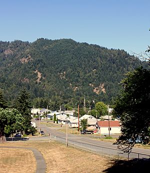
Powers, Oregon skyline
|
|

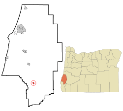
Location in Oregon
|
|
| Country | United States |
| State | Oregon |
| County | Coos |
| Incorporated | 1945 |
| Area | |
| • Total | 0.63 sq mi (1.64 km2) |
| • Land | 0.58 sq mi (1.51 km2) |
| • Water | 0.05 sq mi (0.13 km2) |
| Elevation | 266 ft (81 m) |
| Population
(2020)
|
|
| • Total | 710 |
| • Density | 1,215.75/sq mi (469.69/km2) |
| Time zone | UTC-8 (Pacific) |
| • Summer (DST) | UTC-7 (Pacific) |
| ZIP code |
97466
|
| Area code(s) | 541 |
| FIPS code | 41-59600 |
| GNIS feature ID | 2411482 |
Powers is a small city in Coos County, Oregon, United States. In 2010, about 689 people lived there.
Contents
Geography and Location
Powers is located in southwestern Oregon. It's about 21 miles (34 km) south of Myrtle Point. The city sits along the South Fork Coquille River.
You can reach Powers by taking Oregon Route 542, also known as Powers Highway. There are also forest roads that connect Powers to the Rogue River, which is about 35 miles (56 km) further south. A bike trail called the Glendale–Powers Bike Trail also goes through the city.
The city of Powers covers a total area of about 0.64 square miles (1.66 square kilometers). Most of this area is land, with a small part being water.
Climate and Weather
Powers has cool, very wet winters. The summers are warm and mostly dry. The nearby Pacific Ocean helps keep the temperatures mild, especially in summer. At night, summer temperatures often drop to around 40 to 50 degrees Fahrenheit (4 to 10 degrees Celsius).
Temperature Details
- Coldest Month: January, with average high temperatures around 53°F (12°C) and lows around 35°F (2°C).
- Warmest Month: August, with average highs around 79°F (26°C) and lows around 51°F (11°C).
- Record High: The hottest temperature ever recorded was 105°F (41°C) on August 4, 1932.
- Record Low: The coldest temperature was 5°F (-15°C) on December 31, 1990.
- Hot Days: On average, Powers has about 6.5 days each year where the temperature reaches 90°F (32°C) or higher.
- Freezing Nights: There are about 45 days each year where the temperature drops to 32°F (0°C) or lower.
Rainfall and Snow
Powers gets a lot of rain, averaging about 60.74 inches (1,543 mm) per year. It rains on about 138 days each year.
- Wettest Year: 1996, with 95.35 inches (2,422 mm) of rain.
- Driest Year: 1976, with 31.69 inches (805 mm) of rain.
- Most Rain in a Day: 6.25 inches (159 mm) fell on November 19, 1996.
Even though it rains a lot, Powers doesn't get much snow. The city averages only about 2.5 inches (6.4 cm) of snow each year. The mountains around Powers get more snow.
- Snowiest Year: 1950, when 18.4 inches (47 cm) of snow fell.
Powers has a type of climate called a warm-summer Mediterranean climate. This means it has warm, dry summers and mild, wet winters.
| Climate data for Powers, Oregon | |||||||||||||
|---|---|---|---|---|---|---|---|---|---|---|---|---|---|
| Month | Jan | Feb | Mar | Apr | May | Jun | Jul | Aug | Sep | Oct | Nov | Dec | Year |
| Record high °F (°C) | 74 (23) |
83 (28) |
88 (31) |
93 (34) |
99 (37) |
102 (39) |
101 (38) |
105 (41) |
103 (39) |
103 (39) |
85 (29) |
73 (23) |
105 (41) |
| Mean daily maximum °F (°C) | 53.9 (12.2) |
56.6 (13.7) |
59.4 (15.2) |
62.7 (17.1) |
67.9 (19.9) |
72.7 (22.6) |
78.6 (25.9) |
80.4 (26.9) |
79.4 (26.3) |
70.0 (21.1) |
57.8 (14.3) |
51.6 (10.9) |
65.9 (18.8) |
| Mean daily minimum °F (°C) | 37.4 (3.0) |
37.6 (3.1) |
39.1 (3.9) |
41.2 (5.1) |
46.0 (7.8) |
49.9 (9.9) |
53.0 (11.7) |
52.4 (11.3) |
48.6 (9.2) |
43.4 (6.3) |
40.5 (4.7) |
36.6 (2.6) |
43.8 (6.6) |
| Record low °F (°C) | 9 (−13) |
7 (−14) |
23 (−5) |
26 (−3) |
28 (−2) |
31 (−1) |
33 (1) |
34 (1) |
29 (−2) |
20 (−7) |
17 (−8) |
3 (−16) |
3 (−16) |
| Average precipitation inches (mm) | 9.37 (238) |
7.49 (190) |
7.88 (200) |
5.42 (138) |
2.90 (74) |
1.31 (33) |
0.29 (7.4) |
0.32 (8.1) |
1.13 (29) |
3.76 (96) |
7.93 (201) |
10.82 (275) |
60.33 (1,532) |
| Average snowfall inches (cm) | 0.3 (0.76) |
0.2 (0.51) |
0 (0) |
0 (0) |
0 (0) |
0 (0) |
0 (0) |
0 (0) |
0 (0) |
0 (0) |
0 (0) |
0.1 (0.25) |
0.6 (1.5) |
| Average precipitation days | 18 | 16 | 18 | 14 | 11 | 7 | 2 | 3 | 5 | 11 | 16 | 18 | 139 |
| Source: — NOAA | |||||||||||||
History of Powers
The city of Powers was named in 1914 after Albert H. Powers. He was an important person in the Smith-Powers Logging Company. The Powers post office, which handles mail, was set up in 1915.
Things to See and Do
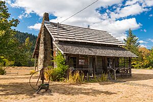
- Wagner House: This old house is thought to be the oldest pioneer home in the area. It's located next to a railroad museum.
- Forest Service Office: The United States Forest Service (USFS) has an office in Powers.
- Powers County Park: This park is a great place for camping and other outdoor activities.
- Siskiyou National Forest: About 5 miles (8 km) south of Powers, you'll find the Siskiyou National Forest. It has many campgrounds and beautiful nature trails.
- White Cedar Days: Powers celebrates July 4th with a special festival called White Cedar Days.
Education in Powers
Students in Powers attend two public schools:
- An elementary school for grades Kindergarten through 6th grade.
- Powers High School for grades 7th through 12th grade.
Population and People
Powers is a small community. Here's how its population has changed over the years:
| Historical population | |||
|---|---|---|---|
| Census | Pop. | %± | |
| 1920 | 160 | — | |
| 1950 | 895 | — | |
| 1960 | 1,366 | 52.6% | |
| 1970 | 842 | −38.4% | |
| 1980 | 819 | −2.7% | |
| 1990 | 682 | −16.7% | |
| 2000 | 734 | 7.6% | |
| 2010 | 689 | −6.1% | |
| 2020 | 710 | 3.0% | |
| source: | |||
In 2010, there were 689 people living in Powers. These people lived in 314 households. About 45% of the households were families. The average age of people in the city was about 51.8 years old.
Transportation
- Powers Airport is located near the city.
See also
 In Spanish: Powers (Oregón) para niños
 | Dorothy Vaughan |
 | Charles Henry Turner |
 | Hildrus Poindexter |
 | Henry Cecil McBay |


