South Fork Coquille River facts for kids
Quick facts for kids South Fork Coquille River |
|
|---|---|

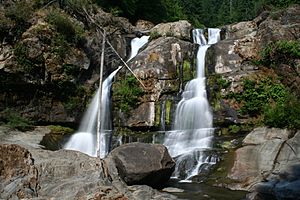
The lower tier of Coquille River Falls at low water
|
|
|
Location of the mouth of the South Fork Coquille River in Oregon
|
|
| Country | United States |
| State | Oregon |
| Region | Coos County |
| Cities | Powers, Broadbent, Myrtle Point |
| Physical characteristics | |
| Main source | Southern Oregon Coast Range Unnamed ridge, north of Mount Bolivar 3,501 ft (1,067 m) 42°50′24″N 123°52′30″W / 42.84000°N 123.87500°W |
| River mouth | Coquille River Myrtle Point 13 ft (4.0 m) 43°04′49″N 124°08′29″W / 43.08028°N 124.14139°W |
| Length | 62.8 mi (101.1 km) |
| Basin features | |
| Basin size | 288 sq mi (750 km2) |
| Tributaries |
|
The South Fork Coquille River is a long river in coastal Oregon, United States. It's the longest stream that flows into the main Coquille River. This river starts high up in the Southern Oregon Coast Range.
The South Fork flows mostly northwest. It eventually joins with the North Fork Coquille River at a town called Myrtle Point. When these two rivers meet, they form the larger Coquille River. The South Fork is about 63 miles (101 kilometers) long. Its watershed, which is the land area that drains water into the river, covers about 288 square miles (746 square kilometers) in Coos County.
Contents
Journey of the South Fork Coquille River
The South Fork Coquille River begins as a small stream. It starts in a place called Eden Valley. This spot is about 2.5 miles (4 kilometers) northwest of Mount Bolivar in the Siskiyou National Forest. As it flows, many smaller streams, called tributaries, join it. Some of these include Wooden Rock, Clear, and Panther Creeks.
River's Path Through Canyons and Valleys
The river gets bigger as it moves southwest into a deep canyon. When it meets Rock Creek, the river suddenly turns north. A few miles later, Johnson Creek flows into it from the left side. Now, the South Fork is a fairly large stream. It winds through more canyons until Coal Creek joins it. After this, the river enters a flat, wide area called an alluvial valley near the small town of Powers.
Below Powers, the South Fork continues north through another canyon. It then opens into a wide valley. Oregon Route 542 follows the river here. You can also find Coquille Myrtle Grove State Natural Site and Albert H. Powers Memorial State Park along its banks.
Meeting Other Rivers and Waterfalls
About a mile downstream from the parks, Dement Creek joins the river. The land around the river changes from hills to open farmland. The river starts to curve and bend more as it passes Broadbent. Then, the Middle Fork Coquille River flows into it. This is the biggest tributary of the South Fork. At this point, the river becomes affected by the ocean's tides, which is called the head of tide.
A few miles further, the river passes through Myrtle Point. Here, it finally meets the North Fork Coquille River. Together, they form the main Coquille River. This meeting point is about 36 miles (58 kilometers) from the Pacific Ocean.
The South Fork Coquille River also has two impressive waterfalls. They are located in a steep canyon. These are the 35-foot (11-meter) Upper Coquille River Falls. The other is the much taller 110-foot (34-meter) Coquille River Falls.
Understanding the River's Watershed
The watershed of the South Fork Coquille River is the entire area of land where all the rain and snowmelt drain into this river and its tributaries. This area does not have many people living in it. Most of the residents are found in the towns of Powers and Myrtle Point.
Fish and River Health
Many types of Anadromous fish live in the river. These are fish that are born in fresh water, travel to the ocean, and then return to fresh water to lay their eggs. Examples include different kinds of salmon and steelhead. However, some of the places where these fish live have been harmed. This is due to past practices like too much logging and clearing of land near the river. Protecting the watershed helps keep the river healthy for these fish and other wildlife.
 | Calvin Brent |
 | Walter T. Bailey |
 | Martha Cassell Thompson |
 | Alberta Jeannette Cassell |


