North Fork Coquille River facts for kids
Quick facts for kids North Fork Coquille River |
|
|---|---|

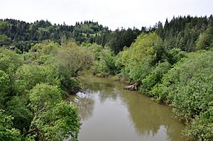
View from a bridge upstream of Myrtle Point
|
|
|
Location of the mouth of the North Fork Coquille River in Oregon
|
|
| Country | United States |
| State | Oregon |
| District | Coos County |
| City | Myrtle Point |
| Physical characteristics | |
| Main source | Coos Mountain Oregon Coast Range, Coos County 1,654 ft (504 m) 43°16′54″N 123°51′14″W / 43.28167°N 123.85389°W |
| River mouth | Coquille River Myrtle Point, Coos County 13 ft (4.0 m) 43°04′49″N 124°08′29″W / 43.08028°N 124.14139°W |
| Length | 53.3 mi (85.8 km) |
| Basin features | |
| Basin size | 154 sq mi (400 km2) |
The North Fork Coquille River is a cool river in Oregon, a state in the United States. It's about 53-mile (85 km) long and flows into the larger Coquille River. This river starts high up, about 1,700 feet (520 m) above sea level, in the Oregon Coast Range. It then flows down to just 13 feet (4.0 m) above sea level near Myrtle Point. Here, it meets up with the South Fork Coquille River to create the main Coquille River.
The River's Journey
The North Fork Coquille River is about 53 miles (85 km) long. It begins in Coos County, where many small streams come together on the side of Coos Mountain.
At first, the river flows north. Then, it turns west and south. It passes through Laverne County Park and the small town of Fairview. After that, it goes through Rock Prairie County Park.
The river then meets Middle Creek, which flows into it from the left. It continues its journey south through hills. Later, the East Fork Coquille River joins it from the left near Gravelford.
Finally, the North Fork Coquille River turns west. It winds its way to a spot just north of Myrtle Point. Here, it joins the South Fork Coquille River. Together, they form the main Coquille River, which flows west all the way to the Pacific Ocean at Bandon.
Rivers and Streams Joining the North Fork
Many smaller rivers and streams flow into the North Fork Coquille River. These are called tributaries. From where the river starts to where it ends, some of the named tributaries include:
- Little North Fork Coquille River
- North Fork Creek
- Giles Creek
- Neely Creek
- Whilley Creek
- Moon Creek
- Hudson Creek
- Swayne Creek
- Evans Creek
- Steele Creek
- Blair Creek
- Lost Creek
- Middle Creek
- Schoolhouse Creek
- Garage Creek
- Wood Creek
- Wimer Creek
- East Fork Coquille River
- Johns Creek
- Kessler Creek
- Carey Creek
- Llewellyn Creek
The River's Surroundings
The area around the Coquille River, known as its watershed, is mostly covered in forests. About 70 percent of this land is forest. These forests are often used to grow trees for timber.
Besides forests, people also use the land for farming and mining. Not many people live on the forested hillsides above the valleys.
 | Stephanie Wilson |
 | Charles Bolden |
 | Ronald McNair |
 | Frederick D. Gregory |


