Coquille River Falls facts for kids
Quick facts for kids Coquille River Falls |
|
|---|---|

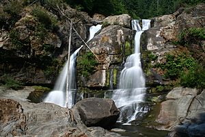
Lower tier of Coquille River Falls
|
|
| Lua error in Module:Infobox_mapframe at line 185: attempt to index field 'wikibase' (a nil value). | |
| Location | South Fork Coquille River |
| Coordinates | 42°43′03″N 124°01′17″W / 42.7173783°N 124.0214123°W |
| Type | Staircase |
| Total height | 115 ft (35 m) |
| Number of drops | 2 |
| Average flow rate |
330 cu ft/s (9 m3/s) |
Coquille River Falls is a beautiful two-part waterfall located in the northern tip of the Rogue River – Siskiyou National Forest. You can find it just east of Port Orford, on the Oregon Coast in Coos County, Oregon.
This amazing waterfall drops a total of 115 feet! It has two main sections: the upper falls is 50 feet tall, and the lower part, which is the tallest, is 65 feet tall. The two drops are about 180 feet apart from each other.
Where to Find the Falls
The water for Coquille River Falls comes from where the South Fork Coquille River meets two smaller streams, Sru Creek and Drowned Out Creek. This waterfall is the main attraction on the Coquille River Falls trailhead. A trailhead is like the starting point for a hiking path. You can find this trailhead off Forest Road 3348, which connects to National Forest Road 33.
A Bit of History
The name 'Coquille' for the waterfall and river might come from an old language called Chinook Jargon. In this language, "Scoquel" was the name for lamprey eels. These eels were very common in the river and its nearby areas.
When fur traders came to the Coos Bay area in the mid-1800s, they started using the name Coquille. They used it for both the native tribes living there and for the river itself.
A Special Natural Area
The canyons around Coquille River Falls cover about 500 acres. This area is part of something called a Federal Research Natural Area. These areas are set aside to protect special plants and animals and to allow scientists to study nature.
This particular Research Natural Area was created in 1945. It's especially important because it has a lot of Port Orford cedar trees. These special cedar trees make up about 22% of all the trees in this protected area.
How the Falls Were Formed
The waterfall itself is a continuous cliff of visible rocky outcrop. An outcrop is where solid rock sticks out of the ground. This area is surrounded by a rugged canyon. The bedrock, which is the solid rock underneath the soil, is made of sedimentary deposits. These deposits were formed a very long time ago during the Eocene era, as part of the Tyee formation.
 | DeHart Hubbard |
 | Wilma Rudolph |
 | Jesse Owens |
 | Jackie Joyner-Kersee |
 | Major Taylor |

