Middle Fork Coquille River facts for kids
Quick facts for kids Middle Fork Coquille River |
|
|---|---|

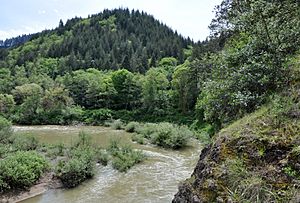
Middle Fork from bridge carrying Oregon Route 42
|
|
|
Location of the mouth of the Middle Fork Coquille River in Oregon
|
|
| Country | United States |
| State | Oregon |
| County | Douglas, Coos |
| Physical characteristics | |
| Main source | Southern Oregon Coast Range near Camas Mountain, Douglas County 1,552 ft (473 m) 43°06′17″N 123°39′51″W / 43.10472°N 123.66417°W |
| River mouth | South Fork Coquille River near Myrtle Point, Coos County 26 ft (7.9 m) 43°02′01″N 124°07′01″W / 43.03361°N 124.11694°W |
| Length | 40.3 mi (64.9 km) |
| Basin features | |
| Basin size | 310 sq mi (800 km2) |
The Middle Fork Coquille River is a river in Oregon, United States. It is about 40 miles (64 kilometers) long. This river is a "tributary," which means it is a smaller river that flows into a bigger one. The Middle Fork flows into the South Fork Coquille River.
The Middle Fork Coquille River begins high up in the Southern Oregon Coast Range. It starts near a place called Camas Mountain in Douglas County. As it flows, the river generally heads south. It goes past the area of Camas Valley, moving through the valley that shares the same name.
Then, the river makes a turn, flowing west and then north towards Remote in Coos County. After that, the Middle Fork generally flows west. It passes by the small community of Bridge. Finally, it meets the South Fork Coquille River near the town of Myrtle Point. From this meeting point, the water travels about 41 miles (66 kilometers) to where the main Coquille River flows into the Pacific Ocean at Bandon.
Oregon Route 42 is a road that runs alongside the river. It follows the river's path from Camas Valley all the way to where the Middle Fork joins the South Fork. The land around the river is mostly used for growing trees for timber and for farming. Large areas of commercial forests cover much of this region.
Smaller Rivers and Creeks
Many smaller streams and creeks flow into the Middle Fork Coquille River. These are called "tributaries." Here are some of the named tributaries, listed from the river's beginning (source) to its end (mouth):
- Estes Creek
- Lake Creek
- Cole Creek
- Lang Creek
- Wildcat Creek
- Bar Creek
- Reed Creek
- Jim Bilieu Creek
- Day Creek
- Mill Creek
- Bingham Creek
- Mystic Creek
- Twelvemile Creek
- Bear Creek
- Slater Creek
- Panther Creek
- Another Lake Creek
- Upper Rock Creek
- Slide Creek
- Sandy Creek
- Frenchie Creek
- Tanner Creek
- Belieu Creek
- Myrtle Creek
- Salmon Creek
- Big Creek
- King Creek
- McMullen Creek
- Endicott Creek
- Indian Creek
- Another Mill Creek
Fishing in the River
The Middle Fork Coquille River is home to several types of fish. You can find wild cutthroat trout here. There are also smaller groups of salmon and steelhead, which are a type of rainbow trout.
If you fish for cutthroat trout in this river, you must practice "catch and release." This means you catch the fish, but then you gently put it back into the water. The river is closed for fishing between the middle of September and the end of November. This closure helps protect the salmon when they are "spawning," which means they are laying their eggs.
 | May Edward Chinn |
 | Rebecca Cole |
 | Alexa Canady |
 | Dorothy Lavinia Brown |


