
Coos River facts for kids
Quick facts for kids Coos River |
|
|---|---|

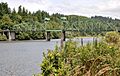
Coos River at the Chandler Bridge
|
|

Location of the mouth of the Coos River in Oregon
|
|
| Country | United States |
| State | Oregon |
| County | Coos |
| Physical characteristics | |
| Main source | Confluence of Millicoma River and South Fork Coos River Coos County, Oregon 13 ft (4.0 m) 43°22′39″N 124°05′57″W / 43.37750°N 124.09917°W |
| River mouth | Coos Bay Coos Bay, Coos County, Oregon 0 ft (0 m) 43°21′45″N 124°10′25″W / 43.36250°N 124.17361°W |
| Length | 5 mi (8.0 km) |
| Basin features | |
| Basin size | 730 sq mi (1,900 km2) |
The Coos River is a short but important river in southwest Oregon, United States. It flows for about 5 miles (8 km) into Coos Bay, which is a large estuary on the Pacific coast. An estuary is where a river meets the sea, mixing fresh and salt water.
The river starts where two main streams, the South Fork Coos River and the Millicoma River, join together. It drains a large area known for its timber (wood) production in the Southern Oregon Coast Range. The river and its main branches generally flow west from the coastal forests towards the eastern part of Coos Bay.
The Coos River is the biggest river flowing into Coos Bay. Coos Bay itself is huge, covering about 10,000 acres (4,000 ha). It is the largest estuary completely within Oregon. The river enters the bay about 15 miles (24 km) from where the bay connects to the Pacific Ocean. Many towns like Coos Bay and North Bend are located around the bay. About 30 other smaller streams also flow directly into the bay.
Most of the Coos River's watershed, which is about 730 square miles (1,890 km²), is in Coos County. A smaller part, about 147 square miles (381 km²), is in eastern Douglas County. Forests used for timber cover about 85 percent of this entire area.
The Coos River is home to several types of fish. These include Chinook and Coho salmon, shad, steelhead, and coastal cutthroat trout. Since it's hard to reach the river banks from land, people often go fishing here by boat.
Contents
Where Does the Coos River Flow?
The Coos River flows west from where the South Fork Coos River and the Millicoma River meet. As it flows, Oregon Route 241 (Coos River Highway) runs along its right side, and Coos River Road is on its left.
About 4 miles (6 km) from where the river meets the bay, Noah Creek joins the Coos River from the right. The river then curves south. Here, Vogel Creek and Lillian Creek both flow into the Coos River from the left side.
Chandler Bridge and River Branches
The river then passes under Chandler Bridge. This bridge carries Route 241 from the right side of the river to the left side. This is about 2 miles (3 km) from the river's mouth.
After the bridge, the Coos River turns west and then north as it enters Coos Bay. At this point, the river splits into two smaller channels, which are separated by a marshy area.
- The Cooston Channel is on the right. It continues north around the west side of the marsh for about 1 mile (1.6 km) until it reaches the bay.
- The channel on the left quickly joins with Catching Slough. This slough flows around the east side of the marsh and connects with the Marshfield Channel of Coos Bay.
How Much Water Flows in the Coos River?
The amount of water flowing in the Coos River changes a lot throughout the year.
- In late summer, the average flow is about 90 cubic feet per second (2.5 m³/s). This is when the river is usually at its lowest.
- In February, the average flow can be as high as 5,500 cubic feet per second (156 m³/s). This is usually the time of year with the most water.
The river's flow can also vary greatly from its average.
- The lowest recorded flow has been around 50 cubic feet per second (1.4 m³/s).
- The highest recorded flow has been an amazing 100,000 cubic feet per second (2,800 m³/s)! This shows how much the river can swell during heavy rains or floods.
Images for kids
-
Coos River at the Chandler Bridge
