
Columbia Bar facts for kids

The Columbia Bar is a special area where the Columbia River meets the huge Pacific Ocean. It's a system of sandbars and shallow spots right at the mouth of the river, between the states of Oregon and Washington. This area is about 3 miles (4.8 km) wide and 6 miles (9.7 km) long.
Contents
What Makes the Columbia Bar Dangerous?
This part of the river is known for being very tricky and dangerous for ships. When the strong river current rushes into the ocean, it often creates huge, standing waves. These waves happen because the river slows down and drops a lot of sand and dirt, and also because of the big ocean waves mixing in. The waves, wind, and strong currents make it very risky for boats of all sizes.
The river's current can be very fast, flowing westward at about 4 to 7 knots (7.4 to 13 km/h). This current often goes against the strong westerly winds and ocean swells, making the water very rough. Unlike many other big rivers that spread out into a wide delta, the Columbia River's current is focused like a "fire hose," making it even more powerful. Conditions can change from calm to life-threatening in just a few minutes!
Since 1792, about 2,000 large ships have sunk in or near the Columbia Bar. Because of how dangerous it is and how many ships have been lost, the mouth of the Columbia River is often called the "graveyard of the Pacific." This nickname shows just how many shipwrecks have happened here over the years.
Keeping the Channel Safe
To help ships pass safely, there's a special path called a navigational channel. This channel is very wide at the ocean end (about 2,640 feet or 805 meters) and gets narrower inside the river (about 600 feet or 183 meters). Big walls called jetties help guide the water and keep the channel clear. The channel is also regularly dug deeper (this is called dredging) to make sure even very large ships can get through.
On the south side of the river mouth, there's a sandy area called Clatsop Spit. On the north side, there's Peacock Spit, named after a ship called the USS Peacock that crashed there in 1841.
In 1884, after many shipwrecks, the United States Army Corps of Engineers built the south jetty. This helped keep the channel open for ships. The north jetty was added in 1914.
The Coast Guard and Bar Pilots
The Coast Guard Station Cape Disappointment in Washington is famous for working in some of the world's roughest seas. It's also home to the National Motor Lifeboat School. This is the only school in the U.S. that teaches how to rescue people in rough weather and big waves. It's known worldwide for its excellent training in handling heavy boats.
About 16 special people called "bar pilots" help guide ships safely across the Columbia Bar. They are experts at navigating these tricky waters and often board ships by helicopter to help steer them. They usually think of "the bar" as the area between the north and south jetties and Sand Island.
The Columbia Bar is one of several dangerous spots along the Pacific Northwest coast. Other tricky areas include Cape Flattery and Cape Scott. The whole region has earned the nickname "Graveyard of the Pacific" because of the thousands of shipwrecks found along its rugged coastlines.
Where to See the Bar
If you want to watch ships cross the Columbia Bar, one of the best places is the South Jetty viewing platform at Fort Stevens State Park near Warrenton, Oregon. This is also the start of the Oregon Coast Trail. For an even more amazing view, you can hike a steep 0.75-mile (1.2 km) trail to the Cape Disappointment Lighthouse at Cape Disappointment State Park in Ilwaco, Washington.

Images for kids
-
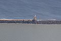
The South Jetty of the Columbia River being repaired in 2022.

