Yaquina Bay facts for kids
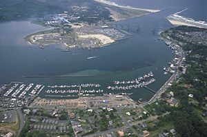
Yaquina Bay (pronounced yə-KWIN-ə) is a special coastal area in Newport, Oregon, United States. It's like a big pool of water, about 8 square kilometers (3.2 square miles) in size. This bay is connected to the Pacific Ocean, but it also gets fresh water from the Yaquina River. The famous Yaquina Bay Bridge crosses over it.
Three small towns are located near the Yaquina River and Bay: Newport (with about 9,989 people), Toledo (about 3,459 people), and Elk City (about 25 people). Yaquina Bay in Newport is a very popular spot for tourists along the Pacific Coast Highway. It's also super important for the environment and the economy of the area.
Contents
History of Yaquina Bay
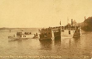
Yaquina Bay gets its name from the Yaquina Tribe. They lived along the Yaquina River for many years. In the late 1880s, when the railroad was built, many people thought Yaquina Bay would become a major trading hub for the Pacific Northwest. Things like wheat and lumber were brought to Yaquina Bay as the area grew. Businesses, especially oyster companies, started to set up shop there.
Early Explorers and Settlers
Native American tribes lived around Yaquina Bay for a long time before settlers from the east arrived. In 1856, the first ship came into Yaquina Bay. It carried supplies for block-houses up the Yaquina River. This new way to access the bay offered many benefits, especially easy shipping to and from San Francisco Bay.
Also in 1856, a doctor from the Willamette Valley was sent to work with an Indian agency in Yaquina Bay. He traveled with three other explorers, following Indian trails through the Coast Range to reach the coast.
In 1861, Captain Spencer from Washington state was one of the first settlers in Yaquina Bay. With help from a local Indian guide, Spencer found valuable oyster beds in the bay. These oysters would later attract many businesses, especially from San Francisco.
By 1866, word spread about the opportunities in Yaquina Bay. Many settlers quickly moved to the area. The town of Newport grew fast, and oyster companies and other businesses started to thrive. The growing oyster business led to the building of a wagon road from Corvallis to Yaquina Bay. This road cost about $20,000 and was 45 miles long. It was finished in 1873 and helped connect Corvallis with the coast. It also made it easier for new settlers to reach their homes.
As more people moved in and visitors came, the oyster trade in Yaquina Bay began to slow down. In 1869, a group of oystermen formed a team to protect the oyster beds. They worked hard to bring back and save the oyster communities for everyone's benefit.
Soon after Newport was established, the Yaquina Bay lighthouse was built in 1871. However, it was turned off in 1874 when the Yaquina Head lighthouse was built further north.
For many years, Yaquina Bay was a halfway point for ships traveling between San Francisco and Seattle. As more ships came and went, the number of shipwrecks in the area increased.
Past Uses of the Bay
In the past, people used Yaquina Bay for many things. They farmed oysters and fished for a living. People also dug for clams for fun. Shipping and navigation were very important. From the 1920s to the 1980s, logging also took place in the Yaquina Bay area.
Economy
Yaquina Bay and the land around it are used for many activities. These include fishing, tourism, recreation, and scientific research. In 2014, most people in Newport worked in management, business, science, and arts. A smaller number worked in natural resources, construction, and maintenance. Farming is a small part of the economy in Lincoln County, but it has grown in the last ten years. While logging used to be a big industry, it has now decreased a lot.
Fishing and Aquaculture
In 2015, Pacific Whiting (also called North Pacific Hake) was the most common fish caught by commercial fishers from Newport. Pink Shrimp brought in the most money. In 2015, the total value of commercial fishing from Newport was about $33 million.
People also fish for fun in Yaquina Bay. Popular catches include perch, rockfish, herring, salmon, clams, and crabs. Oysters are also farmed in Yaquina Bay. In 2012, about 1,172 pounds of oysters were harvested.
Fun and Tourism
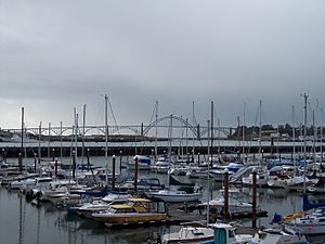
Yaquina Bay Harbor is home to many boats. These include commercial fishing boats, recreational boats, government boats, and research vessels. Tourism is a big part of the local economy. In 2012, tourism brought in $133.8 million.
Some popular places for tourists include South Beach State Park, Yaquina Bay State Recreation Site, the Oregon Coast Aquarium, and the Hatfield Marine Science Center. There are also many restaurants, shops, and attractions along the Bayfront.
Physical Geography
How the Bay Looks and Works
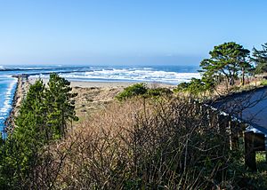
Yaquina Bay is a typical estuary. This means it gets fresh water from the Yaquina River and salty ocean water from the Pacific Ocean. The bay is kept at about 6.7 meters (22 feet) deep by dredging. However, it gets shallower upstream with sandbars and other shallow areas. The estuary is about 11.6 square kilometers at average tide. It can shrink to 9.1 square kilometers at low tide. The North and South Yaquina Jetties, which are walls built at the entrance to the ocean, were built in 1888.
The tides in Yaquina Bay change a lot. The difference between high and low tide is about 2.4 meters (7.9 feet). The water mixes strongly near the mouth of the bay. In summer (June to October), the water mixes well. In winter (November to May), the water layers more, with fresh water on top of salt water. Because of these changes, the saltiness (salinity) of the bay varies a lot. At the mouth of the bay, the average saltiness is 34 parts per thousand. Upriver, it can be zero.
The Yaquina River is 95 kilometers (59 miles) long. It starts in the Central Oregon Coast Range and flows past several towns before reaching Yaquina Bay. The river brings important nutrients to the bay and supports many different living things.
Sand and Mud in the Bay
The sand and mud in Yaquina Bay come from rocks in the Central Oregon Coast Range. They also come from old ocean and estuary deposits. These sediments settle in three main areas: ocean areas, river areas, and a mix of both. Ocean sediments are found near the bay's entrance. They are usually sandy. River sediments are found further upstream and are coarser. The mixed area has sediments from both the ocean and the river.
The last time sediment build-up was measured was in 1936. It was estimated that about 23 centimeters (9.1 inches) of sediment built up each year. However, this changes with the seasons. More sediment builds up in winter and early spring. This is when there is more rain and river water, and when ocean currents bring sand from the south. In summer, less sediment builds up.
When the water in the bay mixes a lot, it stirs up more sediment. This makes the water cloudy. The water is often cloudiest in the summer when river flow is low.
How the Bay Was Formed
Yaquina Bay was formed about 2.2 million years ago. It was created by a lot of sediment building up and the land sinking. The rocks in this area are mostly sandstone, siltstone, and mudstone. The oldest rocks found in the Coast Range and Yaquina Bay are about 40-60 million years old. The seafloor west of Oregon is still spreading, and there is evidence that one part of the Earth's crust is sliding under another along the coast of Washington and Oregon.
Biology of Yaquina Bay
Yaquina Bay has many different places for animals and plants to live. These include beds of eelgrass, mudflats, and sandflats. Some areas are covered by water all the time (subtidal areas). Mudflats and sandflats are usually covered at high tide and exposed to the air at low tide.
Life in Yaquina Bay
Beds of native eelgrass (Zostera marina) and invasive eelgrass (Zostera japonica) grow separately. They provide special homes for certain creatures. Many birds live in Yaquina Bay, using the eelgrass and mudflats. These include gulls, ducks, shorebirds, crows, geese, egrets, pelicans, and cormorants.
Mud shrimp also live in the mudflats. They are very important for moving nutrients around in the bay. When mud shrimp dig burrows, they bring oxygen deeper into the mud. This oxygen helps tiny living things (microbes) in the mud. Mud shrimp also help carbon and nitrogen move in and out of the mud. Some tiny plants called diatoms (a type of phytoplankton) can be found on the sediments of Yaquina Bay's wetlands. These diatoms also help with nutrient cycling.
Another type of habitat is formed by native Olympia oysters (Ostrea lurida). These oysters used to be very common in Yaquina Bay. They create hard surfaces in the bay and also filter the bay water. People also ate these oysters. In fact, the oyster fishing was one reason why people settled at the mouth of Yaquina Bay.
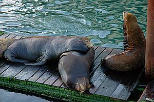
In the deeper, subtidal areas, you might see marine mammals like harbor seals and California sea lions. Most of the sea lions in the bay are male. They move through the bay but often spend time near the Bayfront or resting on docks. This might be because there is more food or it feels safer there.
Some fish found in Yaquina Bay include English sole, sculpin, river lamprey, lingcod, anchovies, Pacific herring, sturgeon, flounder, and salmon. Clams and Dungeness crabs also live in the bay and are popular for recreational fishing.
The Estuary as a Nursery
Yaquina Bay is a very important place for many species to lay their eggs and for their young to grow up. Many Pacific Herring and bay goby larvae (baby fish) are found here. Other baby fish like sculpin, anchovy, smelt, clingfishes, cod, stickleback, pipefish, prickleback, gunnels, sandlance, rockfish, greenlings, lumpfish, and flounder are also present.
Even though many types of baby fish are in the estuary, only the Pacific herring relies on the estuary for spawning and growing into adults. Yaquina Bay also provides a nursery for young English sole. Several types of young salmon, including chum, coho, and chinook, pass through Yaquina Bay as they grow. They often move from shallower to deeper waters as they get bigger.
Chemistry of Yaquina Bay
The water chemistry in Yaquina Bay changes because of daily tides, river sediment coming in, summer upwelling from the ocean, and living things in the bay.
Tides and Mixing
Yaquina Bay has two high tides and two low tides each day. The difference between high and low tide is usually between 1.9 and 2.5 meters (6.2-8.2 feet). When ocean water flows in, it changes how salty the bay is. This salty water can reach up to 21.8 kilometers (13.5 miles) up the river. Daily tides also affect how well the water mixes.
When ocean water comes in, it brings important nutrients like nitrogen and phosphorus into the bay. When the water mixes, the saltiness, chemical levels, and amount of suspended sediment change. These changes affect how much life can grow in the bay. Yaquina Bay has a lot of plant growth all year. This is because it has high levels of dissolved oxygen and cool water from the tides flushing the bay.
Nutrients in the Bay
Nutrients are like food for the tiny plants and animals in the bay. The main sources of nutrients for Yaquina Bay change with the seasons. In drier seasons, the ocean brings in most of the nutrients. In wetter seasons, the river is the main source, as its flow can be five times higher.
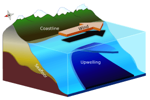
For example, during summer, ocean water that comes up from the deep (called upwelling) brings a lot of nutrients into the bay. These nutrients are enough to support a lot of plant growth during the summer months.
Oxygen in the Water
The amount of dissolved oxygen (DO) in the water is very important for living things. In Yaquina Bay, DO levels can sometimes be low, almost to a point where it's hard for some animals to breathe. This can happen when cool, upwelled ocean water with low DO comes into the bay. The ocean's influence on DO levels can reach about 10 kilometers (6.2 miles) upriver. Further upriver, DO levels usually decrease when the water temperature increases.
Chlorophyll a and Upwelling
Chlorophyll a (Chl a) is a green pigment in plants, and its levels show how much tiny plant life (like algae) is in the water. Chl a levels change with the seasons, especially when ocean water comes in during summer upwelling. Oregon estuaries usually have low Chl a levels. But when high amounts of Chl a are brought into the bay, the dissolved oxygen levels also increase during high tide.
Upwelling
Summer upwelling along the Oregon coast is when cold, nutrient-rich water from deep in the ocean rises to the surface. This event, along with less rain and river water, and more sunlight, all cause the bay's chemistry to change with the seasons.
Environmental Concerns
Coastal Dangers in Yaquina Bay
Like any coastal area, Yaquina Bay faces natural dangers. Especially in the Pacific Northwest, coastlines are affected by big waves, storm surges, strong currents, wind, and rain. Yaquina Bay experiences these impacts seasonally, with winter usually being the most intense time. Storms and rain increase, which leads to more water running off the land. This also causes waves and currents to change the shape of the coastline.
Erosion is a problem for Yaquina Bay and the entire Oregon Coast. The sediments in Yaquina Bay are made of sandstone, siltstone, and clay-containing mudstone. These soft sediments contribute to how much the coast erodes each year. However, waves are the main cause of erosion. Waves run parallel to the beach. As the wind gets stronger, the waves get more powerful and taller, causing a lot of damage to beaches. Also, currents moving along the coast shift sand, either adding or removing it from certain areas. This has been very clear around the Yaquina Jetty, where sand builds up dramatically in winter due to strong currents.
In 2002, researchers and local groups worked together to figure out how vulnerable the coast was to future dangers. They studied Yaquina Bay because it's so important for tourism, businesses, and shipping. This study helped identify problem areas and showed businesses how to adapt to changing conditions to prevent future damage.
 | Bessie Coleman |
 | Spann Watson |
 | Jill E. Brown |
 | Sherman W. White |


