Toledo, Oregon facts for kids
Quick facts for kids
Toledo, Oregon
|
|
|---|---|

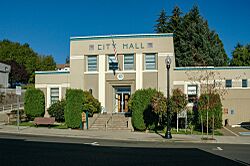
The city hall building in Toledo
|
|

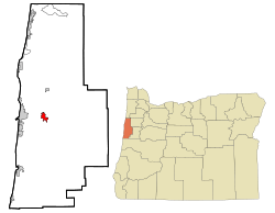
Location in Oregon
|
|
| Country | United States |
| State | Oregon |
| County | Lincoln |
| Incorporated | 1893, 1905 |
| Area | |
| • Total | 2.39 sq mi (6.20 km2) |
| • Land | 2.16 sq mi (5.59 km2) |
| • Water | 0.23 sq mi (0.61 km2) |
| Elevation | 180 ft (50 m) |
| Population
(2020)
|
|
| • Total | 3,546 |
| • Density | 1,643.19/sq mi (634.53/km2) |
| Time zone | UTC-8 (PST) |
| • Summer (DST) | UTC-7 (PDT) |
| ZIP code |
97391
|
| Area code(s) | 541 |
| FIPS code | 41-74000 |
| GNIS feature ID | 2412076 |
| Website | www.cityoftoledo.org |
| Coordinates and elevation from the Geographic Names Information System of the United States Geological Survey | |
Toledo is a city in Oregon, located on the Yaquina River. It's found in Lincoln County and is along U.S. Route 20. In 2020, about 3,546 people lived there. Toledo was even a finalist for the All-America City Award in 2009!
Contents
History of Toledo
Early Settlement
Toledo was first settled by European-Americans in 1866. This happened when John Graham, his son Joseph, and William Mackey claimed land. They used a law called the Homestead Act of 1862, which allowed people to get land for free if they lived on it and improved it.
The place was first called "Graham's Landing." Two years later, a post office was opened. Joseph D. Graham, John's son, named the post office "Toledo." He chose this name because he missed his hometown of Toledo, Ohio. William Mackey became the first postmaster.
Becoming a County Seat
In 1893, Toledo became the main city, or county seat, for the new Lincoln County. The city officially became a city (incorporated) in 1893 and then again in 1905. Charles Barton Crosno was the first mayor.
However, in 1953, the county seat moved from Toledo to Newport. Also, a new and improved U.S. Route 20 was built that went around Toledo. This meant many businesses moved to Newport, which was a tough time for Toledo.
Lumber and Pulp Mills
In 1918, the Port of Toledo rented land for a sawmill. This mill was meant to cut wood for airplane frames during World War I. But the war ended before the mill could start making planes.
Later, in 1920, a company called Pacific Spruce Corporation bought the mill. By 1922, this mill was processing logs that came by train or floated down the Yaquina River. In 1952, another big company, Georgia-Pacific, took over the mill. They changed it into a pulp mill by 1957, which makes material for paper.
The Toledo Incident of 1925
In 1925, the Pacific Spruce Corporation decided to hire Japanese workers. These workers were going to sort lumber at their sawmill. The company told local workers that only the Japanese crew would work the night shift. Local business owners were not happy about Japanese workers coming to the community.
A few days after the Japanese workers arrived, they left town. A year later, a worker named Tamakichi Ogura filed a lawsuit. He said that some people had treated him unfairly and caused him to leave. After a trial, the jury agreed with Ogura. They awarded him money for damages and court costs. This event is written about in a book called The Toledo Incident of 1925.
Butter Tub Production
From 1927 to 1944, a company from Chicago called Creamery Package Manufacturing Company had a large sawmill in Toledo. This mill made parts for butter tubs. They produced up to two million spruce butter tubs each year! These tubs were shipped in pieces by train to factories in the Midwest. Most of them were designed to hold 63 pounds of butter.
Geography and Climate
City Area
Toledo covers about 2.41 square miles (6.24 square kilometers). Most of this area is land, about 2.18 square miles (5.65 square kilometers). The rest, about 0.23 square miles (0.60 square kilometers), is water.
Weather in Toledo
Toledo has a mild climate. The warmest month is usually August, with average high temperatures around 72.9°F (22.7°C). The coldest months are January and December, with average low temperatures around 37-38°F (3°C). Toledo gets a lot of rain, especially in winter. The wettest months are November and December. Snowfall is very rare, with only about an inch per year.
Population Information
| Historical population | |||
|---|---|---|---|
| Census | Pop. | %± | |
| 1900 | 302 | — | |
| 1910 | 541 | 79.1% | |
| 1920 | 678 | 25.3% | |
| 1930 | 2,187 | 222.6% | |
| 1940 | 2,288 | 4.6% | |
| 1950 | 2,323 | 1.5% | |
| 1960 | 3,053 | 31.4% | |
| 1970 | 2,818 | −7.7% | |
| 1980 | 3,151 | 11.8% | |
| 1990 | 3,174 | 0.7% | |
| 2000 | 3,472 | 9.4% | |
| 2010 | 3,465 | −0.2% | |
| 2020 | 3,546 | 2.3% | |
| U.S. Decennial Census | |||
Population in 2010
In 2010, there were 3,465 people living in Toledo. There were 1,331 households and 907 families. The city had about 1,589 people per square mile.
About 33.9% of households had children under 18 living with them. Many households were married couples living together (47.5%). The average household had 2.60 people. The average family had 3.02 people.
The average age of people in Toledo was 37.6 years old. About 24.8% of residents were under 18. About 11.8% were 65 years or older. There were slightly more females (51.3%) than males (48.7%) in the city.
Education in Toledo
Toledo has two public schools. They are part of the Lincoln County School District.
- Toledo Elementary School serves students from kindergarten to 6th grade.
- Toledo High School serves students from 7th to 12th grade. It combines junior high and high school levels.
Transportation in Toledo
Railroad Connections
Toledo is the end point of a Portland and Western Railroad line. This railroad route was once part of the Oregon Pacific Railroad. It was finished in 1885, connecting Yaquina City through Toledo to Corvallis. Later, in 1887, it linked Toledo to Albany with a very long bridge over the Willamette River.
The city also has a port authority, which manages the port. There is also the Toledo State Airport.
Railroad History Museum
The history of railroads in the area is kept alive at the Yaquina Pacific Railroad Historical Society (YPRHS) in Toledo. You can see two historic locomotives from the Georgia-Pacific company there.
- One is called the "One Spot." It's a steam locomotive built in 1922. This train worked only in Lincoln County from 1922 to 1959.
- The other is a diesel locomotive built in 1951. It was donated to the museum in 2016.
- The museum also has a restored Southern Pacific 1923 Railway Post Office / Baggage car.
Oregon's First Brick Train Station
On August 3, 1893, Toledo became the first city in Oregon to have a train station (depot) made of brick. The citizens of Toledo wanted a proper station. They agreed to pay $250 and provide labor for the building. In return, the Oregon Pacific railroad agreed to build a brick depot within 60 days. The station was 20 feet by 60 feet.
The depot was made bigger and covered with stucco by the Southern Pacific Railroad in 1922-1923. Sadly, the depot was torn down in 1961 to make way for street improvements.
See also
 In Spanish: Toledo (Oregón) para niños
 | Delilah Pierce |
 | Gordon Parks |
 | Augusta Savage |
 | Charles Ethan Porter |

