Yaquina River facts for kids
Quick facts for kids Yaquina River |
|
|---|---|

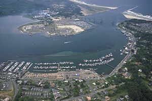
Yaquina Bay, where the Yaquina River meets the Pacific Ocean
|
|
|
Location of the mouth of the Yaquina River in Oregon
|
|
| Country | United States |
| State | Oregon |
| County | Benton and Lincoln |
| Physical characteristics | |
| Main source | near Summit, Benton County, Central Oregon Coast Range 44°44′57″N 123°36′06″W / 44.74917°N 123.60167°W |
| River mouth | Yaquina Bay Newport, Lincoln County 3 ft (0.91 m) 44°36′44″N 124°01′04″W / 44.61222°N 124.01778°W |
| Length | 59 mi (95 km) |
| Basin features | |
| Basin size | 252 sq mi (650 km2) |
The Yaquina River (pronounced yə-KWIN-ə) is a stream about 59 miles (95 km) long. It flows on the Pacific coast in the state of Oregon, United States. This river helps drain an area of the Central Oregon Coast Range mountains. It flows west towards Newport.
Contents
Where Does the Yaquina River Start and End?
The Yaquina River begins in the mountains west of Corvallis. Its source is located along the border between Benton and Lincoln counties. The river first flows south, then generally west. It takes a very winding path, like a snake.
It passes by several towns, including Eddyville, Chitwood, Toledo, and Elk City. Finally, the Yaquina River flows into the Pacific Ocean at Yaquina Bay. This bay is a wide estuary, which is where a river meets the sea. It is located near the city of Newport.
How the River Changed Over Time
Long ago, when the sea level was much lower than it is today, the Yaquina River reached even further. It extended all the way to a place called Stonewall Bank. This bank is now split by a rocky channel under the ocean.
Bridges and Important Places Along the River
Several important roads and places are found along the Yaquina River.
Roads and Bridges Crossing the River
U.S. Route 20, a highway connecting Corvallis and Newport, follows the river for a good distance. It starts near Eddyville, where Little Elk Creek joins the Yaquina River. The highway continues downstream past Chitwood.
Near the mouth of Yaquina Bay, the river flows under the famous Yaquina Bay Bridge. This large bridge carries U.S. Route 101, another major highway. Another interesting bridge over the river is the Chitwood Covered Bridge, located in Chitwood.
Science and Nature Centers Near Yaquina Bay
There are important scientific centers located along Yaquina Bay. The National Oceanic and Atmospheric Administration (NOAA) has its Pacific Marine Center here. Also, the Hatfield Marine Science Center is located along the bay. These centers study the ocean and marine life.
Right next to the Hatfield Center, you can find the Oregon Coast Aquarium. This is a popular place to learn about animals that live in the ocean. The Yaquina Bay Lighthouse is also nearby. It is part of the Yaquina Bay State Recreation Site and stands on the coast close to where the river meets the ocean.
Fishing and Wildlife in the Yaquina River
The Yaquina River and Yaquina Bay are great places for fishing and seeing different kinds of marine life.
Ocean and Bay Fishing Opportunities
Many fishing boats operate out of Newport. They take people out into the ocean to catch fish like halibut and salmon. Inside Yaquina Bay itself, you can find many species. These include cabezon, striped perch, rockfish, greenling, salmon, sturgeon, herring, and crabs.
River Fishing and Access
Upstream from the bay, the river is home to different types of fish. You can find populations of salmon, steelhead (a type of rainbow trout), and cutthroat trout. People also fish from the river banks in some areas. Small boats are used for fishing in the river and bay. There are special ramps available to launch boats along the lower part of the river and in the bay.
Tributaries of the Yaquina River
Many smaller streams and creeks flow into the Yaquina River. These are called tributaries. They add water to the main river as it flows towards the ocean.
Upper River Tributaries
Starting from the source of the Yaquina River and moving downstream, the first named tributaries include:
- Bailey Creek
- Little Yaquina River
- Splide Creek
- Humphrey Creek
- Young Creek
- Felton Creek
- Davis Creek
- Randall Creek
- Stony Creek
- Bryant Creek
- Buttermilk Creek
Middle River Tributaries
Further downstream, more creeks join the Yaquina River:
- Bales Creek
- Trout Creek
- Little Elk Creek
- Eddy Creek
- Peterson Creek
- Hayes Creek
- Whitney Creek
- Crystal Creek
- Cougar Creek
- Thornton Creek
- Trapp Creek
- Simpson Creek
- Sloop Creek
- Martin Creek
- Bear Creek
- Little Carlisle Creek
- Carlisle Creek
- Big Elk Creek
- Blair Creek
- Abbey Creek
- Mill Creek
Lower River and Bay Tributaries
Along the lower parts of the river and near Yaquina Bay, these streams and sloughs (slow-moving channels) flow in:
- Olalla Slough
- Depot Slough
- Babcock Creek
- Montgomery Creek
- Nute Slough
- Boone Slough
- Blind Slough
- Flesher Slough
- Johnson Slough
- Poole Slough
- McCaffery Slough
- Parker Slough
- King Slough
- Sallys Slough
 | Sharif Bey |
 | Hale Woodruff |
 | Richmond Barthé |
 | Purvis Young |


