
Columbia River Estuary facts for kids
Quick facts for kids Columbia River Estuary |
|
|---|---|

Aerial image of the mouth of the Estuary
|
|
 |
|
| Physical characteristics | |
| Main source | Columbia River Columbia Lake, BC, Canada |
| River mouth | Pacific Ocean Cape Disappointment State Park / Fort Stevens State Park 46.2536° N, 124.0585° W |
The Columbia River Estuary is a special place where the Columbia River meets the Pacific Ocean. It's located on the border between Oregon and Washington states in the United States. For thousands of years, the Chinook Native Americans lived here. Later, in 1788, explorers from other countries arrived. This area is full of amazing plants and animals, both in the water and on land. Many groups work hard to protect this important natural area.
Contents
What is the Columbia River Estuary?
The Estuary of the Columbia River is the part of the river where its fresh water mixes with the salty water of the ocean. It stretches inland all the way to the Bonneville Dam. This dam is the furthest point where you can still notice the water levels changing because of the ocean's tides.
Who are the First Nation Peoples of the Estuary?
The Columbia River was called hayásh-tsəqʷ by the Chinookan people, which means “great water.” For centuries, it was a busy trading center for Native Americans in the Pacific Northwest. We know that people have lived in this area for about 10,000 years. Today, the traditional owners of the Columbia River Estuary are the Chinook Native Americans. They used to live along a large part of the northern shore.
The Chinook people were very successful. Their economy mainly focused on trading salmon during the summer. They were famous for their fishing method called seining. This involved dragging a weighted net into the river and pulling it back to shore to catch salmon. In winter, when they moved to villages along the Columbia's smaller rivers, they hunted game and fowl. They also gathered local plants for food.
Chinook Mythology: How the Estuary Was Created

Long ago, before humans, animal spirits ruled the world. A huge beaver named Wishpoosh lived in Keechelus Lake. He would often harm smaller creatures. The coyote god of the Columbia region, Speelyei, decided to stop him.
Wishpoosh became very angry. He burst the banks of the lake, causing a flood that formed a new large lake in the Kittitas Valley. The fight continued, and Wishpoosh's fury was so great that the edges of this new lake also broke. This flooded the area around Yakima, WA.
The battle went on. The new lake grew, reaching west to where the Yakima, Snake, and Columbia Rivers met. This area had been blocked by the Umatilla Highlands. Now, this huge lake had its eastern border at the Umatilla Highlands and its western border at the Cascade Range.
The fighting didn't stop. Eventually, the giant Cascade Mountains were broken through. The water that had built up rushed to the sea, creating the Columbia River Estuary. This is how the “Great Water” got its path we see today. Speelyei finally defeated Wishpoosh out in the ocean, and the beaver's body washed up south of the Estuary.
Colonization and Treaties
After European settlers arrived, the Chinook people signed a treaty with Anson Dart in 1851. This treaty was meant to allow them to stay on their traditional lands at the Estuary. They did not want to be moved to a reservation east of the Cascade Mountains. However, the US Congress never approved this treaty. This led to many conflicts and legal battles that started in 1899 and are still ongoing today.
When Was the Estuary Discovered?

In 1788, a fur trader named John Meares came very close to finding the Estuary. But his ship couldn't get past the rough waves at the river's mouth. He thought there wasn't a river there at all. He did name the northern point Cape Disappointment. The Chinook people called it kah’see'.
In 1792, Robert Gray, an American fur trader, successfully crossed the difficult river bar in his ship, the Columbia Redeviva. He became the first non-Native American explorer to enter the estuary. He named the estuary Gray's Bay and the river the Columbia River. For a while, there was some debate about who truly discovered the estuary. Today, it is clear that Robert Gray was the first.
What is the Geology of the Estuary?

The Columbia River Estuary is located in a valley. This valley was carved into old ocean sediments and volcanic rocks from the Tertiary period. The estuary gets a lot of water from the Cascade Range, which are mountains to its east. These mountains trap rain and moisture. Sediments from the Pleistocene and Holocene eras have filled the valley and continue to do so. These sediments greatly shape the estuary's look.
Plate Tectonics and Earthquakes
The estuary is part of the North American tectonic plate. It sits on an active continental margin, which is where two plates meet. The Juan de Fuca plate is slowly sliding underneath the North American plate. This process, called subduction, has caused volcanoes like Mt St Helens in the Cascade Range to erupt.
Also, the land around the estuary has tilted. The coastal area has lifted up, while some inland parts of Washington and Oregon have sunk down into a trough. This tilting, along with volcanic activity, affects how much sediment flows into the Estuary. Compared to other estuaries, the Columbia River Estuary receives less sediment.
Because of these tectonic movements, the estuary area sometimes experiences small deep-focus earthquakes.
What Animals and Plants Live Here?

The Columbia River Estuary is home to an incredible variety of life. It is a very biodiverse system. At different times in their lives, over 70 species of fish live here. Hundreds of bird species, and many reptiles, mammals, and amphibians also call it home. The exact number of tiny invertebrate species has not yet been counted. You can find a full list of animal species on the Estuary Partnership website here.
How is the Estuary Being Conserved?
Even though the Estuary is full of life, human activities have greatly changed it over time. These changes have affected both the land and water in and around the estuary. As a result, the local variety of plants and animals is at risk. Many species depend on the estuary's natural and diverse environment.
In the past, the main human activities that changed the estuary were building jetties, creating dikes (walls to control water), and dredging (removing mud from the riverbed). These actions have led to huge losses of marshes and other shoreline habitats. They have also reduced the amount of water that moves with the tides and how well the water mixes. More than 50% of all wetlands in the estuary's history have been lost. Over 70% of this loss was due to diking and filling. Experts believe that if the estuary had remained untouched, it could support up to 138 times more plant-eating animals than it does today.
Two conservation groups, the Lower Columbia Estuary Partnership (LCEP) and the Columbia River Estuary Study Taskforce (CREST), have been working for decades to protect the environment. They do many different things, from planning and carrying out habitat restoration to monitoring the environment and mapping the area. Together, they have completed many projects to help keep the estuary's ecosystem healthy.
Batwater Station Floodplain Restoration Project
This project was run by LCEP. It reconnected 26 acres (11 ha) of marshes to the Columbia River Estuary. This helped bring back habitats used by endangered fish species. It also reintroduced local plants. Structures for beavers were installed, and land was replanted to encourage natural environmental processes.
Louisianna Swamp Restoration
Also run by LCEP, this project reconnected 35 acres (14 ha) of habitat to the estuary. The swamp used to be surrounded and fish couldn't get into it. The project allowed tidal waters to flow in and out, helping to restore natural processes. This was good for marine animals. Also, many invasive plants were removed and replaced with local plants. These native plants now support many animals that live on the land around the estuary.
Tourism and Recreation
The land around the estuary has many hiking trails for visitors. Local companies also offer boat tours around the area, allowing people to explore and enjoy the beautiful scenery.
Images for kids
-
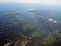
Aerial image of the mouth of the Estuary
-
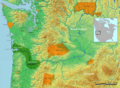
Map of Chinook tribal territory
-
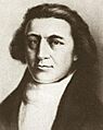
Robert Gray
-
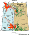
The Juan de Fuca Plate, black arrows indicate the direction of subduction
-
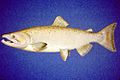
Chinook salmon
