
Gladstone, Oregon facts for kids
Quick facts for kids
Gladstone
|
||
|---|---|---|
| Gladstone, Oregon | ||

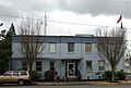
Fire and police station, located in Gladstone's downtown
|
||
|
||
| Motto(s):
Home of the Pow Wow Tree
|
||

Location in Oregon
|
||
| Country | United States | |
| State | Oregon | |
| County | Clackamas | |
| Incorporated | 1911 | |
| Area | ||
| • Total | 2.49 sq mi (6.45 km2) | |
| • Land | 2.40 sq mi (6.21 km2) | |
| • Water | 0.09 sq mi (0.24 km2) | |
| Elevation | 89 ft (27 m) | |
| Population
(2020)
|
||
| • Total | 12,017 | |
| • Density | 5,011.26/sq mi (1,934.82/km2) | |
| Time zone | UTC-8 (Pacific) | |
| • Summer (DST) | UTC-7 (Pacific) | |
| ZIP code |
97027
|
|
| Area code(s) | 503 | |
| FIPS code | 41-29000 | |
| GNIS feature ID | 2410593 | |
| Website | City of Gladstone | |

Gladstone is a city in Clackamas County, Oregon, United States. In 2020, about 12,017 people lived there. It is a suburban community about 12 miles (19 km) south of Portland. Gladstone is located where the Clackamas and Willamette rivers meet.
Gladstone has been important for many cultural and social events. It hosted the very first Clackamas County Fair and the Oregon State Fair. Both events later moved to bigger places. Famous people like Secretary of State William Jennings Bryan and presidential candidate Theodore Roosevelt gave speeches in the city.
Contents
History of Gladstone
Early Native American Life
Before European settlers arrived, several Native American groups lived in the area that is now Gladstone.
In 1804, President Thomas Jefferson sent the Lewis and Clark Expedition to explore the western lands. Even though the expedition only passed near Gladstone, native people like the Kalapuya and Clackamas people told them about the area.
Later, explorers and traders brought diseases like cholera and smallpox. These diseases greatly reduced the native population.
As Oregon City was founded, more European settlers moved to the area. They asked the government to move the local natives so they could use the land for farming and homes. The government created a reservation for the natives. The land where Gladstone is now was then used for new development.
As of 2014, a large maple tree called the Pow Wow Tree is the only remaining sign of the early natives. It is listed as an Oregon Heritage Tree. The tree still stands on Clackamas Boulevard. It is said to have been a meeting place for different native tribes. These tribes, mainly the Clackamas and Multnomahs, met there to trade, discuss community matters, and hold wedding ceremonies. In 1860, the Pow-Wow Tree was the site of the first Clackamas County Fair. The next year, it was the entrance to the first Oregon State Fair. In 1937, the tree was celebrated with the Gladstone Pow-Wow Festival.
First Settlers
The first homes in the area were built by people who received land through the Donation Land Claim Act. The Cason and Rinearson families were the first to get land claims in Gladstone. Peter M. Rinearson and his family owned land between Jennings Lodge and the Clackamas River. Fendal Cason, who came to Oregon in 1843, owned a similar amount of land nearby.
Unsuccessful Early Towns
Before Gladstone was officially founded, some small settlements were started nearby. However, many of them did not last. This was often due to natural disasters like fires and floods.
One such town was Linn City. It was settled in 1843 by Robert Moore. He built mills and warehouses. But in 1861, a fire destroyed some buildings. Then, the Great Flood of 1862 wiped out the rest.
Another town was Canemah, near the Willamette Falls. Canemah grew until the same great flood in 1861 swept most of it away. Even after rebuilding, its importance for river trade ended in 1873. This was when the Willamette Falls Locks were completed. Ships no longer needed to stop there. The town officially became part of Oregon City in 1929.
Founding of Gladstone

Gladstone was founded by Judge Harvey Cross in 1889. It officially became a city on January 10, 1911. The city was named after William Ewart Gladstone, who was a Prime Minister of the United Kingdom.
Judge Cross planned the city's first streets. His home was built in the 1840s by Fendal Cason. Cross bought it in 1862. Today, a plumbing service called Mr. Rooter is in that spot. There is also a small park named after Judge Cross. It is located where one of the Native American tribes used to camp.
The Chautauqua Movement
In 1894, the Chautauqua movement came to Gladstone. This movement brought education and entertainment to communities. Judge Cross agreed to let Gladstone Park be used for this event for fifty years. He was convinced by author Eva Emery Dye that it would help the city.
The Willamette Valley Chautauqua Association held its first annual summer event from July 24–26, 1894. It offered performances, lectures, and concerts. This event happened every year. Gladstone's Chautauqua Park became the third-largest permanent Chautauqua park in the United States.
In 1896, William Jennings Bryan spoke to 6,000 people at the park. He gave his famous lecture "The Prince of Peace." He talked about how Christian beliefs could lead to peace and equality.
Over time, with radio and better transportation, fewer people attended Chautauqua events. In 1927, the Willamette Valley Chautauqua Association went out of business. Judge Cross died on August 7, 1927. Soon after, Gladstone Park and its buildings were sold to the Western Oregon Conference of Seventh-day Adventists.
Geography
Gladstone covers an area of about 2.48 square miles (6.42 square kilometers).
Neighboring Communities
Gladstone is surrounded by several other communities:
- Oregon City, the county seat, is to the south. The Clackamas River mostly separates them.
- West Linn is to the west, separated by the Willamette River.
- Oak Grove is an unincorporated area next to Gladstone.
- Jennings Lodge is another unincorporated area between Oak Grove and Gladstone.
- Oatfield is an unincorporated area north of Gladstone.
- Clackamas is an unincorporated area to the northeast.
- Johnson City is a very small city northeast of Gladstone, with about 500 residents.
Gladstone, Oregon City, West Linn, and Milwaukie are all part of the larger Portland metropolitan area. These cities together have a population of over 100,000 people. Even though Gladstone is close to Milwaukie, they do not share a border.
Main Roads and Street Names

Gladstone is bordered by rivers on two sides. This means there are only two main roads in and out of the city. Interstate 205 runs north–south along the eastern edge. McLoughlin Boulevard (Oregon Route 99E) runs north–south through the western side.
Surveyor Sidney Smyth suggested that Judge Harvey Cross name many Gladstone streets after American colleges. Examples include University of California, Berkeley and Cornell University. Some streets are also named after UK dukes, earls, and universities. Portland Avenue is the only main street that does not follow this naming rule. It was named after an electric streetcar line that once ran along it, carrying passengers between Gladstone and Portland.
Climate
The average temperature in Gladstone is about 54.4°F (12.4°C). The city gets about 46.3 inches (1176 mm) of rain each year. Gladstone has a warm-summer Mediterranean climate. This means it has warm, dry summers and mild, wet winters.
Population Information
| Historical population | |||
|---|---|---|---|
| Census | Pop. | %± | |
| 1920 | 1,069 | — | |
| 1930 | 1,348 | 26.1% | |
| 1940 | 1,629 | 20.8% | |
| 1950 | 2,434 | 49.4% | |
| 1960 | 3,854 | 58.3% | |
| 1970 | 6,254 | 62.3% | |
| 1980 | 9,500 | 51.9% | |
| 1990 | 10,152 | 6.9% | |
| 2000 | 11,438 | 12.7% | |
| 2010 | 11,497 | 0.5% | |
| 2020 | 12,017 | 4.5% | |
| Sources: | |||
In 2010, there were 11,497 people living in Gladstone. There were 4,540 households and 3,009 families. The city had about 4,779 housing units. Most of the people were White (89.2%). Other groups included African American (0.9%), Native American (1.0%), Asian (1.6%), and Pacific Islander (0.4%). About 8.7% of the population was Hispanic or Latino.
Arts and Culture
The annual Gladstone Community Festival and parade happens on the first weekend of August. It celebrates Gladstone's past as a popular Chautauqua destination. The festival is held in Max Patterson Memorial City Park. KRYP is a Spanish-language FM radio station that broadcasts from the city.
Public Services
Schools
Gladstone is served by the Gladstone School District. This district includes John Wetten Elementary School, Kraxberger Middle School, and Gladstone High School. In 2006, voters approved money for about $40 million worth of construction work on the three schools. Most of the money (about $26 million) was used to remodel the high school.
Library

Clackamas County runs a library in Gladstone. It is part of the Library Information Network of Clackamas County. In 2012, the city council approved plans for a new $10 million library. However, groups like Save Gladstone blocked the funding. They wanted voters to approve the project specifically. The city then put a new measure on the November 2014 ballot for a $6.4 million option. Plans were put on hold when the COVID-19 pandemic caused material costs to rise too high.
Parks
Gladstone has 14 parks and recreational areas, even though it is a small city. Some of these parks include: Abernethy Lane Trail, Cross Park, Dahl Beach, Dierickx Field, Gladstone Nature Park, Glen Echo Wetland, High Rocks Park, Max Patterson Memorial City Park, Meldrum Bar Park, Nick Shannon Park, Ridgegate Tracts, Robin Hood Park, Salty Acres Wetlands and Stocker Park.
Public Transportation
Gladstone is part of the TriMet transportation district. Bus services in the city are provided by TriMet bus routes 32-Oatfield, 33-McLoughlin/King Road, 34-Linwood/River Road, and 79-Clackamas/Oregon City. There is also the 99-Macadam/McLoughlin express route during rush hour.
Notable People
American labor activist Liz Shuler grew up in Gladstone. She became the Secretary-Treasurer of the AFL–CIO. She was the first woman and, as of 2009, the youngest person to hold that position. Actor Clifton James also grew up in Gladstone and died there. James was in the James Bond films Live and Let Die (1973) and The Man with the Golden Gun (1974). He was also in Cool Hand Luke (1967).
Images for kids
-
City Hall and municipal court

See also
 In Spanish: Gladstone (Oregón) para niños
