Clackamas River facts for kids
Quick facts for kids Clackamas River |
|
|---|---|
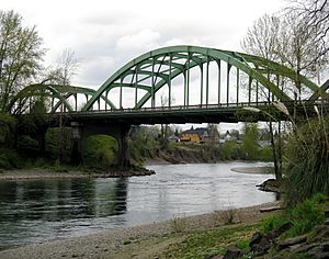
Clackamas River Bridge at Oregon City
|
|
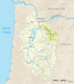
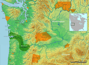
Map showing the Clackamas River highlighted within the Willamette River watershed
|
|
|
Location of the mouth of the Clackamas River in Oregon
|
|
| Country | United States |
| State | Oregon |
| Counties | Marion and Clackamas |
| Physical characteristics | |
| Main source | near Olallie Butte Cascade Range, Marion County, Oregon 4,909 ft (1,496 m) 44°49′17″N 121°47′47″W / 44.82139°N 121.79639°W |
| River mouth | Willamette River Oregon City and Gladstone, Clackamas County, Oregon 10 ft (3.0 m) 45°22′21″N 122°36′31″W / 45.37250°N 122.60861°W |
| Length | 83 mi (134 km) |
| Basin features | |
| Basin size | 940 sq mi (2,400 km2) |
| Type: | Scenic, Recreational |
| Designated: | October 28, 1988 |
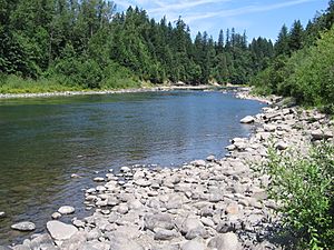
The Clackamas River is a beautiful river in northwestern Oregon, United States. It flows for about 83-mile (134 km) before joining the Willamette River. The river's basin, or the land it drains, covers about 940 square miles (2,435 km2).
The Clackamas River starts high up in the Cascade Range mountains. It flows through thick forests and rugged areas at first. As it gets closer to the Willamette River, it passes through farms and towns. This river is important for many reasons. It helps make electricity and provides drinking water for people in the Portland area.
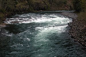
Many types of fish live in the Clackamas River. These include Coho salmon, Chinook salmon, and steelhead. The river is also a great place for outdoor fun. People enjoy fishing and whitewater rafting here. Because of its natural beauty and importance, over half of the river is part of the National Wild and Scenic Rivers System. Native American tribes, like the Clackamas tribe, have lived along this river for thousands of years.
Contents
River's Journey: Where the Clackamas Flows
The Clackamas River begins its journey on the western side of the Cascade Range. This is near Olallie Butte, between Mount Hood and Mount Jefferson. It starts in Marion County within the Mount Hood National Forest. From its source, the river drops almost 4,900 feet (1,500 m) as it flows towards the Willamette River.
The river generally flows northwest, then west. It passes through a flatter area called Big Bottom. Along its way, many smaller streams, called tributaries, flow into the Clackamas. These include the Collawash River and the Oak Grove Fork Clackamas River.
As the river continues, it flows near Oregon Route 224. It goes under this highway several times. The Clackamas River also passes through important areas like Milo McIver State Park. This park is a popular spot for visitors.
Further downstream, the river enters North Fork Reservoir. It then flows past the Faraday Dam and River Mill Dam. These dams help control the river's flow and generate power.
The Clackamas River eventually reaches Carver. Here, Clear Creek joins it. Finally, the river flows under Interstate 205 and Oregon Route 99E. It then meets the Willamette River between Oregon City and Gladstone.
History of the Clackamas River Area
The land around the Clackamas River has a long and rich history. For thousands of years, it has been home to people and amazing wildlife.
Early Native American Life
Long ago, before the 1800s, tall conifer trees covered most of the Clackamas River area. The streams were full of fish like salmon and steelhead. Native Americans lived here as early as 10,000 years ago. They hunted, fished, and gathered food and materials.
About 2,000 to 3,000 years ago, they built permanent villages along the lower part of the river. This was the home of the Clackamas tribe. They were part of the Chinookan speakers. Their lands stretched from Willamette Falls to where the Clackamas River meets the Columbia River.
When explorers Lewis and Clark visited in 1806, about 1,800 Clackamas people lived in 11 villages. Some large villages were near the river's mouth. During winter, families stayed in their villages. In other seasons, they used trails to visit temporary camps.
Sadly, diseases like smallpox and malaria greatly reduced the Clackamas population. By 1851, only 88 people remained. In 1855, the tribe gave up their lands. Even so, some members continued to visit the area from the Warm Springs Indian Reservation to fish and gather berries until the 1930s.
Clackamas River Watershed: A Vital Ecosystem
The Clackamas River basin is like a giant bowl that collects water. It is made up of 16 smaller areas called subwatersheds. This whole basin covers about 940 square miles (2,400 km2).
Most of the upper part of the basin is in the rugged Mount Hood National Forest. This area is managed by the U.S. Forest Service. The lower part of the watershed has more farms and towns. This land is mostly owned by private citizens. Some areas are managed by timber companies or the Bureau of Land Management. About 72 percent of the watershed is public land.
Drinking Water for Many Communities
The Clackamas River provides drinking water for over 200,000 people! Several cities and water districts get their water from the Clackamas. These include the City of Estacada, Clackamas River Water, and the City of Lake Oswego.
Protecting the River's Health
The Clackamas River Basin Council is a group dedicated to protecting the river. It includes people from many different backgrounds. They work together to care for the river and its natural resources. Their goal is to keep the watershed healthy for future generations.
The Clackamas River watershed is very important for fish. It has the last big group of wild late-winter Coho salmon in the Columbia Basin. It also has one of only two remaining groups of spring chinook salmon in the Willamette basin. Many steelhead, cutthroat trout, and native lamprey also live here.
Wild and Scenic River Status
A large part of the Clackamas River is specially protected. About 47 miles (76 km) of the river, from Big Springs to Big Cliff, is part of the National Wild and Scenic Rivers System (NWSRS). This means it is recognized for its amazing natural features.
- Recreation: The river offers great chances for fun activities like whitewater rafting. It's close to the Portland area, making it easy to visit.
- Fish Habitat: It's a vital home for anadromous fish. These fish, like wild late-winter Coho salmon, spring chinook salmon, and winter steelhead, swim from the ocean to freshwater to lay their eggs.
- Wildlife: The river's forests provide homes for special birds. These include the federally threatened bald eagle and northern spotted owl. There's also potential habitat for the threatened peregrine falcon.
- Old-Growth Forests: Along the river banks, you can find beautiful old-growth Douglas-fir trees. These ancient forests are very important.
- History: The river also has a rich history, important to the region and nation.
Some of the river's smaller branches are also protected. All 13.5 miles (21.7 km) of the Roaring River are designated as Wild and Scenic. A part of the South Fork Clackamas River, about 4.2 miles (6.8 km), also gained Wild and Scenic status in 2009.
Caring for the Clackamas River
Sometimes, rivers can face challenges like pollution. In 2008, a study looked at pesticide pollution in the lower Clackamas River. Pesticides are chemicals used to control pests.
The study found different types of pesticides in the river and its smaller streams. They were found more often during storms. Fewer pesticides were found in the drinking water after it was treated. The study suggested that pesticides could affect river life and drinking water quality. This shows why it's so important to protect our rivers and keep them clean for everyone.
 | Madam C. J. Walker |
 | Janet Emerson Bashen |
 | Annie Turnbo Malone |
 | Maggie L. Walker |


