Olallie Butte facts for kids
Quick facts for kids Olallie Butte |
|
|---|---|

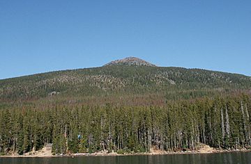
Olallie Butte from the south
|
|
| Highest point | |
| Elevation | 7,219 ft (2,200 m) |
| Geography | |
| Parent range | Cascades |
| Topo map | USGS Olallie Butte |
| Geology | |
| Age of rock | Pleistocene |
| Mountain type | Shield volcano |
| Volcanic arc | Cascade Volcanic Arc |
| Last eruption | More than 25,000 years ago |
| Climbing | |
| Easiest route | Trail |
Olallie Butte is a tall, steep-sided shield volcano in the Cascade Range in northern Oregon, USA. It is the biggest volcano and the highest point in the 50 miles (80 km) between Mount Hood and Mount Jefferson.
Olallie Butte is found just outside the Olallie Scenic Area. It is surrounded by over 200 lakes and ponds. These lakes are filled by rain, melting snow, and water from underground. They are popular places for fishing, boating, and swimming. The butte stands out in the Mount Jefferson area. It is usually covered with snow during winter and spring.
Olallie Butte is a type of volcano that has not been worn down as much as other volcanoes nearby. Its central part, called a volcanic plug, can be seen. Scientists think the butte is between 70,000 and 100,000 years old. There is no sign that it has erupted in the last 25,000 years. Olallie Butte has a steep, cone-like shape. It is made of a rock called basaltic andesite.
A Forest Service fire lookout tower was built on top of the mountain in 1915. It was no longer used after 1967. Another small building, a cupola cabin, was there from 1920 until its roof fell in 1982. The name Olallie comes from a Native American word, klallali, which means berries. Today, the butte is part of the Warm Springs Indian Reservation. The Pacific Crest Trail goes along the western side of the butte. Other trails lead to the top of the mountain. Even though the main trail to the top is not always well kept, hikers can still use it.
Contents
Where is Olallie Butte?
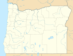
Olallie Butte is located in three counties in Oregon: Jefferson, Marion, and Wasco. The volcano is just outside the Olallie Roadless Area. This area is part of the Mount Hood National Forest. It is west of the main Cascade Range and north of the Mount Jefferson Wilderness.
This region covers about 13 square miles (34 km²) of high land with small volcanoes. You can reach it by trails from the Clackamas and Breitenbush River areas. Logging roads also enter the northern part of the Olallie area.
Lakes and Water Around the Butte
Olallie Butte has many small, unnamed lakes, especially at its southern base. Most of these lakes are shallow. Scientists believe that glaciers moving over Olallie Butte created dozens of these lakes.
Olallie Lake is the largest of over 200 bodies of water near Olallie Butte. It is part of the 14,238-acre (57.62 km²) Olallie Lake Scenic Area. The lake gets its water from rain, melting snow, and underground water. It does not have clear rivers flowing into or out of it. Many other lakes in the Olallie Butte area are similar. A small dam was built on the Mill Creek outlet to keep Olallie Lake's water level steady. Shitike Creek starts between Olallie Butte and Mount Jefferson. It flows east to the Warm Springs community and then joins the Deschutes River.
Olallie Butte is a noticeable landmark in the Mount Jefferson region. It is usually covered with snow in winter and spring. The U.S. National Geodetic Survey says Olallie Butte is 7,219 feet (2,200 m) high.
How to Get There
The cinder cone is about 10 miles (16 km) north of Mount Jefferson. It is also about 2 miles (3.2 km) northeast of Olallie Lake. You can reach Olallie Butte from Oregon Route 22. Follow Breitenbush Road to the Olallie Lake Guard Station. Then, continue on the main road along the power lines. A trail to the top of the mountain is about 3 miles (4.8 km) long. It starts past a clearing on the main road. Trucks cannot go past this point.
Plants and Animals
The forests near Olallie Butte have trees typical of the Cascade Range. These include lodgepole pine, mountain hemlock, noble fir, Pacific silver fir, western hemlock, and western white pine. Less common trees are Alaska yellow cedar, alpine fir, Douglas fir, western red cedar, and whitebark pine. There are also several open grassy areas called meadows, like Olallie Meadow. This meadow covers about 100 acres (0.40 km²) north of the Butte.
Sometimes, mountain pine beetles attack the lodgepole pine trees in the area. Forest managers try to keep the trees for people to enjoy, so cutting them down for wood is not common.
Life in Olallie Lake
Osprey birds build nests on the shores of Olallie Lake. The Oregon Department of Fish and Wildlife adds rainbow trout and brook trout to the lake every year. You can also find kokanee salmon in the water. The lake is surrounded by huckleberry plants. These berries are usually ready to pick by the end of August.
Olallie Lake is shallow, with an average depth of 16.5 feet (5.0 m). Its edges have rocky bottoms. The water has very few minerals, probably because most of its water comes from snow and rain. The water is very clear, and you can see the bottom even at its deepest point, which is 43 feet (13 m). This means the lake has very low amounts of algae and other tiny plants. The lake stays cool all year, even in summer.
How Olallie Butte Formed
Olallie Butte is part of the High Cascades, a section of the larger Cascade Range. It is one of several shield volcanoes in Oregon that are not very high. This means they have not been worn away by weather as much as other volcanoes. Olallie Butte is part of an area called the Jefferson Reach. This area has many shield volcanoes, cinder cones, and lava domes.
Olallie Butte is a shield volcano, but it has a more cone-like shape than typical flat shield volcanoes. It is made of a type of rock called basaltic andesite. This rock is rich in minerals like magnesium and iron. Nearby volcanoes include Sisi Butte and the Pinhead shield volcanoes. There are also cinder cones like Fort Butte and Potato Butte. Some rocks from these cones are black and orange. This suggests that hot lava touched wet ground or snow, cooling quickly.
Glaciers and Rocks
Unlike Sisi Butte, Olallie Butte has not been worn down much by nature. Glaciers carved out parts of Olallie's northeastern side. They also uncovered the central volcanic plug. This shows that the volcano is at least 25,000 years old. The lower slopes of Olallie are steep because a thick ice sheet, about 500 to 1,000 feet (150 to 300 m) deep, once covered the area.
Rocks from glaciers, called glacial till, cover about half of the land around Olallie. These rocks are mostly basaltic andesite and andesite. Most of the volcanic rocks in the area are from the Cenozoic Era. They are mostly lava flows and broken rock pieces called breccias. These rocks often have visible crystals of minerals like hypersthene, clinopyroxene, or olivine.
Scientists have not found any large amounts of valuable minerals in the Olallie area. However, the region has hot springs. This means it could be a future source of geothermal energy, which uses heat from the Earth.
When Did Olallie Butte Erupt?
Olallie Butte is at least 25,000 years old. It likely formed from eruptions before the last ice age. Scientists think it is between 70,000 and 100,000 years old.
Olallie Butte has not erupted in the last 10,000 years. The biggest danger in the area would be from lava flows. There are also some lava domes nearby. If these domes collapse, they could cause small but dangerous flows of hot gas and ash called pyroclastic flows. They could also create mudflows, known as lahars.
Human History
The United States Board on Geographic Names officially named Olallie Butte in 1915. The Olallie Lake Resort was built in 1932. It is in a remote part of the Olallie Scenic Area. The resort is open from June to October. It has a small store, rowboats, and 10 cabins with wood-burning stoves. There is no phone, internet, electricity, gas, or ATM service there.
The name Olallie comes from the Chinook Jargon word klallali, which means berries. This word was historically used for huckleberry bushes. Olallie Butte is part of the Warm Springs Indian Reservation. The Olallie Lake Scenic Area is next to the reservation.
The United States Forest Service built a fire lookout tower on the summit of Olallie Butte in 1915. It is 30 feet (9.1 m) tall. Another small building, a cupola cabin, was also on the summit from 1920. It was left empty in 1967, and its roof fell in 1982. You can still see parts of the old building on top of the butte.
In the 1930s, the Civilian Conservation Corps built a two-story cabin. This cabin is now called the Olallie Lake Guard Station Cabin. It was built for forest rangers. The cabin is a good example of buildings from the Great Depression era. In 1991, it was added to the National Register of Historic Places. Today, visitors can rent the cabin. It has a kitchen, living room, bedroom, and a loft for up to eight guests. It uses propane for lighting and the refrigerator. It also has a stove, oven, water tank, and an outdoor toilet. The cabin is about 5,000 feet (1,500 m) high. You can reach it by car, but snow might block the way.
Fun Things to Do
Olallie Lake is a popular spot for fishing. You are not allowed to swim or use boats on Olallie Lake itself. However, swimming is allowed at nearby Head Lake. You can rent boats and life jackets from the Olallie Lake Resort.
Part of the Pacific Crest Trail goes through this area. Pacific Crest Trail #2000 (Clackamas) runs for 24.9 miles (40.1 km) into the Olallie Lake Scenic Area. A 3.2-mile (5.1 km) part of this trail goes along the western side of Olallie Butte towards Olallie Lake.
There are many other trails for hikers of all skill levels. One trail goes to the top of Olallie Butte. From there, you can see amazing views of north-central Oregon. There is also a 2.7-mile (4.3 km) trail around Olallie Lake, called Olallie Lake Trail 731.
You can climb the western side of the butte using a trail that is not always well kept. This trail climbs 2,580 feet (790 m) in elevation from Forest Road 4220, north of Olallie Lake. This trail goes through tribal land. It is about 3 miles (4.8 km) long to the summit. The round trip is about 8 miles (13 km). There is no shade or water on this hike.
Camping
The United States Forest Service manages seven campgrounds in the Olallie area. Three of these are on Olallie Lake. These campgrounds have outdoor toilets but no running water. You do not need to make a reservation to camp at these sites.
Across all the campgrounds in the Olallie Scenic Area, there are 97 campsites. Each site has a campfire ring and a picnic table. Campgrounds have quiet hours from 10 pm to 6 am. You can also reserve the Olallie Lake Guard Station Cabin, run by the United States Forest Service. It can be rented from June through September for a fee.
 | Janet Taylor Pickett |
 | Synthia Saint James |
 | Howardena Pindell |
 | Faith Ringgold |


