
Sandy, Oregon facts for kids
Quick facts for kids
Sandy, Oregon
|
|
|---|---|
.jpg)
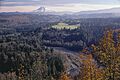
View of Mount Hood and the Sandy River from Jonsrud Viewpoint in Sandy
|
|
| Motto(s):
"Where Innovation Meets Elevation"
|
|

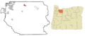
Location of Sandy in Clackamas County, Oregon
|
|
| Country | United States |
| State | Oregon |
| County | Clackamas |
| Incorporated | August 11, 1911 |
| Area | |
| • Total | 3.64 sq mi (9.44 km2) |
| • Land | 3.63 sq mi (9.40 km2) |
| • Water | 0.01 sq mi (0.04 km2) |
| Elevation | 1,101 ft (336 m) |
| Population
(2020)
|
|
| • Total | 12,612 |
| • Density | 3,474.38/sq mi (1,341.56/km2) |
| Time zone | UTC-8 (Pacific) |
| • Summer (DST) | UTC-7 (Pacific) |
| ZIP code |
97055
|
| Area code(s) | 503 and 971 |
| FIPS code | 41-65250 |
| GNIS feature ID | 2411809 |
| Website | www.ci.sandy.or.us |
Sandy is a city in Clackamas County, Oregon, United States. It was settled around 1853 and got its name from the nearby Sandy River. The city is located in the foothills of the Cascade Mountain Range. It is known as the western entrance to the Mount Hood Corridor, about 27 miles (43 km) east of Portland.
Sandy was first settled by people traveling on Barlow Road. This road was one of the last parts of the famous Oregon Trail. The first name for the settlement was Revenue, after the early settlers Francis and Lydia Revenue. Later, the city was named Sandy, just like the Sandy River. Explorers Meriwether Lewis and William Clark named the river in 1805. Before that, it was called the Barings River.
In the late 1800s and early 1900s, Sandy's economy mostly relied on logging and sawmill work. This was because there were many trees in the area. The city grew as German immigrants arrived in the late 1800s. Sandy officially became a city in 1911. In the second half of the 1900s, more people moved to Sandy as the Portland metropolitan area grew.
In 2020, the city had a total population of 12,612 people. Sandy is home to Sandy High School, which opened in 1914. This school serves students from Sandy and nearby towns like Boring and the Villages of Mount Hood.
Contents
History of Sandy, Oregon
Early Settlement: 18th–19th Centuries

Sandy began when a pioneer named Sam Barlow traveled through the area in 1845. He created Barlow Road, which was the most used final part of the Oregon Trail. The first people to settle here were Francis and Lydia Revenue, around 1853. They were drawn to the area because of its rich natural resources. These included fish, deer, elk, berries, and roots. They built a home and a trading post. Around 1873, the Revenue family built the city's first hotel.
The settlement was first called Revenue, after the family. But in the late 1800s, it took the name Sandy from the nearby Sandy River. The river itself was named by Meriwether Lewis and William Clark during their 1805 expedition. They called it the "Quicksand River" because of all the sand on its banks. Before that, Lieutenant W.R. Broughton had named the river the Barings River. He named it after Sir Francis Baring, 1st Baronet, an English merchant banker, in 1792.
A second hotel was built in Sandy in 1890 by Baron Otto Von Scholley. He was an Austrian immigrant who also became the city's second postmaster. In 1894, Sandy's first church, St. Michael's Roman Catholic Church, was finished. Benedictine monks started it, and the first service was on December 18. The original building later burned down, but it was rebuilt in a new location.
Growth and Change: 20th Century

In 1902, a Lutheran church was built in Sandy. On August 11, 1911, Sandy officially became an incorporated city. On November 14, 1913, citizens voted to approve its city rules. Friedrich Meinig, a German immigrant and businessman, came to Sandy in 1876. His son, Paul Meinig, served as the city's second mayor from 1912 to 1918. A big part of Sandy's economy in the late 1800s and early 1900s was logging and sawmill work. This was because of the many forests around the city.
In October 1913, a large fire destroyed many buildings and businesses in Sandy. These included a restaurant, a stable, and a saloon on Main Street. A new concrete building was later built to replace the restaurant and saloon. This was the first concrete building in the city. The Clackamas County Bank opened in Sandy in 1916. As of 2018, it is the oldest community bank in Oregon.
In 1919, a year before the 19th Amendment gave women the right to vote, Sandy elected two women to its government. Blanche Shelley became mayor, and Edna Esson joined the city council. Both women were also important business leaders in Sandy. In 1923, the city finished building the Pioneer Building. This brick building cost $30,000 and became Sandy Union High School. Before this, a small two-story schoolhouse served all grades. A separate high school was started in 1917.
Sandy Today: 21st Century
In the 21st century, Sandy's population has grown a lot. This is partly because the Portland metropolitan area has also grown. A 2018 study found that Sandy is the second-fastest-growing city in Oregon. It is expected to have a population of 18,980 by the year 2034.
Geography and Climate
Where is Sandy Located?
According to the United States Census Bureau, Sandy covers a total area of about 3.14 square miles (8.13 square kilometers). Almost all of this area is land. The city's elevation is about 967 feet (295 meters) above sea level.
What is Sandy's Climate Like?
Sandy has warm, dry summers. The average monthly temperatures do not go above 71.6°F (22°C). According to the Köppen Climate Classification system, Sandy has a warm-summer Mediterranean climate. This type of climate is often shown as "Csb" on climate maps.
| Climate data for Sandy, OR | |||||||||||||
|---|---|---|---|---|---|---|---|---|---|---|---|---|---|
| Month | Jan | Feb | Mar | Apr | May | Jun | Jul | Aug | Sep | Oct | Nov | Dec | Year |
| Mean daily maximum °F (°C) | 44 (7) |
48 (9) |
53 (12) |
58 (14) |
64 (18) |
70 (21) |
77 (25) |
78 (26) |
72 (22) |
61 (16) |
49 (9) |
43 (6) |
60 (16) |
| Mean daily minimum °F (°C) | 28 (−2) |
32 (0) |
33 (1) |
41 (5) |
45 (7) |
50 (10) |
53 (12) |
54 (12) |
50 (10) |
45 (7) |
40 (4) |
35 (2) |
43 (6) |
| Average precipitation inches (mm) | 10.24 (260) |
8.04 (204) |
8.08 (205) |
6.93 (176) |
5.71 (145) |
4.12 (105) |
1.31 (33) |
1.41 (36) |
3.58 (91) |
6.53 (166) |
11.19 (284) |
11.15 (283) |
78.29 (1,989) |
People of Sandy: Demographics
| Historical population | |||
|---|---|---|---|
| Census | Pop. | %± | |
| 1900 | 96 | — | |
| 1910 | 250 | 160.4% | |
| 1920 | 242 | −3.2% | |
| 1930 | 284 | 17.4% | |
| 1940 | 473 | 66.5% | |
| 1950 | 1,003 | 112.1% | |
| 1960 | 1,147 | 14.4% | |
| 1970 | 1,544 | 34.6% | |
| 1980 | 2,905 | 88.1% | |
| 1990 | 4,152 | 42.9% | |
| 2000 | 5,385 | 29.7% | |
| 2010 | 9,570 | 77.7% | |
| 2020 | 12,612 | 31.8% | |
| Source: U.S. Decennial Census |
|||
What the 2010 Census Showed
.jpg)
In 2010, the census counted 9,570 people living in Sandy. There were 3,567 households and 2,486 families. The city had about 3,048 people per square mile (1,177 per square kilometer). There were 3,768 homes, with about 1,200 homes per square mile (463 per square kilometer).
Most of the people in Sandy were White (90.0%). Other groups included African American (0.4%), Native American (1.3%), and Asian (1.2%). About 9.2% of the population was Hispanic or Latino.
Of the households, 40.6% had children under 18 living with them. About 51.7% were married couples. The average household had 2.68 people, and the average family had 3.17 people.
The average age in Sandy was 32.8 years. About 29% of residents were under 18. About 10.2% were 65 years or older. There were slightly more females (51.1%) than males (48.9%).
Education in Sandy
Sandy has three schools within its city limits: Sandy Grade School, Cedar Ridge Middle School, and Sandy High School. These schools are managed by the Oregon Trail School District.
Culture and Community Life
Parks and Events
Meinig Memorial Park is the biggest park in Sandy. It has a stage, a log gazebo, and an amphitheater. There are also many picnic tables and trails through the trees. All the park structures are made from wood. Many events happen at Meinig Memorial Park, such as the yearly Easter egg hunt, Movies at the Park, and shows from the Library Summer Reading Program.
The Sandy Mountain Festival is also held at Meinig Memorial Park. This is a two-day event with over 120 artists and food stalls. It takes place on July 11–12 and is run by the Sandy Mountain Festival Association, a group of volunteers.
Local Favorites
Joe's Donuts is a famous donut shop in Sandy. It opened in 1974 and has become a popular spot for tourists. Joe's Donuts is located where two major highways cross through Sandy. It is known for its red and white checkered outside, which was recently updated by the city's Facade Improvement program.

Getting Around Sandy: Transportation
.jpg)
U.S. Route 26 runs through the center of Sandy. It forms Pioneer and Proctor Boulevards in downtown Sandy. Sandy is also the northern end of Oregon Route 211.
Public Transportation
From the 1940s to the 1960s, a private company called Portland Stages, Inc provided bus service connecting Sandy with Gresham and Portland. In 1970, a new public agency called TriMet took over this service. TriMet continued to serve Sandy until 2000.
Since 2000, Sandy has run its own public transit system called the Sandy Area Metro. This system connects with TriMet's bus and MAX light rail system at the Gresham Transit Center. Since 2004, the Mount Hood Express (originally Mountain Express) has also offered bus service in Sandy. It connects Sandy with communities and resorts in the Mount Hood Corridor.
Airports in Sandy
There are two airports in Sandy: the Sandy River Airport and Country Squire Airpark.
Media and News
The Sandy Post is the weekly newspaper for the community. It is the official newspaper for the city's legal announcements.
Utilities and Services
As of 2015, the City Government offers fast fiber-optic internet to all its residents. It costs $60 per month for gigabit internet and $40 per month for 300 mbps internet.
Notable People from Sandy
- Nan Britton (1896–1991), a secretary and mistress of President Warren G. Harding.
- George Bruns (1914–1983), a film composer.
- Alma Francis (1890–1968), a Broadway and silent film actress and singer.
- Bill Johnson (1960–2016), an Olympic skier.
- Brenda Strong (1960–), a film and television actress.
- Mark Thorson (1983–), a football player.
Images for kids
-
View of Mount Hood and the Sandy River from Jonsrud Viewpoint in Sandy
-
Location of Sandy in Clackamas County, Oregon
See also
 In Spanish: Sandy (Oregón) para niños
