
Barlow Road facts for kids
Quick facts for kids Barlow Road |
|
|---|---|

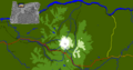
Route of the Barlow Road (red); some consider the yellow route from The Dalles as part of the road
|
|
| Location | Oregon, USA |
| Nearest city | The Dalles Government Camp Oregon City |
| Established | 1845 |
|
Barlow Road
|
|
| NRHP reference No. | 92000334 |
| Added to NRHP | April 13, 1992 |
The Barlow Road is a famous old road in Oregon, USA. It was built in 1846 by two pioneers, Sam Barlow and Philip Foster. This road was the very last part of the long Oregon Trail that pioneers traveled.
Before the Barlow Road, pioneers had a tough time reaching the Willamette Valley. They often floated down the dangerous Columbia River on rafts. It was also possible to drive animals over Lolo Pass, but wagons couldn't use that path. The Barlow Road changed everything. It allowed covered wagons to cross the Cascade Range mountains. Even with the road, this last 100 miles (160 km) was the hardest part of the nearly 2,000-mile (3,200 km) Oregon Trail.
The Barlow Road starts near The Dalles. It goes south to Tygh Valley, then turns west. It follows the White River and crosses Mount Hood at Barlow Pass. From there, it follows Camp Creek and the Sandy River. Finally, it leads to Oregon City. Today, parts of the road are still dirt paths, while other sections are paved over by modern highways.
Contents
How the Barlow Road Was Planned and Built

In September 1845, Sam Barlow arrived at The Dalles. Many families were waiting there for river transport. This river trip was very expensive and took a long time. Barlow wanted to find a better, cheaper way to the Willamette Valley.
Barlow and another man, H. M. Knighton, started exploring. Knighton gave up after about 20 to 25 miles (30–40 km). But Barlow kept going with seven wagons. He planned to return if the mountain route was too hard.
On October 1, 1845, Barlow and three others scouted ahead. They entered the foothills of Mount Hood. They thought they saw the Willamette Valley and learned about a trail from local Native Americans. When they returned, Joel Palmer was waiting with 23 wagons. Palmer had also been exploring the area. Together, they started clearing a path through the forest, mostly by burning trees.

The group reached the top of a ridge, now called Barlow Pass. They were a bit lost there. Barlow, Palmer, and Harrison Porter Locke hiked to scout a path off the mountain. Palmer climbed high on a glacier, taking notes on the rivers and ridges.
They returned to the group and set up a camp called Fort Deposit. Some families stayed there with their wagons. The rest went back to The Dalles. Barlow's group then followed the Sandy River west on foot. They eventually reached Philip Foster's farm near Clackamas.
That autumn, Barlow asked the Provisional Legislature of Oregon for permission to build a road. He said it would cost about $4,000. This was a lot of money back then, like $140,000 today. Permission was given on December 17, 1845. The road was officially named "Mount Hood Road," but everyone called it the "Barlow Road."
God never made a mountain but what He provided a place for man to go over or around it.
The road charged a toll for two years, starting January 1, 1846. It cost five dollars for each wagon. This was about a week's pay for many people. It also cost ten cents for each horse, mule, or cow.
Philip Foster helped pay for the road, and a crew of forty men built it. They had to cut down many trees and build bridges over rivers like the Sandy and White Rivers. The White River bridges are still challenging today.
In its first year, 152 wagons and many animals used the road. Even with repairs, the road was often very rough.
Early Travelers on the Road

For many years, people mostly traveled one way on the road, from east to west. In 1861, a better path was made through Laurel Hill. The road was very popular, even though it was difficult and cost money. In the first year, over a thousand immigrants and about 150 wagons used it. About three-quarters of all pioneers going to the Willamette Valley used the Barlow Road. The others took the Columbia River route.
Barlow and Foster stopped running the road in 1848. Barlow gave the road to the state, but it became very run down. Other people tried to operate the toll road, but it was hard to make money because of the weather and mountain conditions. By 1863, the toll for a wagon was $2.50.
The construction of the Barlow Road contributed more towards the prosperity of the Willamette Valley and the future State of Oregon, than any other achievement prior to the building of the railways in 1870.
In 1849, a military group used the road. They had 250 tons of supplies in over 400 wagons. Many mules died, and they left 45 wagons behind. Their camp became known as Government Camp.
Later Years and Historic Status
Different owners ran the road until 1882. Then, the Mount Hood & Barlow Road Company took over. E. Henry Wemme bought the company in 1912 and made improvements. When Wemme died in 1914, his lawyer, George W. Joseph, became the owner. Joseph and his wife gave the road to the people of Oregon in 1919.
In 1923, the Oregon government named the path from Idaho to the Pacific Ocean the "Old Oregon Trail." They put up signs with prairie schooner images for drivers.
In 1978, the entire Oregon Trail, including the Barlow Road, was named a National Historic Trail by the U.S. Congress. This means it's a special place important to history. In 1992, the Barlow Road was added to the National Register of Historic Places. In 2005, part of it became part of the Mount Hood Scenic Byway.
The Barlow Road Today

Today, U.S. Route 26 follows much of the old Barlow Road route from Sandy to Government Camp. South of Government Camp, US 26 runs near the old road.
Some parts of the Barlow Road are still dirt roads, especially along Barlow Creek. Other sections are deep ruts, up to six feet deep, left by the old wagons. The eastern part of the original road is in Mount Hood National Forest. It follows small Forest Service roads and "Jeep trails." About twenty percent of the original road can still be seen today.
At Laurel Hill, just west of Government Camp, there's a marker and a trail. This spot was very steep, with a 60% slope. Pioneers had to lower their wagons down the hill using ropes wrapped around trees.
Images for kids
-
Route of the Barlow Road (red); some consider the yellow route from The Dalles as part of the road
