
Government Camp, Oregon facts for kids
Quick facts for kids
Government Camp, Oregon
|
|
|---|---|
.jpg)
Center of business district in Government Camp
|
|

Government Camp, Oregon
Location in Oregon

Government Camp, Oregon
Location in the United States
|
|
| Country | United States |
| State | Oregon |
| County | Clackamas |
| Area | |
| • Total | 0.75 sq mi (1.94 km2) |
| • Land | 0.75 sq mi (1.94 km2) |
| • Water | 0 sq mi (0.00 km2) |
| Elevation | 3,891 ft (1,186 m) |
| Population
(2020)
|
|
| • Total | 179 |
| • Density | 239.5/sq mi (92.46/km2) |
| Time zone | UTC-8 (Pacific (PST)) |
| • Summer (DST) | UTC-7 (PDT) |
| ZIP code |
97028
|
| FIPS code | 41-30250 |
| GNIS feature ID | 2584415 |
Government Camp is a small community in Clackamas County, Oregon. It's located right at the base of Mount Hood. This makes it the main "mountain town" or "ski town" for the area.
Government Camp is the perfect starting point for visiting several ski resorts. The most popular ones are Timberline Lodge and Mount Hood Skibowl. The community even has its own smaller ski area called Summit Pass.
You can find Government Camp along U.S. Route 26, which is also known as the Mount Hood Highway. It's close to where this highway meets Oregon Route 35 and the Barlow Pass summit of the Cascade Range. In 2020, about 179 people lived here.
Contents
A Look at the Population
Government Camp is a small community. The number of people living there has changed over time.
| Historical population | |||
|---|---|---|---|
| Census | Pop. | %± | |
| 2020 | 179 | — | |
| U.S. Decennial Census | |||
How Government Camp Got Its Name
The name "Government Camp" comes from a story that happened a long time ago. Settlers were traveling on the Barlow Road. This was a difficult path through the mountains.
In 1849, a group of U.S. Cavalry troops had to leave their wagons and supplies behind. They couldn't take them any further on the tough road. This spot became known as "Government Camp" because of the abandoned government wagons. You can even see a sign about this history at the town's post office.
Weather in Government Camp
Government Camp has a unique climate. Summers are cool and dry. Winters are cold and very wet. There's a lot of snow because of a weather system called the Aleutian Low.
| Climate data for Government Camp, Oregon (1991–2020 normals, extremes 1951–present) | |||||||||||||
|---|---|---|---|---|---|---|---|---|---|---|---|---|---|
| Month | Jan | Feb | Mar | Apr | May | Jun | Jul | Aug | Sep | Oct | Nov | Dec | Year |
| Record high °F (°C) | 70 (21) |
69 (21) |
70 (21) |
80 (27) |
93 (34) |
98 (37) |
99 (37) |
105 (41) |
94 (34) |
83 (28) |
70 (21) |
65 (18) |
105 (41) |
| Mean maximum °F (°C) | 54.0 (12.2) |
52.8 (11.6) |
58.2 (14.6) |
66.1 (18.9) |
74.6 (23.7) |
79.6 (26.4) |
85.7 (29.8) |
87.0 (30.6) |
82.8 (28.2) |
72.2 (22.3) |
59.3 (15.2) |
49.3 (9.6) |
89.0 (31.7) |
| Mean daily maximum °F (°C) | 37.1 (2.8) |
37.8 (3.2) |
41.0 (5.0) |
45.1 (7.3) |
53.7 (12.1) |
59.3 (15.2) |
69.2 (20.7) |
70.3 (21.3) |
64.2 (17.9) |
52.7 (11.5) |
41.5 (5.3) |
35.3 (1.8) |
50.6 (10.3) |
| Daily mean °F (°C) | 31.8 (−0.1) |
32.0 (0.0) |
34.5 (1.4) |
37.8 (3.2) |
44.9 (7.2) |
50.2 (10.1) |
58.4 (14.7) |
59.3 (15.2) |
54.4 (12.4) |
44.9 (7.2) |
35.9 (2.2) |
30.5 (−0.8) |
42.9 (6.1) |
| Mean daily minimum °F (°C) | 26.4 (−3.1) |
26.1 (−3.3) |
28.1 (−2.2) |
30.5 (−0.8) |
36.1 (2.3) |
41.2 (5.1) |
47.5 (8.6) |
48.4 (9.1) |
44.6 (7.0) |
37.2 (2.9) |
30.4 (−0.9) |
25.7 (−3.5) |
35.2 (1.8) |
| Mean minimum °F (°C) | 12.2 (−11.0) |
13.7 (−10.2) |
18.8 (−7.3) |
22.3 (−5.4) |
27.1 (−2.7) |
32.8 (0.4) |
37.8 (3.2) |
38.4 (3.6) |
33.0 (0.6) |
25.3 (−3.7) |
19.0 (−7.2) |
12.5 (−10.8) |
6.6 (−14.1) |
| Record low °F (°C) | −8 (−22) |
−13 (−25) |
1 (−17) |
12 (−11) |
18 (−8) |
23 (−5) |
29 (−2) |
32 (0) |
23 (−5) |
10 (−12) |
−4 (−20) |
−12 (−24) |
−13 (−25) |
| Average precipitation inches (mm) | 12.61 (320) |
9.64 (245) |
9.41 (239) |
7.78 (198) |
5.75 (146) |
4.01 (102) |
0.88 (22) |
1.09 (28) |
3.06 (78) |
8.42 (214) |
12.69 (322) |
14.43 (367) |
89.77 (2,280) |
| Average snowfall inches (cm) | 48.8 (124) |
39.5 (100) |
35.6 (90) |
17.6 (45) |
4.2 (11) |
0.6 (1.5) |
0.0 (0.0) |
0.0 (0.0) |
0.2 (0.51) |
3.8 (9.7) |
30.6 (78) |
51.6 (131) |
232.5 (591) |
| Average extreme snow depth inches (cm) | 55 (140) |
53 (130) |
53 (130) |
32 (81) |
9 (23) |
0 (0) |
0 (0) |
0 (0) |
0 (0) |
3 (7.6) |
21 (53) |
42 (110) |
55 (140) |
| Average precipitation days (≥ 0.01 in) | 20.2 | 17.4 | 19.9 | 18.7 | 14.3 | 10.6 | 3.8 | 4.1 | 7.4 | 13.1 | 18.7 | 21.0 | 169.2 |
| Average snowy days (≥ 0.1 in) | 10.1 | 9.4 | 9.2 | 6.6 | 2.1 | 0.4 | 0.0 | 0.0 | 0.1 | 1.2 | 7.1 | 12.1 | 58.3 |
| Source: NOAA | |||||||||||||
Images for kids
-
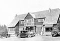
The Battle Axe Inn in Government Camp, 1927
-
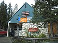
The Post Office in Government Camp with a sign about its name
.jpg)

See also
 In Spanish: Government Camp para niños
