Lolo Pass (Oregon) facts for kids
Quick facts for kids Lolo Pass |
|
|---|---|

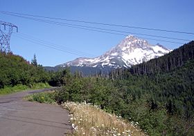
Mount Hood visible behind Lolo Pass
|
|
| Elevation | 3,415 ft (1,041 m) |
| Traversed by | Lolo Pass Road |
| Location | 10 km NW of Mount Hood, Clackamas / Hood River counties, Oregon, U.S. |
| Range | Cascades |
| Coordinates | 45°25′36″N 121°47′45″W / 45.4267847°N 121.7959109°W |
| Topo map | Bull Run Lake |
Lolo Pass is a mountain pass located about 6 miles (10 km) northwest of Mount Hood. It sits on the border between Clackamas and Hood River counties in Oregon. This pass acts like a natural divider. It separates the area where the Sandy River flows (to the southwest) from the area where the Hood River flows (to the northeast).
Exploring Lolo Pass: A Mountain Gateway
Lolo Pass is 3,415 feet (1,041 meters) high. It offers a much lower way to cross the Cascade Range near Mount Hood. For example, Oregon Route 35's Bennett Pass is much higher at 4,650 feet (1,417 meters).
The road leading to Lolo Pass is called Lolo Pass Road (Forest Road 18). From the southwest side, the road is paved all the way to the pass. Once you reach the pass, the road turns into gravel as it goes down the northeast side. Because of heavy snow, Lolo Pass Road closes every winter.
Lolo Pass Through History: An Ancient Trail
The path through Lolo Pass was first created by Native American tribes. They used it as an important trading route. This route connected the Willamette Valley with places at the eastern end of the Columbia River Gorge, like Celilo Falls.
In 1838, a man named Daniel Lee used this trail. He was the nephew of missionary Jason Lee. Daniel Lee drove livestock (like cows) across the pass. He was traveling east to set up a new Methodist station called Wascopam Mission. He was the first person from the Western world known to have used this trail.
Later, the trail became one of the last parts of the famous Oregon Trail. Settlers arriving from The Dalles often guided their livestock over the pass. Meanwhile, their families would float down the river. In 1846, the Barlow Road was built. This new road offered an easier way to go around the south side of Mount Hood.
Lolo Pass and the Pacific Crest Trail
Lolo Pass is also a notable spot along the Pacific Crest Trail. This famous long-distance hiking trail stretches from Mexico to Canada. While Lolo Pass is a milestone, it's not the lowest point on the trail in this area.
About 5 miles (8 km) south of Lolo Pass, the Pacific Crest Trail drops to 2,800 feet (853 meters). It goes even lower to the north, near the Columbia River. There is a small campsite located along the trail. You can find it just south of the forest service road.
 | Kyle Baker |
 | Joseph Yoakum |
 | Laura Wheeler Waring |
 | Henry Ossawa Tanner |


