
Hood River (Oregon) facts for kids
Quick facts for kids Hood River |
|
|---|---|

Along the Mount Hood Railroad near the city of Hood River
|
|

Location of the mouth of the Hood River in Oregon
|
|
| Country | United States |
| State | Oregon |
| County | Hood River |
| Physical characteristics | |
| Main source | Mount Hood Cascade Range 45°36′18″N 121°37′58″W / 45.60500°N 121.63278°W |
| River mouth | Columbia River 79 ft (24 m) 45°42′55″N 121°30′40″W / 45.71528°N 121.51111°W |
| Length | 25 mi (40 km) |
| Basin features | |
| Basin size | 279 sq mi (720 km2) |
| Type: | Scenic, Recreational |
The Hood River is a cool river in northwestern Oregon, USA. It's like a smaller stream that flows into a bigger one, which is called the Columbia River. The Hood River is about 25 miles (40 km) long. It starts high up in the mountains, near Mount Hood in the Cascade Range, and then flows through the pretty Hood River Valley. Finally, it joins the Columbia River in the amazing Columbia River Gorge.
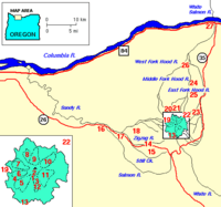
This river begins with three different parts, called forks. All three forks start on the north side of Mount Hood. This area is part of the Mount Hood Wilderness in Hood River County. It's about 50 miles (80 km) east of Portland.
Contents
Where Does the Hood River Start?
The Hood River has three main starting points, or "forks." Each fork begins high up on Mount Hood. These forks then flow down the mountain and eventually meet to form the main river.
West Fork: From a Glacier
The West Fork is about 15 miles (24 km) long. It begins on the northwestern side of Mount Hood, fed by the Ladd Glacier. This fork generally flows towards the east-northeast. It eventually meets up with the East Fork near a town called Dee.
Middle Fork: From Two Glaciers
The Middle Fork is about 10 miles (16 km) long. It starts from several smaller streams on the northern slopes of Mount Hood. These streams are fed by the Coe Glacier and the Eliot Glacier. This fork flows north through the upper part of the Hood River Valley.
East Fork: From the Ski Area
The East Fork is also about 15 miles (24 km) long. It starts on the eastern side of Mount Hood, within the Mount Hood National Forest. It gets its water from the Newton-Clark Glacier, near the Mt. Hood Meadows Ski area. This fork flows north into the Upper Hood River Valley. There, it is joined by the Dog River and then by the Middle Fork.
The Main River Flow
After the forks join together, the main part of the Hood River flows for about 10 miles (16 km). It travels northeast through the beautiful Hood River Valley. The river then empties into the Columbia River at the city of Hood River. This city is a very popular spot for fun water sports like windsurfing and kiteboarding in the Columbia Gorge.
A River with a Story: Its Name and History

The Hood River has an interesting history, especially about its name! When the famous explorers Lewis and Clark mapped the area, they called it the Labeasche River. This was named after one of their team members, Francis Labiche.
How the Name Changed
Later, in the mid-1800s, some travelers were very hungry and had to eat dog meat to survive. Because of this, the river became known as the Dog River. However, people living there didn't like that name very much. A local resident, Mrs. Nathaniel Coe, helped change the name to Hood River, after the nearby Mount Hood. The name Hood River started appearing on maps as early as 1856. The older "Dog River" name is now used for a smaller stream that flows into the East Fork of the Hood River.
Bringing the River Back to Life
For many years, there was a dam called Powerdale Dam on the Lower Hood River. It was built in the early 1920s and helped create electricity. However, this dam was completely removed in the summer of 2010. The old building where the power was made is still there as a reminder.
After the dam was removed, the company that owned it gave over 400 acres of land near the river to Hood River County and Columbia Land Trust. This land is now protected to help the river's natural environment. Other efforts have also helped the Hood River. For example, another dam on Odell Creek was removed in 2016. Farmers in the area are also working to improve their irrigation systems to protect fish.
Thanks to the hard work of groups like the Oregon Department of Fish and Wildlife (ODFW) and the Warm Springs Tribe, the Hood River is becoming a much healthier place for salmon and steelhead fish. This is great news for the river's ecosystem!
Maps
-
Hood River and surroundings
-
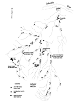
Hood River watershed


