Rockwood, Gresham, Oregon facts for kids
Quick facts for kids
Rockwood
|
|
|---|---|
|
Neighborhood
|
|

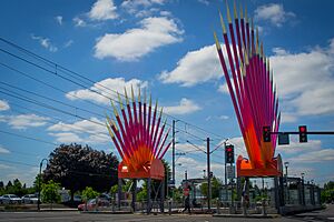
Rockwood MAX Station
|
|
| Country | United States |
| State | Oregon |
| City | Gresham |
| Established | March 14, 1882 |
| Area | |
| • Total | 3.58 sq mi (9.3 km2) |
| Population
(2020 est.)
|
|
| • Total | 15,397 |
| • Density | 4,301/sq mi (1,660.6/km2) |
| ZIP Code |
97230, 97233
|
Rockwood is a lively neighborhood located in the northwest part of Gresham, Oregon. It's known for being one of the busiest and most diverse areas in Gresham. Many different people from all over the world call Rockwood home.
Contents
The Story of Rockwood
Rockwood has an interesting history, starting way back in the late 1800s.
How Rockwood Got Its Name
Imagine a time when roads were marked by stones! In the late 1800s, stone markers were placed every mile east of the courthouse in Portland. This created a road called Baseline Road. Today, this road is known as Stark Street.
Rockwood began to grow at the ten-mile mark on Baseline Road. This spot was where Baseline Road crossed another path called Rockwood Road. Today, Rockwood Road is known as 181st and 182nd Street. The area had many rocks and trees, which inspired its name: Rockwood!
Early Days and Growth
In the early 1900s, Rockwood started to become a small community. A school was built, and a grange hall opened. A grange hall is a meeting place for farmers and their families. A church and a grocery store also opened, along with other small businesses.
On March 14, 1882, the first post office in Rockwood was officially opened. It was started by a man named Cyrus C. Lewis.
Rockwood in the 20th Century
During the 1920s and 1930s, Rockwood was mostly a quiet farming community. People grew a lot of berries there. It also had small areas with shops. During a time called Prohibition, when alcohol was illegal, Rockwood had many secret bars called speakeasies.
After World War II, Rockwood grew very quickly. Many new shopping centers opened up. In the 1950s, builders bought land to create more apartments. By the 1960s, Rockwood had several large mobile home parks. Its growth continued through the 1970s.
In 1986, the MAX Light Rail system from Portland was extended to Gresham, passing through Rockwood. A year later, in 1987, the City of Gresham officially included Rockwood as part of the city. This process is called annexation.
Who Lives in Rockwood?
Rockwood is a very diverse neighborhood, meaning people from many different backgrounds live there.
Population and Income
Rockwood is located in ZIP codes 97233 and 97230. About 10,000 to 15,000 people live in the main neighborhood area. However, the wider Rockwood area has a population of around 40,000 people!
Some families in Rockwood earn less money than others. About 40% of residents earn less than double the federal poverty level. The federal poverty level is a number set by the government to show how much money a family needs to meet basic needs. Also, about 70% of children in Rockwood qualify for free or reduced-price school lunches.
A Community of Many Cultures
Rockwood is known for its amazing diversity. People living here speak over 85 different languages at home! This makes Rockwood a truly unique place where many cultures come together.
Many people who visit the Rockwood Community Health Center are people of color. Also, about 27.5% of the people living in Rockwood were born in other countries. Of these, almost half have become citizens.
Community Services
Rockwood has several important services that help its residents.
Urban Renewal and Transportation
Since 2003, a large area of Rockwood, about 1,200-acre (490 ha), has been part of a Gresham-Rockwood Urban Renewal Area. This means there are special plans and projects to improve and develop the area.
Getting around Rockwood is easy thanks to the MAX Blue Line. The neighborhood has its own light rail station called Rockwood / East 188th Avenue.
Library and Courthouse
Rockwood has been home to a branch of the Multnomah County Library since 1963. Libraries are great places to read, learn, and connect with your community.
In 2010, the county's Board of Commissioners decided to build a courthouse in Rockwood. The Board of Commissioners is a group of elected officials who make decisions for the county. This courthouse was planned to provide court services closer to the residents of Gresham.

