
South Eastern Freeway facts for kids
Quick facts for kids South Eastern FreewaySouth Australia |
|
|---|---|
| General information | |
| Type | Freeway |
| Length | 73.1 km (45 mi) |
| Opened | 1967–2000 |
| Route number(s) | |
| Former route number |
|
| Major junctions | |
| West end | Glen Osmond, Adelaide |
|
|
| East end | Long Flat, South Australia |
| Location(s) | |
| Region | Eastern Adelaide, Adelaide Hills, Murray and Mallee |
| Major suburbs / towns | Crafers, Stirling, Bridgewater, Hahndorf, Mount Barker, Callington, Monarto, Murray Bridge |
| Highway system | |
| Highways in Australia National Highway • Freeways in Australia Highways in South Australia |
|
The South Eastern Freeway is a major road in South Australia. It's about 73 kilometers (45 miles) long. This freeway is a key part of the National Highway system. It connects the state capital, Adelaide, with Melbourne in Victoria. You'll see it signed as route M1.
The freeway helps traffic travel over the Adelaide Hills between Adelaide and the River Murray. Near Murray Bridge, it links up with the Dukes Highway using the Swanport Bridge. This is the main road route to Victoria.
Many people in South Australia just call it "the freeway." This is because it was the first freeway built in the state. It's also still the longest and the only one with "Freeway" in its name. Other similar roads are called "Expressway" or "Highway." The South Eastern Freeway also has special twin tunnels, called the Heysen Tunnels, which are about 500 meters long. These were the first of their kind on the National Highway.
Contents
Where the Freeway Goes
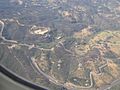
The South Eastern Freeway starts in Glen Osmond. This is where it meets Glen Osmond Road, Cross Road, and Portrush Road. From there, it heads southeast. It has six lanes, with traffic going in both directions on separate roads.
As the freeway crosses the Adelaide Hills, it goes through the Heysen Tunnels. Because many large trucks use this road, it has special safety features. These include arrester beds (ramps for trucks to stop safely if their brakes fail) and strong concrete barriers in the middle. There are also streetlights between Glen Osmond and Crafers.
The freeway becomes four lanes just before it goes around Crafers. It continues southeast, passing towns like Stirling, Hahndorf, and Mount Barker. After that, it narrows to two lanes on a single road. It crosses the Murray River on the Swanport Bridge. The freeway ends just east of the bridge in Long Flat, near Murray Bridge.
How the Freeway Was Built
Early Roads and Planning
Before the freeway was built in the 1960s, cars and trucks used a two-lane highway. This old road was built in the early 1900s. As Adelaide grew, this road became very busy and wasn't safe enough. So, in 1962, people started planning a new freeway. They decided to start the freeway from Crafers because upgrading the old Mount Barker Road would have been very expensive.
Building the Freeway Stages
Construction of the freeway began in 1965, starting from Crafers. The first lanes for eastbound traffic opened in 1967. The first section for westbound traffic opened in 1969. The freeway was opened bit by bit as different parts were finished. The last section, which went around the town of Murray Bridge and connected to the new Swanport Bridge, opened in 1979. This new route offered a better way to cross the River Murray than the older bridge in Murray Bridge.
The new Adelaide–Crafers section was a big improvement. The old Mount Barker Road had many steep turns because it followed the shape of the Adelaide Hills. One very tight turn was known as the Devil's Elbow. It was famous for causing many car and truck accidents.
Modern Upgrades and Tunnels
On May 16, 1995, the Prime Minister at the time, Paul Keating, announced that a new section between Adelaide and Crafers would be built. The Heysen Tunnels were part of this project. They were named after Hans Heysen, a famous South Australian artist. The tunnels were finished in 1998, and the entire construction was completed in early 2000. In March 2000, Prime Minister John Howard officially opened the new road. This was the biggest road project in South Australia at that time. It cost A$151 million, all paid for by the Australian Federal Government.

Around 1999, another exit was added at Monarto. This was to help people get to a growing business area and the Monarto Zoo. In 2014, plans for another exit at Bald Hills Road were announced. This new exit, about 4 kilometers southeast of the Mount Barker interchange, was built to serve new homes in southern Mount Barker and Nairne. Construction started in May 2015 and finished on August 15, 2016. This project cost $27 million.
The freeway now goes around many towns that were once on the old Princes Highway. These towns include:
Road Safety on the Freeway
After the Adelaide–Crafers section opened, there were some accidents involving large trucks. The old Mount Barker Road was known for being dangerous, but the new freeway had its own challenges. It had a long, continuous downhill slope with traffic lights at the bottom. Heavy trucks with weak brakes found it hard to slow down. This problem got worse if their brakes failed. It took some time for truck drivers to get used to the freeway's features. More warning signs were added before the downhill section. Now, you might see large trucks driving as slow as 20–30 kilometers per hour (12–19 mph) when going downhill.
In 2005, electronic road signs were put up every 200 meters. These signs can change the speed limit from the Transport SA headquarters in Adelaide. This has made the road safer for everyone, including emergency workers.
In 2010 and 2011, after more incidents where trucks had trouble braking downhill, new laws were put in place. Any vehicle with five or more axles must now stay in the left lane. They also cannot go faster than 60 kilometers per hour (37 mph) from the Crafers interchange to the old tollhouse. More safety cameras were installed to help make sure trucks follow this new limit.
Extra signs have been added for the two arrester beds on the downhill section. These signs encourage drivers who are losing control to use these ramps. This helps them stop safely and avoid accidents.
In August 2014, another truck going downhill crashed into cars at the Glen Osmond Road intersection. This led to more focus on safety. The government and road authorities continue to work on making the freeway as safe as possible for all drivers.
Connecting Roads
The Adelaide end of the South Eastern Freeway goes downhill to traffic lights. Here, it meets Glen Osmond Road, which continues northwest as route A1 into the Adelaide city centre. Portrush Road goes north to bypass the city and heads towards Port Adelaide. Cross Road goes west towards Adelaide's southern suburbs.
The southeastern end of the freeway, near Murray Bridge, leads onto the Swanport Bridge. This is a 1-kilometer (0.6-mile) long bridge over the River Murray. After the bridge, it joins the Princes Highway. This is a highway with separate roads for each direction that goes to Tailem Bend. At this point, Highway 1 becomes a two-lane, two-way road. It passes through many coastal towns in South Australia and Victoria. The National Highway continues to Melbourne as Dukes Highway (A8) from Tailem Bend to the Victorian border and then as Western Highway.
Gallery
-
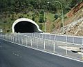
Eastern portal of the Heysen tunnels on the revamped freeway.
-
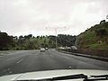
Driving towards Murray Bridge on former Adelaide–Crafers Highway.
-
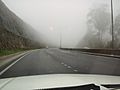
Former Adelaide–Crafers Highway on a foggy day.
-
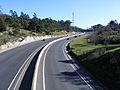
Former Adelaide–Crafers Highway at Crafers.
-
Eagle on the Hill is directly above the tunnel entrance, with the old road winding round from Devil's Elbow.


