
Mount Barker, South Australia facts for kids
Quick facts for kids Mount BarkerSouth Australia |
|||||||||||||||
|---|---|---|---|---|---|---|---|---|---|---|---|---|---|---|---|

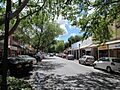
Gawler St, Mt Barker
|
|||||||||||||||

Mount Barker
Location in South Australia
|
|||||||||||||||
| Established | 1839 | ||||||||||||||
| Postcode(s) | 5251 | ||||||||||||||
| Elevation | 360 m (1,181 ft) | ||||||||||||||
| Location | 33 km (21 mi) from Adelaide | ||||||||||||||
| LGA(s) | Mount Barker | ||||||||||||||
| State electorate(s) | Kavel | ||||||||||||||
| Federal Division(s) | Mayo | ||||||||||||||
|
|||||||||||||||
|
|||||||||||||||
Mount Barker is a city in South Australia. It is about 33 kilometres (21 miles) from the centre of Adelaide. In 2021, over 21,500 people lived here. It is the main town in the Adelaide Hills area. Mount Barker is also one of the fastest-growing places in South Australia.
The city sits at the bottom of a mountain also called Mount Barker summit. It is also 50 kilometres from the Murray River. Mount Barker used to be mostly a farming area. While some farms remain, new houses are being built in many places.
Contents
Exploring Mount Barker's Past
Who First Saw Mount Barker?
Captain Charles Sturt first saw the mountain in 1830. He thought it was Mount Lofty, which had been found earlier. This was the first time a European saw Mount Barker. Captain Collet Barker later corrected Sturt's mistake in 1831. Sturt then named the mountain after Captain Barker. This was done after Captain Barker sadly died later that year. King William IV officially recognized the mountain's name in 1834. This was two years before South Australia became a colony in 1836.
Early Climbers of the Mountain
On November 27, 1837, six Europeans climbed the mountain for the first time. These were John Barton Hack, John Morphett, Samuel Stephens, Charles Stuart, Thomas Davis, and John Wade. A few weeks later, on December 25, 1837, four more people climbed it. They were Robert Cock, William Finlayson, A. Wyatt, and G. Barton. They were exploring the land towards Lake Alexandrina.
The First People of Mount Barker
The Peramangk Aboriginal people originally lived in the Mount Barker area. The Ngarrindjeri people from the east also used the Summit. They held important ceremonies and buried their people there. The Mount Barker Summit is a very important Aboriginal site. It might be one of the most sacred places near Adelaide. In the 1980s, the Ngarrindjeri people tried to stop new towers from being built there. Their attempts were not successful.
How Mount Barker Grew
The town of Mount Barker was mapped out in 1839 by Duncan McFarlane. He hoped the land would be good for growing wheat. Farmers started settling in 1844. That's when John Dunn built the first steam flour mill outside of Adelaide. This mill worked for 50 years and is now a place tourists can visit. Other important buildings were built soon after. A post office opened in 1860, and a police station in 1878.
In 1883, a railway line was built from Adelaide to Strathalbyn. This line is no longer used for regular trains. Now, the SteamRanger Heritage Railway uses part of it for special trips.
Mount Barker has grown into a large town very quickly. Between 1996 and 2006, it had the fourth-biggest growth in South Australia. Many new housing areas have been built, like Martin-Dale and Waterford. The town has also seen an economic boom. Many new shopping centres have opened, including the Adelaide Hills Home-maker Centre. There are also plans for even more new shops.
The Discovery of Clover
Mount Barker is famous for a special discovery about a plant called subterranean clover. A. W. Howard found out how valuable this plant, Trifolium subterraneum, was for feeding farm animals. His property was near Princes Highway and Bald Hills Road. People in Europe had known about subterranean clover for a long time. But they thought it was just a common weed.
Howard proved that clover was a great plant for animal feed. It worked well in certain soil types in cooler climates. This discovery changed farming forever. Many farms that were struggling became successful because of it.
Howard shared his discovery with everyone. He wrote articles about clover and gave away seeds for free. He also gave advice to farmers around the world. By the time he died in 1930, thousands of hectares in South Australia had subterranean clover. It was growing all over Australia. Requests for seeds and information came from almost every country with a similar climate.
Howard's work is remembered in a few ways. There is a plaque by the road. The local council's symbol includes a clover leaf. Also, a vineyard and winery on his old property are named Howard's End.
How Mount Barker is Governed
Mount Barker is managed by the District Council of Mount Barker. There are 11 people who serve on this council.
For state elections, most of Mount Barker is in the Kavel area. A small part in the southeast is in Heysen.
For federal elections, Mount Barker is in the Mayo area. The local Member of Parliament for this area is Rebekha Sharkie.
Mount Barker's Location and Surroundings
Mount Barker is located on the flat lands around the Mount Barker Summit. It is about 2 km west of the mountain. The city is southeast of Mount Lofty and Adelaide. It is north of The Coorong and west of Murray Bridge. Mount Barker is 360 metres above sea level.
The city is just south of the freeway that goes from Adelaide to Murray Bridge and Melbourne. Four main roads spread out from the town like a star. To the east, there is an industrial area and the Laratinga Wetlands. North of the wetlands are new housing areas like Martindale, Waterford, and Dalmeny Park. The Mount Barker Creek flows from Keith Stephenson Park to the wetlands. There is a walking trail next to the creek.
People sometimes confuse Mount Barker in South Australia with Mount Barker in Western Australia. This can happen when calling national phone centres.
Mount Barker's Weather
Mount Barker has a warm-summer mediterranean climate. This means it has warm, dry summers. Springs are mild and damp, and autumns are dry. Winters are cool and wet. The weather is usually cooler and wetter than in Adelaide.
The average highest temperature is 20.0 °C (68.0 °F). The average lowest temperature is 8.8 °C (47.8 °F). Winters are often damp and cloudy. When the sky is clear in winter, night temperatures can drop below 0 °C (32 °F).
Summers are warm, with temperatures often reaching 30 °C (86 °F) in January. Some days can even go over 40 °C (104 °F). Summer nights can still be cool. The average yearly rainfall is 737.2 mm. This is more than Adelaide because of Mount Barker's higher elevation. January is usually the driest month, and July is the wettest.
| Climate data for Mount Barker (1991−2020, extremes 1957−2022, rainfall to 1861); 359 m AMSL; 35.07° S, 138.85° E | |||||||||||||
|---|---|---|---|---|---|---|---|---|---|---|---|---|---|
| Month | Jan | Feb | Mar | Apr | May | Jun | Jul | Aug | Sep | Oct | Nov | Dec | Year |
| Record high °C (°F) | 44.5 (112.1) |
43.0 (109.4) |
40.7 (105.3) |
36.0 (96.8) |
28.9 (84.0) |
24.2 (75.6) |
23.8 (74.8) |
27.2 (81.0) |
31.1 (88.0) |
35.3 (95.5) |
40.6 (105.1) |
42.5 (108.5) |
44.5 (112.1) |
| Mean daily maximum °C (°F) | 28.1 (82.6) |
27.9 (82.2) |
25.2 (77.4) |
21.4 (70.5) |
17.2 (63.0) |
14.3 (57.7) |
13.7 (56.7) |
14.8 (58.6) |
17.4 (63.3) |
20.5 (68.9) |
23.6 (74.5) |
25.8 (78.4) |
20.8 (69.5) |
| Mean daily minimum °C (°F) | 12.9 (55.2) |
12.7 (54.9) |
11.0 (51.8) |
9.0 (48.2) |
7.5 (45.5) |
5.9 (42.6) |
5.3 (41.5) |
5.4 (41.7) |
6.6 (43.9) |
7.9 (46.2) |
9.8 (49.6) |
11.3 (52.3) |
8.8 (47.8) |
| Record low °C (°F) | 2.6 (36.7) |
3.3 (37.9) |
1.7 (35.1) |
−1.1 (30.0) |
−3.7 (25.3) |
−4.4 (24.1) |
−5.6 (21.9) |
−3.6 (25.5) |
−1.8 (28.8) |
−1.2 (29.8) |
−1.1 (30.0) |
1.7 (35.1) |
−5.6 (21.9) |
| Average precipitation mm (inches) | 23.4 (0.92) |
25.8 (1.02) |
27.6 (1.09) |
46.3 (1.82) |
76.1 (3.00) |
101.0 (3.98) |
113.3 (4.46) |
103.3 (4.07) |
86.7 (3.41) |
52.6 (2.07) |
39.7 (1.56) |
40.3 (1.59) |
737.2 (29.02) |
| Average precipitation days (≥ 0.2 mm) | 6.6 | 6.1 | 8.0 | 10.6 | 14.7 | 16.6 | 17.5 | 17.1 | 15.0 | 12.1 | 9.7 | 9.0 | 143.0 |
| Average afternoon relative humidity (%) | 44 | 43 | 47 | 55 | 67 | 72 | 71 | 65 | 61 | 56 | 48 | 47 | 56 |
| Average dew point °C (°F) | 11.9 (53.4) |
11.8 (53.2) |
10.7 (51.3) |
9.6 (49.3) |
9.0 (48.2) |
7.4 (45.3) |
6.6 (43.9) |
6.3 (43.3) |
7.4 (45.3) |
8.2 (46.8) |
9.4 (48.9) |
10.5 (50.9) |
9.1 (48.3) |
| Source 1: Australian Bureau of Meteorology | |||||||||||||
| Source 2: Australian Bureau of Meteorology (extremes to 1957, rainfall to 1861) | |||||||||||||
Who Lives in Mount Barker?

In 2021, 51.8% of people in Mount Barker were female, and 48.2% were male. The average age was 37 years old. About 47.4% of residents were married.
Most people living in Mount Barker were born in Australia. In 2006, about 8,274 residents were born in Australia. Other common birthplaces included England, Germany, Netherlands, New Zealand, and Scotland. Most people (90.1% in 2021) speak only English at home. Some also speak German, Italian, or Dutch.
Mount Barker's Economy
Mount Barker's economy is growing fast. New shopping centres and businesses are opening. The population is also increasing. There are plans to expand existing shopping centres and build new ones. The biggest plan is for a new housing area with 1000 homes in the south of the town.
Tasmanian company Huon Aquaculture has a fish smoking factory in Mount Barker. This factory provides jobs for some people in the town.
In 2021, the average income for people in Mount Barker was $824 per week. This was a little more than the national average.
Fun Things to Do and Places to Visit

Mount Barker is the biggest town in the Adelaide Hills. It has many places to shop and eat. There are seven shopping centres, six supermarkets, and lots of restaurants and cafes. Mount Barker Central is the largest and oldest shopping centre. It has a Coles, a Kmart, and over 50 other shops. This building used to be a tannery, a place where animal hides were made into leather.
Mount Barker Village is a smaller shopping centre with a Foodland supermarket. It was updated in 2018 and now has cafes and a butcher. Mount Barker Plaza has an Aldi supermarket and other new stores like Zambrero. There is also a Woolworths supermarket with smaller shops nearby.
The Adelaide Hills Homemaker Centre replaced old industrial buildings. The District Council of Mount Barker has its offices in a multi-storey building there. In 2023, the Aston Hills shopping centre opened. It has a Drakes supermarket. In 2024, Woolworths Mount Barker South also opened in a new shopping centre.
Ukaria Cultural Centre
The Ukaria Cultural Centre is a special place for chamber music. It was designed by Anton Johnson and built in 2015. Besides its concert hall, it has a Garden Terrace for events. The centre also has a program where artists can stay and work.
Local News and Radio
Mount Barker has its own weekly newspaper called The Courier. It serves many towns in the Hills. It started in 1880 and has been printed every week since then. The same family, the Marstons, has owned it since 1954.
Three radio stations serve Mount Barker: 5MU (94.3 MHz), Power FM (100.3 MHz), and Lofty 88.9 (88.9 MHz).
Sports and Recreation

Mount Barker offers many activities. Keith Stephenson Park has the Linear Trail, a lake, a playground, and a skate park. The Mount Barker lawn bowls club is nearby. The Linear Trail goes to the Laratinga Wetlands and is about 3 km long. The Laratinga Wetlands have walking trails and barbecue areas.
Close to Keith Stephenson Park is the Mount Barker Wallis Cinema. It has seven screens with great sound. The cinema is partly underground. It is right next to the Auchendarroch House restaurant.
Mount Barker has three ovals for sports. The Mount Barker oval is next to The Recreation Centre. The Mount Barker Show and local HFL footy matches are held there. Dunn Park is near Cornerstone College. Summit Sport and Recreation Park is a large sports complex. It has an AFL oval and two soccer pitches. It has hosted several AFL "Gather Round" matches. The schools in the area also have their own ovals. Mount Barker has a public swimming pool that is open from September to May.
There is an 18-hole golf course near Bald Hills Road. Mount Barker is also home to the SteamRanger Heritage Railway. This railway runs special steam train trips to Victor Harbor.
A new indoor aquatic and leisure centre is planned next to the Summit Sports and Recreation Park. It will have large swimming pools and water slides. This will offer more modern facilities for residents.
Mount Barker has a rugby league team called the Adelaide Hills Tigers. They play in the NRL South Australia Metro competition.
Community Services

Mount Barker has many important services. The Mount Barker Police station is open 24 hours a day. The Country Fire Service station was also upgraded. Mount Barker has a library next to the TAFE campus. There is also a State Emergency Service branch.
The post office moved to a new building behind McDonald's in 2017.
Mount Barker has an Ambulance Station and a hospital on Wellington Road. The hospital's emergency department was recently updated. There are plans for a big rebuild to make it a multi-story building. It will have more beds and a special area for mental health care. Mount Barker also has an urgent care clinic called Summit Health Center. It is next to the hospital and helps with injuries that are not life-threatening.
Getting Around Mount Barker
Roads
The main way to get to Adelaide is by the South Eastern Freeway. Many people use this road to travel for work. The freeway has two exits for Mount Barker. One was built in the 1970s, and a new one opened in 2016.
Public Transport
Adelaide Metro provides daily bus services from Mount Barker to Adelaide. These buses go through nearby towns like Hahndorf and Stirling. There are also express buses using the freeway. Buses also connect Mount Barker to other Hills towns like Lobethal and Strathalbyn. There are also two local loop buses. The local council offers a special door-to-door service for older people. Mount Barker also has a service called Keolaride. It provides on-demand bus services within the Mount Barker area.
All Mount Barker buses and the Strathalbyn buses meet at the Mount Barker Park 'n' Ride. This facility opened in July 2008. It has parking for cars, bike storage, and a large sheltered waiting area.
Trains
Mount Barker used to have a regular train service to Adelaide. This service stopped in 1984. In 1989, a group called SteamRanger started running special heritage train tours. These trains go from Adelaide to Victor Harbor.
Because Mount Barker has grown so much, some people have asked for the passenger train service to return. However, a report in 2022 said that trains would not be as reliable or fast as buses and cars.
Learning in Mount Barker
Mount Barker has three primary schools: Mount Barker South Primary School, Mount Barker Primary School, and St Marks Primary School (a Lutheran school). Two other schools, St Francis and Waldorf, have both primary and high school sections on the same campus.
Mount Barker has a public high school called Mount Barker High School. There are also three private high schools:
- Cornerstone College, run by the Lutheran Church.
- St Francis de Sales College, which is Catholic.
- Mount Barker Waldorf School, which uses Waldorf Education.
All these schools teach both boys and girls. About 1,500 to 2,000 students attend these high schools. They come from Mount Barker and many nearby towns like Nairne and Strathalbyn.
Images for kids
-
Gawler St, Mt Barker
-
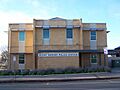
The 24-Hour Mount Barker police station
-

The south entrance to Mount Barker Central, the largest shopping centre in Mount Barker
-
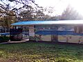
The Mount Barker Mountain Pool, next to the caravan park
-
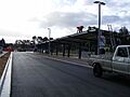
The Park 'n' Ride Facility in Mount Barker being completed
