
Stirling, South Australia facts for kids
Quick facts for kids StirlingSouth Australia |
|||||||||||||||
|---|---|---|---|---|---|---|---|---|---|---|---|---|---|---|---|

Main Street in autumn
|
|||||||||||||||

Stirling
Location in South Australia
|
|||||||||||||||
| Established | 1854 | ||||||||||||||
| Postcode(s) | 5152 | ||||||||||||||
| LGA(s) | Adelaide Hills Council | ||||||||||||||
| State electorate(s) | Heysen | ||||||||||||||
| Federal Division(s) | Mayo | ||||||||||||||
|
|||||||||||||||
Stirling is a beautiful town located in the Adelaide Hills region of South Australia. It's only about 15 kilometers (9 miles) from the heart of Adelaide city centre. The town is looked after by the Adelaide Hills Council.
Stirling is surrounded by other towns like Crafers and Aldgate. You'll also find Heathfield and Bridgewater nearby. Among these towns, Stirling has the biggest shopping area. It offers the most shops and banks. A part of Stirling called Stirling East is home to several schools.
Contents
Stirling's Early History and Growth
Stirling got its name from a person named Edward Stirling. He was an important figure in the area's early days. The town was officially started in 1854.
Stirling grew very quickly because of farming. People started growing many apples and other vegetables for sale. This helped feed the growing city of Adelaide, which was close by.
Many English people also moved to Stirling. They wanted to escape Adelaide's hot summers. Stirling is often about 10 degrees Celsius (18 degrees Fahrenheit) cooler. Because of this, you can still see many old, grand houses in the area. Today, farming is less common as more land is used for homes. Many people who live in Stirling now travel to Adelaide for work every day.
Stirling's Beautiful Trees and Gardens
Stirling is known for its many beautiful trees. Lots of these trees, like maples, elms, oaks, and ash trees, came from Europe and North America.
These trees love Stirling's cool, wet weather. They are a big reason why tourists visit, especially in autumn (April–May). Their leaves turn bright and colourful shades of red, orange, and yellow. This makes Stirling look amazing, just like places in North America or Japan during autumn.
You can also visit other cool places nearby. These include the Mount Lofty Botanic Garden and Cleland National Park.
Stirling's Unique Climate
Stirling has a climate that is warm in summer but still mild. It's known as a warm-summer Mediterranean climate. Because Stirling is close to Mount Lofty, it gets the most rain in all of South Australia.
On average, Stirling receives about 1,107 millimeters (43.6 inches) of rain each year. This is more than twice the amount Adelaide gets! From May to August, it rains a lot, sometimes over 155 millimeters (6 inches) in a month. In June 1916, it rained over 450 millimeters!
Summers in Stirling are about 5 °C (9 °F) cooler than in Adelaide. This is why many people from England and wealthy families chose to live here in the past. Winters are quite cool, especially compared to Adelaide. The average low temperature is about 4 °C (39 °F), and the average high is 11 °C (52 °F).
| Climate data for Stirling (496m ASL; data from 1964–1985) | |||||||||||||
|---|---|---|---|---|---|---|---|---|---|---|---|---|---|
| Month | Jan | Feb | Mar | Apr | May | Jun | Jul | Aug | Sep | Oct | Nov | Dec | Year |
| Record high °C (°F) | 40.7 (105.3) |
39.5 (103.1) |
36.0 (96.8) |
32.1 (89.8) |
24.3 (75.7) |
19.2 (66.6) |
21.7 (71.1) |
27.9 (82.2) |
28.0 (82.4) |
30.6 (87.1) |
37.0 (98.6) |
37.6 (99.7) |
40.7 (105.3) |
| Mean daily maximum °C (°F) | 24.9 (76.8) |
25.4 (77.7) |
21.9 (71.4) |
18.2 (64.8) |
14.6 (58.3) |
11.8 (53.2) |
10.8 (51.4) |
11.9 (53.4) |
13.8 (56.8) |
17.3 (63.1) |
20.1 (68.2) |
22.6 (72.7) |
17.8 (64.0) |
| Daily mean °C (°F) | 18.7 (65.7) |
19.1 (66.4) |
16.6 (61.9) |
13.8 (56.8) |
11.1 (52.0) |
8.7 (47.7) |
8.0 (46.4) |
8.6 (47.5) |
10.0 (50.0) |
12.4 (54.3) |
14.7 (58.5) |
16.8 (62.2) |
13.2 (55.8) |
| Mean daily minimum °C (°F) | 12.4 (54.3) |
12.8 (55.0) |
11.2 (52.2) |
9.4 (48.9) |
7.6 (45.7) |
5.6 (42.1) |
5.1 (41.2) |
5.3 (41.5) |
6.1 (43.0) |
7.5 (45.5) |
9.2 (48.6) |
10.9 (51.6) |
8.6 (47.5) |
| Record low °C (°F) | 4.8 (40.6) |
5.6 (42.1) |
3.8 (38.8) |
2.2 (36.0) |
0.7 (33.3) |
−1.0 (30.2) |
−1.4 (29.5) |
−2.2 (28.0) |
0.0 (32.0) |
0.7 (33.3) |
2.2 (36.0) |
2.8 (37.0) |
−2.2 (28.0) |
| Average rainfall mm (inches) | 36.8 (1.45) |
37.5 (1.48) |
54.3 (2.14) |
96.7 (3.81) |
127.5 (5.02) |
118.0 (4.65) |
175.1 (6.89) |
147.2 (5.80) |
119.7 (4.71) |
91.9 (3.62) |
61.7 (2.43) |
47.0 (1.85) |
1,107.2 (43.59) |
| Average rainy days | 7.5 | 5.5 | 9.7 | 12.4 | 15.8 | 15.9 | 19.4 | 19.4 | 16.2 | 13.9 | 10.4 | 9.0 | 155.1 |
Stirling's Culture and Arts Scene
A well-known place in Stirling is the historic Stirling Theatre. This theatre is home to several performing groups. These include the Hills Musical Company, Stirling Players, and Hills Youth Theatre.
Stirling also loves books! It's sometimes called South Australia's 'Book Village'. This is because it has many places to find books. You can visit Chapter Two Books, Matilda Bookshop, The Hut Book Shed, and the Coventry Memorial Library.
Local Artists in Stirling
Stirling has always had a strong community of artists. One famous artist was Colin Russell Gardiner. He created abstract art and had many exhibitions in the 1970s and 1980s.
Another notable artist was Michael Plant Atchison OAM. He was an Australian cartoonist. He worked for the South Australian Advertiser newspaper for over 40 years.
Stirling's Fire Service
The people of Stirling are kept safe by the Stirling Country Fire Service Volunteers. These volunteers help with fires, car crashes, and dangerous materials.
In 2006, the Adelaide Hills Council wanted to move the fire station. They planned to sell the land where it was located to help pay for a new library. However, the council later decided to sell the land to SAFECOM. This is the group that owns all fire service buildings. A new library was still built and finished in 2008.
Getting Around Stirling: Transport Options
Stirling's Main Street has good public transport. Buses run every 30 minutes during off-peak times. They connect Stirling to the city and nearby Mount Barker. These are routes 864 and 864F.
During busy times, other routes like 863F and T863 also run. Route 863 operates at night and on weekends.
For the east side of Stirling, route 865 goes to and from the city. Route 866 goes to Crafers. Route 822 also connects Stirling to Carey Gully.
If you're heading west towards Heathfield, routes 865 and 894H use Avenue Road and Longwood Road. These services are mostly available during peak times.
Images for kids
-
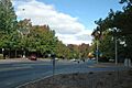
Main street during summer.
-
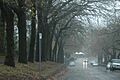
Looking down Druid Avenue through wet autumn weather.


