Kanmantoo, South Australia facts for kids
Quick facts for kids KanmantooSouth Australia |
|||||||||||||||
|---|---|---|---|---|---|---|---|---|---|---|---|---|---|---|---|

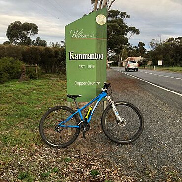
Kanmantoo welcome sign on the Old Highway
|
|||||||||||||||
| Postcode(s) | 5252 | ||||||||||||||
| Location |
|
||||||||||||||
| LGA(s) | District Council of Mount Barker | ||||||||||||||
| State electorate(s) | Kavel | ||||||||||||||
| Federal Division(s) | Mayo | ||||||||||||||
|
|||||||||||||||
Kanmantoo is a small town in South Australia. It is known for its mining history. You can find Kanmantoo southeast of Adelaide, in the eastern Adelaide Hills. The town is located near the Bremer River.
The name "Kanmantoo" comes from an Aboriginal word, "Kunga Tuko." This word means "different speech." In 1839, Scottish settlers were the first Europeans to live in this area. Early residents included Joseph Lean, who arrived in 1840. He was a skilled miner from Cornwall, England. Joseph Lean helped start some of the first mines in Kanmantoo. Some people believe he was the one who found the first copper ore in the Kanmantoo mine.
Town Life and Buildings
Kanmantoo once had many hotels, more than any other town in the Adelaide Hills. However, most of them did not last long. The Kanmantoo Hotel was open the longest, from 1863 to 1929. Today, nothing remains of that hotel.
The town used to be a busy place for mining and business. Now, it is much quieter. In the 1860s, Kanmantoo was at its busiest. Many people worked in the mines, and farming was also important. A blacksmith worked in Kanmantoo from the town's early days. The blacksmith's old cottage is still standing in the town today.
On the edge of Kanmantoo, there is a company called Neutrog. This company makes fertilisers and products to help gardens grow. Neutrog started in 1988 and is based in Kanmantoo. Their factory covers an area of 20 hectares (about 50 acres). Over 50 people work there.
Mining History
The town of Kanmantoo is named after the Kanmantoo mine. This mine is about 2.5 kilometres (1.5 miles) south of the town. In 1840, people discovered copper in the area. The South Australia Company then opened the Kanmantoo mine.
Many people came to Kanmantoo hoping to find wealth. Miners from Cornwall, Germany, England, and Ireland moved to the area. In 1845, geologists said that the copper ore found near the surface looked very valuable. It seemed even better than the ore found at Burra Creek. Because of this, the South Australia Company surveyed a huge area for mining. This area was 4 miles wide and 8 miles long. William Gilles named the mine using a local Aboriginal word.
The original underground mine is now part of a much larger "open cut" mine. An open cut mine is a mine dug from the surface, like a big pit. Today, new searches are happening for more copper and gold deep underground. The mine is currently owned by Hillgrove Resources. It is located in a geological area called the Adelaide Geosyncline.
Getting Around Kanmantoo
Kanmantoo is located on the Old Princes Highway. This road connects Nairne and Callington. Most cars and trucks now use the South Eastern Freeway to bypass the town.
However, cyclists often use the Old Princes Highway. This is because bicycles are not allowed on the freeway between Adelaide and Murray Bridge. The Adelaide-Wolseley railway line also runs close to the mine. But there is no train station in Kanmantoo itself.
 | Delilah Pierce |
 | Gordon Parks |
 | Augusta Savage |
 | Charles Ethan Porter |


