
Gippsland Lakes Discovery Trail facts for kids
Quick facts for kids Gippsland Lakes Discovery Trail |
|
|---|---|

The start of the Gippsland Lakes Discovery Trail in the Colquhoun State Forest
|
|
| Length | 25 km |
| Location | Melbourne, Victoria, Australia |
| Cycling details | |
| Trail difficulty | Medium |
| Hazards | Steep rough hills, isolated locations, uncontrolled road crossings, irregular maintenance |
| Surface | Crushed granite, smooth gravel |
| Hills | Some very steep grades in parts, undulating hills |
| Water | Available in towns |
| Connecting transport | |
| Train(s) | None directly connect to route; nearest is Bairnsdale line |
| Bus | Available in Lakes Entrance |
The Gippsland Lakes Discovery Trail is a fun 25-kilometer path in East Gippsland, Victoria, Australia. It's sometimes called the Mississippi Creek Trail. This trail is a special kind of path called a rail trail, which means it follows the route of an old railway or tramway.
The trail connects the East Gippsland Rail Trail to a popular town called Lakes Entrance. A big part of it goes through the beautiful Colquhoun State Forest. Long ago, this path was a tramway used to carry heavy granite rocks from a quarry all the way to Lakes Entrance.
Work on building the Discovery Trail started in 2000. It was part of a big plan by the Victorian Government to create more rail trails across the state. The trail was fully finished in 2003. Its surface is made of gravel and crushed granite, which are small, hard stones. Some parts of the trail are a bit rough, so they are best for mountain bikes or strong hybrid bikes.
Contents
Exploring the Trail: What You'll See
The Gippsland Lakes Discovery Trail offers different experiences along its path. It starts in a forest and ends near the coast.
From the East Gippsland Rail Trail to the Old Quarry (5 km)
The Discovery Trail begins where it meets the East Gippsland Rail Trail. This spot is in the Colquhoun State Forest, near a track called Seaton Track. The Discovery Trail heads south on a narrow path through the eucalyptus trees. The Rail Trail, on the other hand, goes east and west on a wider, clearer path that used to be a railway line.
At first, the Discovery Trail stays close to Seaton Track. But soon, it goes off on its own, deep into the quiet bush. The path here is made of rough, stony gravel. Much of it is actually crushed granite from the nearby quarry! Some parts of this section are narrow and can be quite steep. It's a good idea to be careful when riding or walking here.
After about 4 kilometers, the trail goes steeply downhill to Quarry Road. You'll follow this road for a short distance. Then, you can take a small detour to see the old granite quarry near Mississippi Creek. This quarry is not used anymore. It was active in the early 1900s. The granite from here was used to build a strong, permanent entrance to the Gippsland Lakes. This new entrance was needed because the old wooden structures were being damaged by tiny sea worms called "marine toledo worms." There's a small area at the quarry where you can stop, rest, and look around.
From the Old Quarry to Log Crossing Picnic Area (7 km)
After visiting the quarry, you'll need to go back to the main trail. This part of the trail follows the exact route of the original Mississippi Creek Tramway. This old tramway was built in the early 1900s and was used until the 1930s. Its job was to carry granite from the quarry to Lakes Entrance. Since the tramway followed Mississippi Creek closely, the Discovery Trail does the same.
The trail continues for about 7 kilometers until it reaches Log Crossing Road. Here, you'll find the Log Crossing Picnic Area. It's a great place to stop for a rest, with toilets and parking available. The Forestech campus, which is part of the East Gippsland Institute of TAFE, is about 2 kilometers away from this spot. You can reach it by a narrow walking and cycling track or by Log Crossing Road.
From Log Crossing Picnic Area to Lakes Entrance (13 km)
From the Log Crossing Picnic Area, the trail continues south-south-east for 2 kilometers. It then meets Scrivener Road, where there's another parking area. At this point, the trail moves away from Mississippi Creek. You'll need to travel about 100 meters east along Scrivener Road. The trail then starts again on the other side of the road, at the bottom of a steep hill.
The path runs next to Scrivener Road for 3 kilometers, slowly turning towards the north-east. Where Scrivener Road meets Lakes-Colquhoun Road, the trail turns again, heading south-south-east. It follows Lakes-Colquhoun Road for about 5 kilometers. This part of the road is mostly flat or gently rolling. Finally, there's a 3-kilometer downhill section that takes you right into Lakes Entrance.
There is a very rough track beside the road for some of this route. However, cyclists are usually advised to ride on the road itself for safety and a smoother ride. Lakes-Colquhoun Road joins the main Princes Highway right at the eastern end of the shopping area in Lakes Entrance.
Images for kids
-
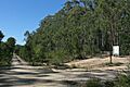
The junction with the East Gippsland Rail Trail in the Colquhoun State Forest
-
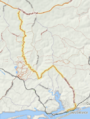
Map of the Gippsland Lakes Discovery Trail.


![]() Geographic data related to Gippsland Lakes Discovery Trail at OpenStreetMap
Geographic data related to Gippsland Lakes Discovery Trail at OpenStreetMap
