Mitchell River silt jetties facts for kids
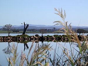
The Mitchell River silt jetties are a super long and thin landform in the Gippsland Lakes area in Victoria, Australia. Imagine a giant, natural pier made of mud and sand! These jetties are a special type of river delta that looks a bit like fingers reaching out into the water.
They have been created over thousands of years by the Mitchell River. When the river flows slowly, it drops off tiny bits of dirt and sand, called sediment. Then, when the river floods, it washes through and shapes these piles of sediment into long, narrow banks. These banks stretch out more than eight kilometres (about 5 miles) into a large lake called Lake King. You can even drive along the south bank from Eagle Point all the way to its very end at Point Dawson!
Contents
What Are Silt Jetties?
Silt jetties are a unique kind of river delta. A delta is a landform that looks like a triangle or a fan, created when a river slows down and drops its sediment as it enters a larger body of water, like a lake or ocean. The Mitchell River silt jetties are special because they are very long and narrow, almost like natural walls or fingers reaching into the lake. This shape is sometimes called a "digitate delta" because it looks like fingers.
How These Jetties Formed
The formation of the Mitchell River silt jetties is a fascinating natural process that took a very long time.
Sediment and Water Flow
It all starts with the Mitchell River carrying tiny pieces of rock, sand, and mud. These tiny pieces are called sediment. As the river flows, it picks up and carries this sediment along. When the river reaches Lake King, its speed slows down a lot. When the water slows, it can no longer hold onto all the sediment it was carrying. So, the sediment starts to sink and settle at the bottom of the lake. Over thousands of years, layers and layers of this sediment built up.
The Role of Floods
The Mitchell River also experiences periods of high water flow, which means floods. During floods, the powerful river water washes through the areas where the sediment has settled. This washing action helps to shape the piles of sediment into the long, narrow banks we see today. It's like the river is sculpting its own landform!
Exploring the Mitchell River Silt Jetties
The Mitchell River silt jetties are not just a cool natural wonder; they are also a great place to visit!
Driving and Views
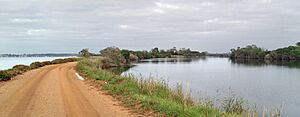
The south bank of the jetties is open for cars. You can drive from a place called Eagle Point all the way to Point Dawson, which is the very eastern tip of the jetties. This drive offers amazing views of the river on one side and Lake King on the other. It's a unique experience to be surrounded by water on both sides as you drive along this narrow strip of land.
Protecting the Jetties
If you look closely at the banks, you might see rocks lining them. These rocks have been carefully placed there to help prevent erosion. Erosion is when wind or water slowly wears away the land. By adding rocks, people are helping to protect this special landform so it can continue to be enjoyed for many more years.
 | Charles R. Drew |
 | Benjamin Banneker |
 | Jane C. Wright |
 | Roger Arliner Young |


