Kowanyama, Queensland facts for kids
Quick facts for kids KowanyamaQueensland |
|||||||||||||||
|---|---|---|---|---|---|---|---|---|---|---|---|---|---|---|---|

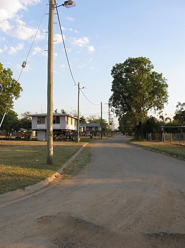
View down Ogimburngk St (from Gilbert St)
|
|||||||||||||||
| Population | 1,079 (2021 census) | ||||||||||||||
| • Density | 0.42734/km2 (1.1068/sq mi) | ||||||||||||||
| Postcode(s) | 4892 | ||||||||||||||
| Area | 2,524.9 km2 (974.9 sq mi) | ||||||||||||||
| Time zone | AEST (UTC+10:00) | ||||||||||||||
| Location |
|
||||||||||||||
| LGA(s) | Aboriginal Shire of Kowanyama | ||||||||||||||
| State electorate(s) | Cook | ||||||||||||||
| Federal Division(s) | Leichhardt | ||||||||||||||
|
|||||||||||||||
Kowanyama is a town and coastal area in the Aboriginal Shire of Kowanyama, Queensland, Australia. It is located on the western side of the Cape York Peninsula.
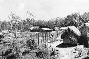
This town was once the site of the Mitchell River Mission, which started in 1916. Before that, there was another mission called Trubanamen Mission, founded in 1905 on Topsy Creek, but it was later left behind.
In 2021, about 1,079 people lived in Kowanyama.
Contents
Exploring Kowanyama's Location
Kowanyama is found on the large Cape York Peninsula in Queensland. Its western side touches the Gulf of Carpentaria. To the north, you'll find the Coleman River.
The Kowanyama area, which is also the size of the Aboriginal Shire of Kowanyama, covers about 2,525 square kilometers. That's a pretty big space!
The Mitchell River flows into Kowanyama from the east. As it gets closer to the Gulf of Carpentaria, the river splits into two parts around Wallaby Island. One part keeps the name Mitchell River, and the other is called Mitchell River (North Arm).
The Aboriginal people who live here belong to groups like the Kokominjena, Kokoberra, and Kunjen. These groups are part of the larger Yir-Yoront people. In their language, Yir-Yoront, the name Kowanyama means "The place of many waters."
The town itself sits on the banks of Magnificent Creek, which flows into the Mitchell River. It's about 20 kilometers (12 miles) inland from the coast of the Gulf of Carpentaria.
You can reach Kowanyama by plane using an all-weather airstrip. During the dry season, you can also use unsealed roads from Pormpuraaw to the north, Normanton to the south, and Cairns to the east.
A Look at Kowanyama's Past
Kunjen is an Aboriginal language spoken in Western Cape York. The areas where Kunjen was traditionally spoken include the Kowanyama Community Council and Cook Shire Council.
Kowanyama State School first opened its doors in January 1904. Since 2014, the school has also offered programs for students in Years 11 and 12.
In 1905, the Trubanamen Mission was set up inland on Topsy Creek. Over time, Aboriginal people from the area were encouraged to move from their traditional lands to this mission. Later, in 1916, the Mitchell River Mission was started at the current site of Kowanyama, and the Trubanamen site was closed. Some people continued to live on their traditional lands, only moving to Kowanyama in the 1940s.
A powerful cyclone hit and destroyed the mission in 1964. The Queensland government then provided money to help rebuild it.
The Kowanyama Post Office began operating around 1967.
By 1967, the Anglican Church found it hard to keep running the mission. So, a government department called the Department of Aboriginal and Islander Affairs took over managing the community.
In July 1987, the Queensland State Government created a special land agreement called a DOGIT (Deed of Grant in Trust). This agreement covered the traditional lands of the Kowanyama people, an area of about 250 square kilometers. Like other DOGIT communities, Kowanyama had a town Council. This Council was elected by the Aboriginal people living there. The Kowanyama Council then became responsible for managing parts of the DOGIT agreement. Seven elected Aboriginal residents serve three-year terms on the Council.
Since the 1990s, many Kowanyama people have been moving back to their ancestral lands. This movement is known as the Homelands Movement.
Other homeland areas, like the Oriners Pastoral Lease and the Sefton Pastoral Lease, were bought by the Kowanyama Council. These areas are outside the main DOGIT boundary.
Kowanyama's People
Kowanyama is one of the biggest communities on the Cape York Peninsula. The Aboriginal people of Kowanyama feel a strong connection to their ancestral lands. They also keep their languages, stories, songs, dances, and histories alive. Some of the language groups in the Kowanyama region include Yir Yoront, Yirrk Thangalkl, Koko Bera, Uw Oykangand, and Olkola.
In 2021, the population of Kowanyama was 1,079 people.
Learning in Kowanyama
Kowanyama State School is a government school for students from early childhood up to Year 10. It is located at 345 Kowanyama Street. In 2018, the school had 190 students and 21 teachers. It also offers a special education program.
If students want to continue their education beyond Year 10, they usually need to use distance education or attend boarding schools, as there are no local options for Years 11 and 12.
Languages Spoken in Kowanyama
The Yir Yiront language is an Aboriginal language from Australia. Its traditional area is in Western Cape York, near the Coleman River and Mitchell River. After Aboriginal people were moved from their traditional lands, the language is now also spoken in Pormpuraaw and Kowanyama.
Kowanyama's Weather
Kowanyama has a tropical savannah climate. This means it has a short, strong wet season from December to March. The dry season lasts much longer, from April to November, with less humidity and cooler nights.
Even though the average daytime temperature is usually above 30 degrees Celsius (86 degrees Fahrenheit) every month, the average night temperatures change a lot. For example, it can be around 15.7 degrees Celsius (60.3 degrees Fahrenheit) in July but 24.5 degrees Celsius (76.1 degrees Fahrenheit) in December.
Kowanyama gets a lot of rain, about 1,274 millimeters (50 inches) each year. Most of this rain falls during the summer. For instance, in February 2014, a huge amount of rain fell – 1,470.6 millimeters (57.9 inches)! The hottest temperature ever recorded was 41.9 degrees Celsius (107.4 degrees Fahrenheit) in December 2019. The coldest was 4.5 degrees Celsius (40.1 degrees Fahrenheit) in August 1990.
| Climate data for Kowanyama (15º28'48"S, 141º45'00"E, 10 m AMSL) (1965-2024 normals and extremes, rainfall 1912-2024) | |||||||||||||
|---|---|---|---|---|---|---|---|---|---|---|---|---|---|
| Month | Jan | Feb | Mar | Apr | May | Jun | Jul | Aug | Sep | Oct | Nov | Dec | Year |
| Record high °C (°F) | 39.5 (103.1) |
38.5 (101.3) |
38.0 (100.4) |
37.4 (99.3) |
36.5 (97.7) |
35.6 (96.1) |
35.6 (96.1) |
37.5 (99.5) |
40.2 (104.4) |
41.0 (105.8) |
41.5 (106.7) |
41.9 (107.4) |
41.9 (107.4) |
| Mean daily maximum °C (°F) | 33.1 (91.6) |
32.5 (90.5) |
33.0 (91.4) |
33.1 (91.6) |
32.2 (90.0) |
30.9 (87.6) |
30.9 (87.6) |
32.4 (90.3) |
34.8 (94.6) |
36.4 (97.5) |
36.4 (97.5) |
35.0 (95.0) |
33.4 (92.1) |
| Mean daily minimum °C (°F) | 24.4 (75.9) |
24.3 (75.7) |
23.9 (75.0) |
22.0 (71.6) |
19.2 (66.6) |
16.5 (61.7) |
15.7 (60.3) |
16.4 (61.5) |
19.1 (66.4) |
22.1 (71.8) |
24.2 (75.6) |
24.5 (76.1) |
21.0 (69.9) |
| Record low °C (°F) | 17.2 (63.0) |
16.5 (61.7) |
13.3 (55.9) |
12.9 (55.2) |
8.5 (47.3) |
5.9 (42.6) |
4.9 (40.8) |
4.5 (40.1) |
9.0 (48.2) |
11.0 (51.8) |
13.7 (56.7) |
14.6 (58.3) |
4.5 (40.1) |
| Average precipitation mm (inches) | 345.9 (13.62) |
363.1 (14.30) |
238.1 (9.37) |
54.7 (2.15) |
11.0 (0.43) |
4.2 (0.17) |
2.4 (0.09) |
2.2 (0.09) |
2.4 (0.09) |
16.3 (0.64) |
56.3 (2.22) |
179.7 (7.07) |
1,274.2 (50.17) |
| Average precipitation days (≥ 1.0 mm) | 15.7 | 15.7 | 12.2 | 3.9 | 0.8 | 0.5 | 0.4 | 0.2 | 0.3 | 1.2 | 3.8 | 9.7 | 64.4 |
| Average afternoon relative humidity (%) | 66 | 69 | 61 | 51 | 44 | 40 | 36 | 33 | 32 | 35 | 43 | 55 | 47 |
| Average dew point °C (°F) | 23.7 (74.7) |
24.1 (75.4) |
22.8 (73.0) |
20.0 (68.0) |
17.0 (62.6) |
14.3 (57.7) |
12.7 (54.9) |
12.4 (54.3) |
13.7 (56.7) |
16.3 (61.3) |
19.2 (66.6) |
21.9 (71.4) |
18.2 (64.7) |
| Source: Bureau of Meteorology (1965-2024 normals and extremes, rainfall to 1912) | |||||||||||||
Getting Around Kowanyama
During the dry season, large trucks called road trains deliver goods to Kowanyama once a week from Cairns. As the wet season gets closer, these deliveries happen more often.
Early storms in October can cause the 400-kilometer (250-mile) dirt road to Chillagoe to flood. By late December, the heavy monsoon rains usually arrive, cutting off the community by road.
The monsoons are seen as the arrival of nhawrr yirrpa, the Rainbow Snake. This snake is believed to bring life-giving water to the land. During the wet season, which can last until May, the only way to reach Kowanyama is by aircraft.
Throughout the wet season, fresh food and other items are flown into the community every week on special charter planes. Regular airline passenger services to Cairns, which is about 600 kilometers (370 miles) away, continue all year through Kowanyama Airport.
 | May Edward Chinn |
 | Rebecca Cole |
 | Alexa Canady |
 | Dorothy Lavinia Brown |


