
Normanton, Queensland facts for kids
Quick facts for kids NormantonQueensland |
|||||||||||||||
|---|---|---|---|---|---|---|---|---|---|---|---|---|---|---|---|

Entry into Normanton
|
|||||||||||||||

Normanton
Location in Queensland
|
|||||||||||||||
| Population | 1,391 (2021 census) | ||||||||||||||
| • Density | 0.19423/km2 (0.5031/sq mi) | ||||||||||||||
| Established | 1867 | ||||||||||||||
| Postcode(s) | 4890 | ||||||||||||||
| Area | 7,161.7 km2 (2,765.1 sq mi) | ||||||||||||||
| Time zone | AEST (UTC+10:00) | ||||||||||||||
| Location |
|
||||||||||||||
| LGA(s) | Shire of Carpentaria | ||||||||||||||
| State electorate(s) | Traeger | ||||||||||||||
| Federal Division(s) | Kennedy | ||||||||||||||
|
|||||||||||||||
|
|||||||||||||||
Normanton is a small town in the outback of Queensland, Australia. It's located in the Shire of Carpentaria, close to the coast. In 2021, about 1,391 people lived in the Normanton area.
This town is the main office for the Shire of Carpentaria. Normanton has a tropical savanna climate, which means it's hot all year with a wet season and a dry season. The main way people make a living here is through cattle farming.
Normanton is also the starting point for the special Normanton to Croydon railway line. This railway was built a long time ago, in the 1890s, during the gold rush. Today, a passenger train called the Gulflander travels this line once a week.
You can find two of Australia's big things in Normanton: a huge "Big Barramundi" fish and a giant statue of "Krys, the Savannah King," a famous saltwater crocodile. The town also has many historic places that show its interesting past.
Contents
Discover Normanton's Location
Normanton is found in the Gulf Country part of northwest Queensland. It sits right on the Norman River, just south of the big Gulf of Carpentaria. It's a small town known for its cattle farms and is the main hub for the Carpentaria area.
The main street in Normanton is called Landsborough Street. About 106 kilometers southwest of town, there's a unique spot called Bang Bang Jump Up. It's one of the few hills in a very flat, wide grassland.
Normanton's Past: A Journey Through Time
The land where Normanton stands has been home to the Gkuthaarn and Kukatj people for a very long time. They are the traditional owners of this area.
The town gets its name from the Norman River. This river was named after William Henry Norman. He was a naval officer who explored the Gulf of Carpentaria and helped map the area.
In May 1867, explorers found a good spot for a new town on the Norman River. The town, first called Norman, was officially started on August 8, 1868. It was seen as a better place to live than Burketown, which had problems with sickness and floods. The first land sales happened in October 1868.
The Norman River Post Office opened in June 1868 and was renamed Normanton by 1872. Normanton State School welcomed its first students in September 1882. A high school section was added in 1976.
The Burns Philp store, a general shop and office, opened in 1884. It's the oldest Burns Philp store still standing in Queensland.
Gold Rush and Railway Boom
Normanton really started to grow when gold was found in Croydon in 1885. Many people, including Chinese people, came to the area hoping to find gold. Chinese market gardeners often grew vegetables for the local communities. Some Chinese men married local women, creating many mixed-heritage families.
The town became even more important when the Normanton to Croydon railway line was finished in 1889. This railway made Normanton the main entry point to north-western Queensland, bringing both people and money to the area. By 1891, the town's population reached 1,251.
However, the gold rush in Croydon didn't last forever. Also, a new railway connecting Townsville to Cloncurry was completed in 1908. This made Normanton less important as a central hub. After the gold ran out in the early 1900s, pastoralism (raising cattle) became the main industry.
Life for Aboriginal People
During this time, some Aboriginal groups were moved to cattle stations to work. Others were forced to move to missions on Mornington Island and Doomadgee. Aboriginal camps were set up on the edges of Normanton. The first Aboriginal reserve was created in 1935.
By 1947, Normanton's population had dropped to just 234 people.
Modern Growth and Native Title
In the 1960s, Normanton's population started to grow again. This was because of the growing prawn fishing industry in nearby Karumba, at the mouth of the Norman River.
In 1965, the Carpentaria Shire Council put up a war memorial in the middle of Landsborough Street. It honors those who served in all wars.
Gulf Christian College was started in 1990 by the Normanton Assembly of God Church. The Normanton library opened in 2004.
A special Normanton Anzac Roll of Honour was revealed in 2017. It lists the names of the Anzacs from the Carpentaria Shire who served in World War I.
After many years of trying, the Gkuthaarn and Kukatj people, who are the traditional owners, were granted native title rights in July 2020. This means they have rights to fish, hunt, and perform their ceremonies on their traditional lands. Cattle farmers can still raise cattle, and the Aboriginal people help manage the land, including controlling pests and protecting cultural heritage sites. Many work as Indigenous rangers, helping to look after the land and sea.
Normanton's People
In 2021, the Normanton area had 1,391 people. About 55.6% of these people identified as Aboriginal and/or Torres Strait Islander. In the town itself, there were 1,326 people, with 57.8% identifying as Aboriginal and/or Torres Strait Islander.
Historic Places to Visit
Normanton has several places that are listed as important heritage sites. These show the town's long history:
- The Burke and Wills Camp B/CXIX
- The Normanton Cemetery
- The old Normanton Gaol
- The Burns Philp Building
- The Westpac Bank Building
- The Normanton railway station
- The Normanton to Croydon railway line
Normanton's Weather
Normanton has a tropical savanna climate. This means it has two main seasons:
- Wet Season: From December to March, it's hot, humid, and can be very uncomfortable. Heavy rain often closes roads. Sometimes, there can be huge amounts of rain from tropical cyclones.
- Dry Season: From April to November, it's hot but usually doesn't rain much. The humidity is lower, the days are clear, and the nights are cooler, making it more pleasant.
Temperatures are generally hot all year. In November, just before the wet season, it can reach around 36.8°C (98.2°F). In July, during the dry season, it's about 29°C (84.2°F). During the wet season, even though temperatures might be a bit lower, the high humidity makes it feel very hot and sticky.
| Climate data for Normanton Post Office, Queensland | |||||||||||||
|---|---|---|---|---|---|---|---|---|---|---|---|---|---|
| Month | Jan | Feb | Mar | Apr | May | Jun | Jul | Aug | Sep | Oct | Nov | Dec | Year |
| Record high °C (°F) | 43.1 (109.6) |
41.0 (105.8) |
40.1 (104.2) |
39.5 (103.1) |
37.2 (99.0) |
35.6 (96.1) |
35.6 (96.1) |
38.3 (100.9) |
40.1 (104.2) |
41.8 (107.2) |
43.3 (109.9) |
43.3 (109.9) |
43.3 (109.9) |
| Mean daily maximum °C (°F) | 34.7 (94.5) |
33.9 (93.0) |
34.2 (93.6) |
34.0 (93.2) |
31.7 (89.1) |
29.2 (84.6) |
29.1 (84.4) |
31.1 (88.0) |
33.9 (93.0) |
35.9 (96.6) |
36.8 (98.2) |
36.1 (97.0) |
33.4 (92.1) |
| Mean daily minimum °C (°F) | 25.1 (77.2) |
24.9 (76.8) |
24.4 (75.9) |
22.4 (72.3) |
19.1 (66.4) |
16.1 (61.0) |
15.2 (59.4) |
16.5 (61.7) |
19.5 (67.1) |
22.6 (72.7) |
24.7 (76.5) |
25.3 (77.5) |
21.3 (70.3) |
| Record low °C (°F) | 18.3 (64.9) |
17.3 (63.1) |
16.7 (62.1) |
14.4 (57.9) |
7.2 (45.0) |
6.7 (44.1) |
7.0 (44.6) |
6.6 (43.9) |
11.1 (52.0) |
13.7 (56.7) |
15.5 (59.9) |
18.9 (66.0) |
6.6 (43.9) |
| Average rainfall mm (inches) | 260.2 (10.24) |
249.2 (9.81) |
157.7 (6.21) |
30.9 (1.22) |
7.5 (0.30) |
9.2 (0.36) |
3.2 (0.13) |
1.7 (0.07) |
3.0 (0.12) |
10.5 (0.41) |
45.1 (1.78) |
144.4 (5.69) |
922.6 (36.34) |
| Average rainy days (≥ 0.2 mm) | 13.9 | 13.9 | 9.4 | 2.4 | 0.9 | 0.7 | 0.5 | 0.3 | 0.4 | 1.3 | 4.4 | 9.0 | 57.1 |
| Average relative humidity (%) | 74 | 78 | 70 | 57 | 52 | 52 | 48 | 44 | 45 | 49 | 54 | 65 | 57 |
Normanton's Economy
The main industry in Normanton is raising cattle. There are several large cattle farms, called homesteads, in the area.
Fun Things to Do in Normanton

Tourism has become a big part of Normanton's economy recently. The Gulflander train is a major attraction for visitors.
One of Normanton's most famous sights is a huge statue of an 8.64-meter (28.3 ft) long saltwater crocodile named Krys. This was the largest crocodile ever caught, shot by Krystina Pawlowska in 1957 in the Norman River.
Another famous landmark is "The Big Barramundi," a 6-meter (20 ft) long fish statue built in 1995.
If you like fishing, you can catch Barramundi and threadfin salmon in the Norman River.
Visitors can also explore many historic sites that tell Normanton's story. These include the Normanton cemetery (from 1867), the railway station and its building (from 1891), and the old Burns Philp & Co. store.
The Normanton railway station is now a railway museum. It's also where you can catch the Gulflander train.
The tourist information center is located in the historic Burns Philp Building.
Learning in Normanton


Normanton State School is a government school for students from Prep (kindergarten) to Year 10. It also has a special education program. In 2018, about 132 students attended the school.
Gulf Christian College is a private school that teaches students from Prep to Year 9. In 2018, it had 96 students.
For students who want to complete Years 11 and 12, there are no local schools. Options include learning from home or going to boarding schools. Many students from Gulf Christian College go to Nambour Christian College for their senior years.
TAFE Queensland also has a campus in Normanton, offering technical college courses.
Community Facilities
The Carpentaria Shire Council has its main offices in Normanton. The Normanton Police Station is also located in town.
Normanton Hospital is a public hospital that provides healthcare services. The Normanton Fire Station, along with the SES facility and the Ambulance Station, are all located together.
There are two cemeteries in Normanton: the Normanton Cemetery and the Aboriginal Burial Grounds. The Aboriginal Burial Grounds are not open to the public.
The Normanton Solar Farm helps provide electricity to the town, making the power supply more reliable. The Centrelink office helps people with government payments and services.
Local Amenities

The Normanton branch of the Queensland Country Women's Association has its rooms on Landsborough Street. Bynoe Hall is a public hall used for community events.
Our Lady Help of Christians Catholic Church is located on Dutton Street. The Aboriginal and Islander Christian Fellowship also has a center in Normanton.
There's a boat ramp on the Norman River with a floating walkway and jetty, managed by the Carpentaria Shire Council. The Normanton public library and visitor information services are in the historic Burns Philp Building.
Normanton also has several sports facilities:
- Normanton Bowls Club
- Normanton Golf Club
- Normanton Gun Club
- Normanton Racecourse and Rodeo Ground
- Normanton Sport Centre
Getting Around Normanton

The Gulf Developmental Road, which is part of the Savannah Way tourist route, starts just 6 kilometers south of Normanton.
The Gulflander passenger train runs once a week. It travels 151 kilometers on the old Normanton to Croydon railway line. The Normanton railway station has a large steel frame that provides shade.
Normanton Airport offers flights to places like Cairns, Burketown, Doomadgee, and Mount Isa. There are also several smaller airstrips on cattle properties within the Normanton area.
Images for kids
-
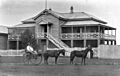
Old Customs House, Normanton, around 1913.
-
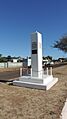
Normanton War Memorial, 2019
-
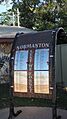
Normanton ANZAC Roll of Honour, 2019
-
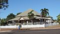
Westpac bank building, Normanton, 2019
-
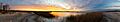
An early October sunset at Mutton Hole Wetlands near Normanton, QLD Australia.


