Croydon, Queensland facts for kids
Quick facts for kids CroydonQueensland |
|||||||||||||||
|---|---|---|---|---|---|---|---|---|---|---|---|---|---|---|---|

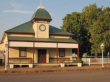
Croydon Shire Hall, 2011
|
|||||||||||||||
| Population | 215 (2021 census) | ||||||||||||||
| Postcode(s) | 4871 | ||||||||||||||
| Elevation | 116 m (381 ft) | ||||||||||||||
| Location |
|
||||||||||||||
| LGA(s) | Shire of Croydon | ||||||||||||||
| State electorate(s) | Traeger | ||||||||||||||
| Federal Division(s) | Kennedy | ||||||||||||||
|
|||||||||||||||
|
|||||||||||||||
Croydon is a small town in the Australian outback, located in Queensland, Australia. It's part of the Shire of Croydon.
This town is famous for being the end stop of the Normanton to Croydon railway line. This line is home to the special Gulflander tourist train, which offers unique trips. In 2021, only about 215 people lived in Croydon.
Contents
Where is Croydon Located?
Croydon is in the Gulf Savannah area of Queensland. A major road, National Highway 1, goes right through Croydon from east to west.
Another road, the Richmond–Croydon Road, is on the eastern side of town. Croydon is about 529 kilometers (329 miles) west of Cairns.
What's the Weather Like?
Croydon has a hot, dry climate. It's known as a semi-arid climate, which means it doesn't get a lot of rain.
There's a short wet season from December to March, and a long dry season from April to November. Temperatures are usually hot all year round.
- The average high temperature is around 33.9°C (93°F).
- The average low temperature is around 20.4°C (69°F).
- The town gets about 732 millimeters (28.8 inches) of rain each year.
Croydon is a very sunny place. It has many clear days and only a few cloudy days each year. The hottest temperature ever recorded was 43.9°C (111°F). The coldest was 2.6°C (36.7°F).
| Climate data for Croydon (18º12'00"S, 142º14'24"E, 116 m AMSL) (1889-2024 normals, extremes 1962-2014) | |||||||||||||
|---|---|---|---|---|---|---|---|---|---|---|---|---|---|
| Month | Jan | Feb | Mar | Apr | May | Jun | Jul | Aug | Sep | Oct | Nov | Dec | Year |
| Record high °C (°F) | 42.8 (109.0) |
41.2 (106.2) |
39.7 (103.5) |
38.0 (100.4) |
36.8 (98.2) |
35.2 (95.4) |
35.4 (95.7) |
37.2 (99.0) |
39.4 (102.9) |
42.2 (108.0) |
43.9 (111.0) |
43.3 (109.9) |
43.9 (111.0) |
| Mean daily maximum °C (°F) | 35.5 (95.9) |
34.5 (94.1) |
34.3 (93.7) |
33.9 (93.0) |
31.6 (88.9) |
29.2 (84.6) |
29.2 (84.6) |
31.2 (88.2) |
34.3 (93.7) |
36.9 (98.4) |
38.0 (100.4) |
37.3 (99.1) |
33.8 (92.9) |
| Mean daily minimum °C (°F) | 24.2 (75.6) |
23.9 (75.0) |
23.3 (73.9) |
21.0 (69.8) |
17.9 (64.2) |
14.7 (58.5) |
14.1 (57.4) |
15.7 (60.3) |
19.2 (66.6) |
22.5 (72.5) |
24.4 (75.9) |
24.6 (76.3) |
20.5 (68.8) |
| Record low °C (°F) | 17.0 (62.6) |
17.2 (63.0) |
13.9 (57.0) |
11.5 (52.7) |
6.0 (42.8) |
3.9 (39.0) |
2.6 (36.7) |
5.2 (41.4) |
7.0 (44.6) |
11.1 (52.0) |
16.7 (62.1) |
15.0 (59.0) |
2.6 (36.7) |
| Average precipitation mm (inches) | 223.4 (8.80) |
180.2 (7.09) |
118.6 (4.67) |
24.4 (0.96) |
8.9 (0.35) |
7.8 (0.31) |
4.2 (0.17) |
2.5 (0.10) |
5.3 (0.21) |
14.2 (0.56) |
45.2 (1.78) |
112.4 (4.43) |
752.7 (29.63) |
| Average precipitation days (≥ 1.0 mm) | 12.0 | 11.3 | 7.3 | 1.7 | 0.9 | 0.7 | 0.5 | 0.3 | 0.5 | 1.4 | 3.9 | 7.3 | 47.8 |
| Average afternoon relative humidity (%) | 50 | 54 | 47 | 36 | 34 | 32 | 29 | 25 | 23 | 25 | 30 | 37 | 35 |
| Average dew point °C (°F) | 21.1 (70.0) |
22.2 (72.0) |
19.8 (67.6) |
15.8 (60.4) |
12.6 (54.7) |
9.6 (49.3) |
7.7 (45.9) |
7.7 (45.9) |
9.0 (48.2) |
12.3 (54.1) |
14.9 (58.8) |
18.3 (64.9) |
14.2 (57.6) |
| Source: Bureau of Meteorology (1889-2024 normals, extremes 1962-2014) | |||||||||||||
A Glimpse into Croydon's Past
Croydon has a rich history, especially linked to gold mining. The town's name comes from a large cattle property owned by Alexander Brown and Margaret Chalmers in the 1880s.
Their sons, Alexander and William, used the name. William Chalmers Brown was born in Croydon, England.
The Gold Rush Era
Gold was found in Croydon in 1885. This discovery quickly led to a huge population boom. By 1887, about 7,000 people lived in the town, all hoping to strike it rich.
The Croydon Post Office opened on March 20, 1886. Gold mining was the main activity for about 40 years. At its busiest, Croydon was the fourth largest town in the colony of Queensland.
Chinese Settlers
Many Chinese settlers moved to Croydon after gold was discovered in 1885. They played a very important role in the town. They grew fresh vegetables and fruit, which was vital for the isolated mining community.
They also worked as cooks and carriers, helping the miners. The Chinese community built a temple and homes on the edge of town. The temple was the main gathering place.
Croydon Today
After the gold rush ended, Croydon's population became much smaller. Today, only a few hundred people live there.
The Gulflander railway, which opened in 1891 for the gold rush, is now a popular tourist attraction. In 2009, a former cyclone caused heavy rain and flooding in Croydon. This led to about $5 million in damage to the town's buildings and roads.
What is Croydon Like Now?
Croydon offers several facilities for its residents and visitors. These include:
- A swimming pool
- A golf course
- Lawn bowls
- A museum
- A tourist information centre
- A caravan park
The Croydon Shire Council runs a public library at 63 Samwell Street. The town gets its water from Lake Belmore.
St Margaret's Church on Alldridge Street is a special place. Both Anglican and Catholic church groups share it for their services.
Education in Croydon
Croydon State School is a government primary school. It teaches students from Early Childhood (Kindergarten) up to Year 6. The school is located at 22–30 Brown Street.
In 2018, the school had 36 students. It had 3 teachers and 7 other staff members helping out.
Places of Historical Importance
Croydon has many places that are listed as important historical sites. These "heritage-listed" sites help us remember the town's past. Some of these include:
- Homeward Bound Battery and Dam
- Content Mine
- Richmond Mine and Battery
- Croydon railway station
- Croydon Cemetery
- Golden Gate Mining and Town Complex
- Station Creek Cemetery
- Normanton to Croydon railway line
- Chinese Temple and Settlement Site
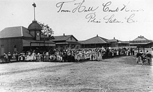
- Court House
- Croydon Shire Hall (which used to be the Town Hall)
- Police Station
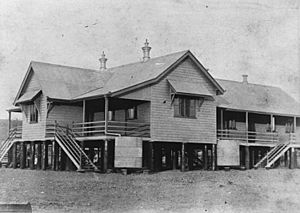
- Croydon Hospital Ward
- Tabletop Cemetery
- Old Croydon Cemetery
 | Shirley Ann Jackson |
 | Garett Morgan |
 | J. Ernest Wilkins Jr. |
 | Elijah McCoy |


