Georgetown, Queensland facts for kids
Quick facts for kids GeorgetownQueensland |
|||||||||||||||
|---|---|---|---|---|---|---|---|---|---|---|---|---|---|---|---|

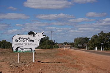
Entry into Georgetown
|
|||||||||||||||
| Population | 254 (2021 census) | ||||||||||||||
| • Density | 0.05807/km2 (0.1504/sq mi) | ||||||||||||||
| Postcode(s) | 4871 | ||||||||||||||
| Elevation | 292 m (958 ft) | ||||||||||||||
| Area | 4,373.9 km2 (1,688.8 sq mi) | ||||||||||||||
| Time zone | AEST (UTC+10:00) | ||||||||||||||
| Location | |||||||||||||||
| LGA(s) | Shire of Etheridge | ||||||||||||||
| County | Gilbert County | ||||||||||||||
| State electorate(s) | Traeger | ||||||||||||||
| Federal Division(s) | Kennedy | ||||||||||||||
|
|||||||||||||||
|
|||||||||||||||
Georgetown is a small rural town and area in Queensland, Australia. It is part of the Shire of Etheridge. In 2021, about 254 people lived in Georgetown.
Contents
History of Georgetown
Georgetown is located on the traditional lands of the Ewamin people.
Gold Rush and Town Naming
In the 1870s, people discovered gold along the Etheridge River. This led to a "gold rush," where many people came to find gold. The town of Georgetown grew up around these gold digging sites.
At first, the town was called Etheridge. But in 1871, its name was changed to Georgetown. This was done to honor Howard St George, an early gold commissioner in the area.
Early Services and Chinese Miners
The Georgetown Post Office opened its doors on January 15, 1872. A few years later, the Georgetown State School welcomed its first students on September 14, 1874.
Like many gold rush towns in Australia, Chinese miners also came to Georgetown. They worked hard to find gold. They even built one or two "Joss Houses," which are places of worship for Chinese people. These buildings were important for their community and traditions.
From Gold to Grazing
By the year 1900, the main way people made money in the Georgetown area changed. Instead of gold mining, raising livestock (like cattle) became the most important activity. This is called grazing.
The Georgetown Public Library opened in 2003, providing books and resources for the community.
Population of Georgetown
The number of people living in Georgetown has changed over the years:
- In 2006, the town had 254 people.
- In 2011, the area had 243 people.
- In 2016, the population grew to 348 people.
- In 2021, the population was 254 people again.
Geography of Georgetown
Georgetown is located in Far North Queensland, Australia, right on the Etheridge River. A main road called the Gulf Developmental Road goes through the town. This road connects Georgetown to Cairns, which is about 380 kilometers (236 miles) to the east. It also connects to Normanton, about 301 kilometers (187 miles) to the west.
Georgetown is the main town for the Shire of Etheridge. This local government area also includes nearby places like Mount Surprise, Forsayth, and Einasleigh.
Climate in Georgetown
Georgetown has a climate that is mostly a tropical savanna climate. This means it has two main seasons: a wet season and a dry season.
Wet Season
The wet season runs from mid-November to March. It is very hot and humid. During this time, most of the rain falls. Sometimes, a lot of rain can fall in just a few days, especially from big storms or even old tropical cyclones. For example, in early 1974, it rained for 55 days in a row!
Dry Season
The dry season lasts from April to mid-November. It is very warm, and it gets even hotter in October and November before the wet season starts. It is also almost completely dry during this time. Even though it's hot, the mornings can be cool, especially in the middle of the dry season. Georgetown is one of the most northern places in Australia to ever record frost, with temperatures dropping below freezing in July 1974.
| Climate data for Georgetown | |||||||||||||
|---|---|---|---|---|---|---|---|---|---|---|---|---|---|
| Month | Jan | Feb | Mar | Apr | May | Jun | Jul | Aug | Sep | Oct | Nov | Dec | Year |
| Record high °C (°F) | 43.5 (110.3) |
41.0 (105.8) |
39.2 (102.6) |
38.3 (100.9) |
36.8 (98.2) |
34.8 (94.6) |
35.4 (95.7) |
37.0 (98.6) |
39.5 (103.1) |
42.6 (108.7) |
43.3 (109.9) |
43.5 (110.3) |
43.5 (110.3) |
| Mean daily maximum °C (°F) | 34.4 (93.9) |
33.5 (92.3) |
33.4 (92.1) |
32.5 (90.5) |
30.4 (86.7) |
28.2 (82.8) |
28.2 (82.8) |
30.0 (86.0) |
33.0 (91.4) |
35.8 (96.4) |
36.6 (97.9) |
36.1 (97.0) |
32.7 (90.9) |
| Mean daily minimum °C (°F) | 22.9 (73.2) |
22.7 (72.9) |
21.5 (70.7) |
19.4 (66.9) |
16.1 (61.0) |
13.1 (55.6) |
12.0 (53.6) |
13.1 (55.6) |
16.2 (61.2) |
19.7 (67.5) |
21.7 (71.1) |
22.8 (73.0) |
18.4 (65.1) |
| Record low °C (°F) | 10.6 (51.1) |
15.1 (59.2) |
11.1 (52.0) |
5.0 (41.0) |
2.2 (36.0) |
−0.6 (30.9) |
−3.0 (26.6) |
−1.1 (30.0) |
2.2 (36.0) |
6.7 (44.1) |
8.9 (48.0) |
11.1 (52.0) |
−3.0 (26.6) |
| Average rainfall mm (inches) | 224.9 (8.85) |
212.9 (8.38) |
123.1 (4.85) |
28.8 (1.13) |
9.3 (0.37) |
10.4 (0.41) |
6.7 (0.26) |
4.3 (0.17) |
6.4 (0.25) |
16.7 (0.66) |
50.7 (2.00) |
127.8 (5.03) |
822 (32.36) |
| Average rainy days (≥ 0.2 mm) | 13.7 | 12.9 | 8.3 | 2.7 | 1.2 | 1.2 | 0.8 | 0.4 | 0.7 | 2.0 | 5.3 | 9.5 | 58.7 |
| Source: Bureau of Meteorology | |||||||||||||
Heritage Sites
Georgetown has some special places that are protected because of their history. These are called heritage-listed sites:
- Aspasia Mine and Battery, located on the Gulf Developmental Road.
- Antbed House, found on South Street.
Education in Georgetown
Georgetown State School is a government school for primary students, from Early Childhood up to Year 6. It is located on High Street. In 2018, the school had 42 students and 4 teachers.
There are no high schools in Georgetown or very close by. For secondary education, students can either learn through distance education (studying from home) or go to a boarding school.
Facilities in Georgetown
Georgetown offers several facilities for its residents and visitors:
- A racecourse for horse racing events.
- A swimming pool, perfect for cooling off.
- A tourist information center and a camping/caravan park for travelers.
- The Etheridge Shire Council runs a public library on Low Street.
- The Georgetown branch of the Queensland Country Women's Association has its meeting rooms on the Gulf Developmental Road.
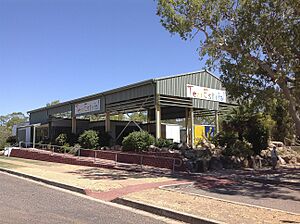
- The Terrestrial Information Centre has the Ted Elliot Mineral Collection. This collection includes over 4,500 different mineral samples from the local area and around the world.
- St Patrick's Catholic Church is located at 26 High Street. It is part of the Gulf Savannah Parish.
 | Emma Amos |
 | Edward Mitchell Bannister |
 | Larry D. Alexander |
 | Ernie Barnes |


