Einasleigh, Queensland facts for kids
Quick facts for kids EinasleighQueensland |
|||||||||||||||
|---|---|---|---|---|---|---|---|---|---|---|---|---|---|---|---|

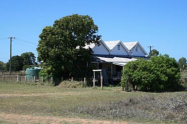
Station master's residence, 2008
|
|||||||||||||||
| Population | 87 (2021 census) | ||||||||||||||
| • Density | 0.02143/km2 (0.0555/sq mi) | ||||||||||||||
| Postcode(s) | 4871 | ||||||||||||||
| Area | 4,060.5 km2 (1,567.8 sq mi) | ||||||||||||||
| Time zone | AEST (UTC+10:00) | ||||||||||||||
| Location |
|
||||||||||||||
| LGA(s) | Shire of Etheridge | ||||||||||||||
| State electorate(s) | Traeger | ||||||||||||||
| Federal Division(s) | Kennedy | ||||||||||||||
|
|||||||||||||||
Einasleigh is a small town and area in Queensland, Australia. It's located in the Shire of Etheridge. In 2021, about 87 people lived in Einasleigh.
Contents
Exploring Einasleigh's Location
Einasleigh is in the northern part of its area. It sits where the Einasleigh River meets the Copperfield River. The Einasleigh River collects water from a huge area, about 24,366 square kilometers.
This river eventually flows into the Gilbert River. Together, they form a wide delta, which is a flat area of land at the river's mouth. This delta is about 100 kilometers wide and has many tidal flats and mangrove swamps. The Einasleigh River drops 730 meters over its 618-kilometer journey.
Ghost Town of Kidston
Did you know there's a ghost town nearby? Kidston is a ghost town located in the southern part of Einasleigh's area. A ghost town is a place where most people have left, and buildings are often empty.
The Railway Line
The Tablelands railway line runs through Einasleigh. It enters from the northeast, near Mount Surprise, and leaves to the west, towards Forsayth. The town of Einasleigh has its own train station, called Einasleigh railway station, located on Railway Street.
Mountains Around Einasleigh
Einasleigh is surrounded by many mountains. Here are some of them, listed from north to south:
- Beril Peak (670 meters high)
- Blackman Peak (650 meters high)
- Fraser Peak (670 meters high)
- The Lighthouse (519 meters high)
- The Canyon (706 meters high)
- Mount Alder (590 meters high)
- Stockmans Hill (570 meters high)
- Mount Juliet (630 meters high)
- Mount Ossa (550 meters high)
- Mount Harry (498 meters high)
- Mount Mambury (670 meters high)
- Mount Blacktop (618 meters high)
- Mount Tabletop (630 meters high)
- Mount Misery (610 meters high)
- Mount Borium (710 meters high)
- The Twins (547 meters high)
- Greys Hill (610 meters high)
- Iib Pinnacles (650 meters high)
- Mount Jordan (615 meters high)
- Ironstone Knobs (656 meters high)
- Paddys Knob (608 meters high)
A Look Back: Einasleigh's History
The original people of the Einasleigh area were the Ewamin indigenous group.
The town's name, Einasleigh, comes from the river. A surveyor and some pastoralists (people who raise livestock) named the river in August 1864.
Police and Post Office
A police station was first set up in Einasleigh in 1900. It closed in 1903, but people soon wondered why a town with two hotels and many visitors didn't have police. So, a station was opened again. The police station building on Baroota Street closed in August 2005, but it is still standing today.
The Einasleigh Post Office opened in May 1909. Before that, there was a smaller "receiving office" from 1900. The Post Office closed in 1993.
Early Schools
Einasleigh Provisional School first opened its doors on October 29, 1901. It closed for a short time in 1905 but reopened in 1906. On January 1, 1909, it became Einasleigh State School. This school eventually closed in 1955. It was located at 5–7 First Street.
Einasleigh's Population Over Time
The number of people living in Einasleigh has changed over the years:
- In 2006, there were 202 people.
- In 2016, the population was 92 people.
- In 2021, the population was 87 people.
Important Historical Places
Einasleigh has several places that are listed for their historical importance. These are called heritage-listed sites:
- Einasleigh Copper Mine and Smelter, on Daintree Road.
- Einasleigh Hotel, on Daintree Street.
- Einasleigh railway station and the Station Master's Residence. These are on the railway line that used to be called the Etheridge railway line.
- Kidston State Battery & Township, located in Kidston.
How Einasleigh Makes Money
A big part of the economy here is the Kidston Solar Project. This is a large solar farm located southwest of the former town of Kidston. This area is one of the best places in Australia for solar power because it gets a lot of sunshine!
In the first part of this project, 540,000 solar panels were installed. These panels can track the sun, meaning they move to follow the sun across the sky to capture the most energy.
Learning in Einasleigh
There are no schools directly in Einasleigh. For primary school, students might go to nearby towns like Forsayth, Georgetown, or Mount Surprise. However, for kids living further away in the south or east of Einasleigh, these schools might be too far for a daily trip.
There are also no high schools close to Einasleigh. For secondary education, students might use distance education (learning from home with materials sent to them) or attend a boarding school (where they live at the school).
 | Delilah Pierce |
 | Gordon Parks |
 | Augusta Savage |
 | Charles Ethan Porter |


