Gilbert River (Queensland) facts for kids
Quick facts for kids Gilbert |
|
|---|---|

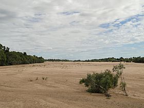
The dry bed of the Gilbert River at the crossing on the Gulf Development Road between Croydon and Georgetown, Queensland.
|
|
|
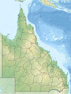
Location of Gilbert River mouth in Queensland
|
|
| Country | Australia |
| State | Queensland |
| Region | Far North Queensland |
| Physical characteristics | |
| Main source | Gregory and Newcastle Ranges, Atherton Tableland below Conical Hill 634 m (2,080 ft) |
| River mouth | Gulf of Carpentaria north of Karumba 0 m (0 ft) 16°32′23″S 141°16′22″E / 16.53972°S 141.27278°E |
| Length | 887 km (551 mi) |
| Basin features | |
| Basin size | 46,810 km2 (18,070 sq mi) |
| Tributaries |
|
| National park | Blackbraes National Park |
The Gilbert River is a major river in Far North Queensland, Australia. It's a really important waterway, especially when you combine it with the Einasleigh River. Together, they form the biggest river system in northern Australia!
Contents
Where is the Gilbert River Located?
The Gilbert River starts near Conical Hill in the Einasleigh Uplands. It gathers water from the eastern side of the Gregory Range and the western side of the Newcastle Range. This area is north of a town called Hughenden.
How the River Flows
The river generally flows towards the northwest. Along its journey, many smaller rivers and creeks join it. These smaller waterways are called tributaries. Some of the main tributaries include the Styx, Percy, Robertson, Langdon, Little, and Einasleigh rivers. These tributaries help drain water from the Blackbraes National Park.
Eventually, the Gilbert River reaches the Gulf of Carpentaria, which is north of Karumba. Interestingly, near Normanton, a part of the river branches off. This branch, called an anabranch, joins the Smithburne River before also flowing into the Gulf.
The River's Catchment Area
The Gilbert River has a huge catchment area of about 22,041 square kilometers (8,510 sq mi). A big part of this area, about 455 square kilometers (176 sq mi), is a wide estuarine delta. This delta is about 100 kilometers (62 mi) wide and is mostly made up of tidal flats and mangrove swamps. The river drops about 635 meters (2,083 ft) over its 887-kilometer (551 mi) course.
Understanding the River's Flow and Floods
The Gilbert River is a seasonal stream, meaning its water level changes a lot throughout the year. The amount of water flowing, called discharge, depends heavily on the strength of the monsoon season.
Seasonal Changes and Water Discharge
When the Gilbert River combines with the Einasleigh River, it has the sixth-highest water discharge of any river in Australia. This is a bit less than the Potomac River in North America. However, during a very strong wet season, the amount of water can be as much as the Fraser River in Canada! But in a mild wet season, like in 1951-52, the discharge can be much, much lower. It's estimated that the water flowing from the Gilbert-Einasleigh system makes up about 2.2 percent of all the water flowing from Australia.
History of Major Floods
The Gilbert River has experienced some big floods. The largest recorded flood happened in January 1974. Other significant floods occurred in February 1991 and in January and February 2009. These floods caused roads to close and properties to be covered in water across the entire catchment area.
The Gilbert River's Environment
The area around the Gilbert River has a tropical climate. This means it's usually warm, and most of the rain falls between December and March. The months from May to September are often very dry, with no rain in most years.
Rainfall and Climate Variability
The amount of rainfall can change a lot each year. This is because the monsoon season can be different, and sometimes there are strong cyclones. For example, in a very wet season like 1973–74 or 1999–2000, the area could get over 1,800 millimeters (71 in) of rain. But in a very dry season, like 1951-52, it might only get about 300 millimeters (12 in) of rain.
Land Use and Natural Features
The Gilbert River is not suitable for producing hydroelectricity (power from water). This is because its flow is too unpredictable. The soils in the area are also not very fertile. They are often made of ironstone gravels or a type of clay called kaolinitic clays.
Because of these factors, the combined Gilbert-Einasleigh River system is one of the few large river systems in the world that flows completely freely. Most of the land in the river basin is natural grassland. It is used for grazing cattle, but only a small number of cattle can be supported due to the poor quality of the grass. The population in this area is very small, with less than one person for every 40 square kilometers (15 sq mi).
The area where the river meets the sea is part of the Gulf Plains Important Bird Area. This means it's a special place for many different kinds of birds.
Traditional Owners of the Land
The traditional owners of the upper part of the Gilbert River catchment area are the Kunjen people. They have a long history and connection to this land.
Why is it Called the Gilbert River?
The river was named in July 1845 by an explorer named Ludwig Leichhardt. He named it to honor a naturalist named John Gilbert. Sadly, John Gilbert was killed just two weeks earlier during a conflict with an Aboriginal group near the Gulf of Carpentaria coast.
 | William Lucy |
 | Charles Hayes |
 | Cleveland Robinson |


