
Hughenden, Queensland facts for kids
Quick facts for kids HughendenQueensland |
|||||||||||||||
|---|---|---|---|---|---|---|---|---|---|---|---|---|---|---|---|

Hughenden's dinosaur statue
|
|||||||||||||||

Hughenden
Location in Queensland
|
|||||||||||||||
| Population | 1,113 (2021 census) | ||||||||||||||
| • Density | 1.1946/km2 (3.094/sq mi) | ||||||||||||||
| Established | 1870 | ||||||||||||||
| Postcode(s) | 4821 | ||||||||||||||
| Elevation | 324.0 m (1,063 ft) | ||||||||||||||
| Area | 931.7 km2 (359.7 sq mi) | ||||||||||||||
| Time zone | AEST (UTC+10:00) | ||||||||||||||
| Location |
|
||||||||||||||
| LGA(s) | Flinders Shire | ||||||||||||||
| County | Douglas | ||||||||||||||
| State electorate(s) | Traeger | ||||||||||||||
| Federal Division(s) | Kennedy | ||||||||||||||
|
|||||||||||||||
|
|||||||||||||||
Hughenden is a country town in the Flinders Shire, Queensland, Australia. It's home to about 1,113 people, according to the 2021 census. Hughenden is famous for its dinosaur statue, which you can see in the town.
Contents
Geography of Hughenden
Hughenden is located on the banks of the Flinders River. This river is very important to the area.
Mountains Around Hughenden
There are several mountains near Hughenden. These include:
- Mount Walker, which is 472 metres (1,549 feet) high.
- Mount Mowbray, standing at 403 metres (1,322 feet).
- Mount Devlin, reaching 459 metres (1,506 feet).
- Mount Castor, also 403 metres (1,322 feet) high.
- Mount Beckford, at 419 metres (1,375 feet).
Location and Farming
Hughenden is on the Flinders Highway. It's about 376 kilometres (234 miles) west of Townsville and 1,400 kilometres (870 miles) north-west of Brisbane, Queensland's capital city.
The land around Hughenden is a big area for raising sheep and cattle. The main food for these animals is a type of grass called Flinders grass. This grass grows quickly after rain, usually between November and March. However, the amount of rain can change a lot each year. This means the area can have both droughts (not enough rain) and floods (too much rain).
Railways and Airport
Hughenden is on the Great Northern railway line. There are several railway stops in the area, though some are no longer used. The main one serving the town is Hughenden railway station.
The town also used to be the end point for the Hughenden-Winton railway line. Hughenden Airport is located just north-east of the town.
History of Hughenden
The land around the upper Flinders River has been home to the Yirandhali people for about 11,000 years. Their language, Jirandali, is an Australian Aboriginal language spoken in this part of North-West Queensland. Another language, Dalleburra, was also spoken here. The Yirandhali people originally called this area Mokana.
Early European Settlement
In October 1861, an expedition led by Frederick Walker camped near where Hughenden is today. Soon after, in 1863, Ernest Henry and Robert Gray started the Hughenden sheep station. The town was named after Hughenden Manor in England, which was the home of a former British Prime Minister, Benjamin Disraeli. Robert Gray and Ernest Henry had family ties to this manor.
The town of Hughenden officially began in 1870. It started as a base for the Native Police, who built simple buildings there. In 1877, William Mark built a pub, and soon after, the town area was surveyed, and land was sold. The Hughenden Post Office opened in 1878.
Schools in Hughenden
Hughenden Provisional School opened on April 22, 1880. It became Hughenden State School in 1884 and later added a secondary school section in 1968. St Francis' Catholic School was opened in 1900 by the Sisters of the Good Samaritan. Another school, Hughenden North Provisional School, opened around 1897 but closed in 1926 due to low student numbers.
World War II Incident
During World War II, American forces stored explosives near Torrens Creek, which is close to Hughenden. They didn't know how dangerous bushfires could be in the area. After putting out a fire, they thought it was safe, but the fire started again without them knowing.
Suddenly, there were about twelve huge explosions one after another! These explosions left craters 20 feet deep. Hot metal flew everywhere and started more fires. In nearby towns, people felt buildings shake and windows break. Some even thought it was an air raid. Thousands of soldiers and local people tried to stop the fire from reaching fuel storage areas, but it was too powerful. When the fire hit the explosives, the blast was so strong it blew Americans out of their trucks. Many buildings and shops burned down, but locals managed to save the post office. A police officer from Torrens Creek was given a bravery medal for his actions.
New Court House
In 1945, plans were made to build a new court house in Hughenden. It was meant to be a two-storey building. However, construction stopped in 1947 because the ground couldn't support such a tall building. The plans had to be changed to a single-storey building. Even with new plans, there were delays due to a lack of building materials and skilled workers. The new court house finally opened in 1955.
Community Contributions
The Hughenden branch of the Queensland Country Women's Association (QCWA) opened their hall in 1960. This group helps women and families in rural areas. In 2003, Mrs Jean Eva Anderson received the Medal of the Order of Australia for her 52 years of service to the Hughenden QCWA branch.
Demographics
In 2016, Hughenden had a population of 1,136 people. By 2021, the population was 1,113 people.
Heritage Sites
Hughenden has some important historical places. One of them is the Grand Hotel at 25 Gray Street, which is a heritage-listed site.
Education
Hughenden has two schools:
- Hughenden State School is a government school for students from Prep (the first year of school) all the way to Year 12. It's located at 12 Moran Street. In 2018, it had 115 students.
- St Francis Catholic School is a Catholic primary school for students from Prep to Year 6. It's located at 8 Flinders Street. In 2018, it had 41 students.
Amenities and Activities
The Flinders Shire Council runs the Flinders Shire Public Library at 39 Grey Street. The Hughenden branch of the Queensland Country Women's Association has its rooms at 42 Stansfield Street.
Hughenden offers many sports and activities, including:
- Pony clubs
- Swimming
- Lawn bowls
- Golf
- Netball
- Tennis
- Campdrafting (a horse sport)
- Rugby league
- Gymnastics
Events
The town hosts the Hughenden Dinosaur Festival. This festival brings in tourists and includes lots of fun entertainment and other events.
Attractions
Hughenden has a cool replica of a Muttaburrasaurus. This was a type of dinosaur whose bones were found near Muttaburra, about 220 kilometres (140 miles) from Hughenden. Some dinosaur teeth and other bones have also been found around Hughenden.
Another interesting spot is the Historic Coolabah Tree. This tree is famous because two expeditions looking for the lost Burke and Wills expedition left marks on it. These search parties were led by Frederick Walker in 1861 and William Landsborough in 1862.
Transport
- Hughenden Airport is the local airport.
Train Services
Hughenden is a stop on the Inlander train service, which travels between Townsville and Mount Isa.
Climate
Hughenden has a hot semi-arid climate. This means it's generally hot and dry. Temperatures can reach around 44°C (111°F) in summer and drop to about -2°C (28°F) in winter. On average, summer days are around 36°C (97°F), and winter days are about 25°C (77°F).
The town gets about 490 millimetres (19 inches) of rain each year. Most of this rain falls from November to March. Between May and September, it's very dry, with almost no rain. However, the amount of rain can change a lot from year to year, leading to very wet or very dry periods. Humidity is usually low, except during the wet season.
| Climate data for Hughenden Post Office | |||||||||||||
|---|---|---|---|---|---|---|---|---|---|---|---|---|---|
| Month | Jan | Feb | Mar | Apr | May | Jun | Jul | Aug | Sep | Oct | Nov | Dec | Year |
| Record high °C (°F) | 43.6 (110.5) |
42.8 (109.0) |
40.1 (104.2) |
37.8 (100.0) |
33.6 (92.5) |
33.5 (92.3) |
34.3 (93.7) |
36.1 (97.0) |
39.3 (102.7) |
40.4 (104.7) |
43.9 (111.0) |
44.0 (111.2) |
44.0 (111.2) |
| Mean daily maximum °C (°F) | 35.8 (96.4) |
34.7 (94.5) |
33.7 (92.7) |
31.4 (88.5) |
27.9 (82.2) |
25.0 (77.0) |
25.0 (77.0) |
27.5 (81.5) |
31.1 (88.0) |
34.5 (94.1) |
36.1 (97.0) |
36.9 (98.4) |
31.6 (88.9) |
| Mean daily minimum °C (°F) | 22.5 (72.5) |
22.1 (71.8) |
20.5 (68.9) |
17.0 (62.6) |
13.2 (55.8) |
9.8 (49.6) |
8.8 (47.8) |
10.4 (50.7) |
14.0 (57.2) |
18.0 (64.4) |
20.5 (68.9) |
22.0 (71.6) |
16.6 (61.9) |
| Record low °C (°F) | 15.4 (59.7) |
15.2 (59.4) |
11.1 (52.0) |
7.2 (45.0) |
2.3 (36.1) |
0.0 (32.0) |
−2.0 (28.4) |
−1.4 (29.5) |
4.8 (40.6) |
7.0 (44.6) |
10.5 (50.9) |
14.6 (58.3) |
−2.0 (28.4) |
| Average rainfall mm (inches) | 114.5 (4.51) |
98.0 (3.86) |
58.2 (2.29) |
26.0 (1.02) |
17.8 (0.70) |
18.6 (0.73) |
11.6 (0.46) |
7.9 (0.31) |
9.0 (0.35) |
22.3 (0.88) |
36.0 (1.42) |
71.1 (2.80) |
491 (19.33) |
| Average rainy days (≥ 0.2 mm) | 8.2 | 7.6 | 4.7 | 2.3 | 1.8 | 1.8 | 1.4 | 0.9 | 1.3 | 2.7 | 4.3 | 6.0 | 43 |
| Source: Bureau of Meteorology | |||||||||||||
Images for kids
-
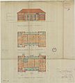
Architectural plans for the two-storey court house drawn up in 1945. This project was abandoned because the foundations couldn't support a two-storey building.
-
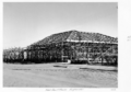
The partly-built one-storey court house in 1952.


