Torrens Creek facts for kids
Quick facts for kids Torrens CreekQueensland |
|||||||||||||||
|---|---|---|---|---|---|---|---|---|---|---|---|---|---|---|---|

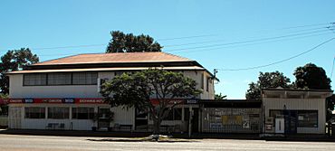
The Exchange Hotel at Torrens Creek
|
|||||||||||||||
| Population | 46 (2021 census) | ||||||||||||||
| • Density | 0.00757/km2 (0.0196/sq mi) | ||||||||||||||
| Postcode(s) | 4816 | ||||||||||||||
| Area | 6,079.9 km2 (2,347.5 sq mi) | ||||||||||||||
| Time zone | AEST (UTC+10:00) | ||||||||||||||
| Location |
|
||||||||||||||
| LGA(s) | Shire of Flinders | ||||||||||||||
| State electorate(s) | Traeger | ||||||||||||||
| Federal Division(s) | Kennedy | ||||||||||||||
|
|||||||||||||||
Torrens Creek is a small town and area in the Shire of Flinders, Queensland, Australia. It is a rural place, meaning it's mostly countryside with farms. In 2021, only 46 people lived in Torrens Creek.
Contents
Where is Torrens Creek?
Torrens Creek is located on the Flinders Highway. This is a major road in Queensland. It is about 1,503 kilometers (934 miles) north-west of Brisbane, which is the capital city of Queensland. It's also 293 kilometers (182 miles) west of the city of Townsville.
Railway Connections
The Great Northern Railway runs through Torrens Creek. This railway line helps connect the town to other places. The Torrens Creek railway station is right in the town. The railway comes from the east (near Pentland) and continues west (towards Prairie).
The Creek Itself
The town is named after Torrens Creek. This creek starts in the Great Dividing Range, which is a large mountain range. The water flows south into the Thomson River system. Eventually, this water reaches Lake Eyre, a large salt lake in South Australia.
Nearby National Parks
Torrens Creek is close to some amazing natural areas:
- White Mountains National Park is in the far north and north-east parts of the area. It's known for its beautiful white sandstone cliffs.
- Moorrinya National Park is on the western edge of the Torrens Creek area. These parks help protect the local wildlife and plants.
Most of the land around Torrens Creek is used for grazing. This means farmers raise animals like cattle on the natural grasslands.
A Look Back in Time
The creek, and later the town, got its name from Sir Robert Richard Torrens. An explorer named William Landsborough discovered the creek in 1862. He was looking for other explorers, Burke and Wills, at the time. Sir Robert Torrens created a new way to register land ownership, which is still used today. Around 1885, the area was sometimes called Boorooman.
Indigenous History and Waterholes
Waterholes along Torrens Creek were very important to the Aboriginal people who lived here. One special place was the Fisheries waterhole (also called Aberfoyle waterhole). Aboriginal people from all around would come here to fish. They used special nets and traps to catch fish like golden perch.
When European settlers arrived, there were disagreements over who owned and could use this important waterhole. In 1865, two cattle station managers were killed at the Fisheries. Sadly, this led to more conflict and loss of life for the Aboriginal people. After this, the waterhole became full of fish because fewer people were fishing there. In 1890, a station manager had to remove many fish to keep the water clear.
The Railway Arrives
The Great Northern Railway reached Torrens Creek in 1885. This was a big deal! It made Torrens Creek a central place for supplies for the whole area. Mailmen would ride long distances from the town to deliver letters to different farms and stations. Some of these mail routes are still used today. There's even a special monument in Torrens Creek for Jack Blunt, a famous mailman who worked there from 1931 to 1954.
School Days
Torrens Creek had a school called Torrens Creek Provisional School, which opened in 1891. It later became Torrens Creek State School in 1909. However, the school closed its doors in 1991. The old school was located at 2 Bedford Street.
World War II Incident
In 1942, during World War II, a big event happened near Torrens Creek. There was a large storage area for ammunition, used by American and Australian soldiers. A fire started by soldiers to clear land got out of control. This caused a series of 12 huge explosions! The explosions left craters about 20 feet (6 meters) deep and almost destroyed the town.
How Many People Live Here?
The number of people living in Torrens Creek has changed over the years:
- In 2006, there were 64 people.
- In 2016, the population grew to 70 people.
- In 2021, the population was 46 people.
What's in Torrens Creek Today?
Even though it's a small town, Torrens Creek has some useful places:
- There's a hotel, which is like a pub, where people can stay or get a meal.
- There's also a garage for car repairs and fuel.
Golf Club
If you like golf, Torrens Creek has an 18-hole golf course! It's called the Torrens Creek Golf Club and is open to both members and visitors.
Things to See
Inside the White Mountains National Park, you can find the Sawpit Gorge Lookout. It's a great spot to see amazing views of the gorge and the surrounding landscape.
Getting Around
Torrens Creek is a stop on the Queensland Rail network. The Inlander train service passes through the town. You can catch the train to Pentland to the east or Hughenden to the west.
Education Options
Torrens Creek itself does not have any schools. Children living in the area might go to primary schools in nearby towns like Prairie or Pentland. For high school, the closest option is Hughenden State School in Hughenden.
However, because the Torrens Creek area is very large, these schools might be too far away for a daily trip. In such cases, students often use distance education (learning from home with online or mailed lessons) or attend a boarding school.
 | May Edward Chinn |
 | Rebecca Cole |
 | Alexa Canady |
 | Dorothy Lavinia Brown |


