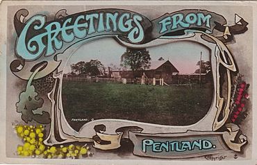
Pentland, Queensland facts for kids
Quick facts for kids PentlandQueensland |
|||||||||||||||
|---|---|---|---|---|---|---|---|---|---|---|---|---|---|---|---|

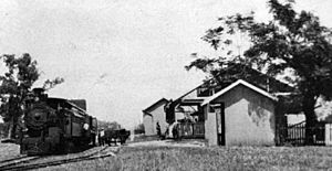
Postcard showing Pentland railway station, 1909
|
|||||||||||||||
| Population | 248 (2021 census) | ||||||||||||||
| • Density | 0.01656/km2 (0.0429/sq mi) | ||||||||||||||
| Postcode(s) | 4816 | ||||||||||||||
| Area | 14,979.5 km2 (5,783.6 sq mi) | ||||||||||||||
| Time zone | AEST (UTC+10:00) | ||||||||||||||
| Location |
|
||||||||||||||
| LGA(s) | Charters Towers Region | ||||||||||||||
| Region | North Queensland | ||||||||||||||
| State electorate(s) | Traeger | ||||||||||||||
| Federal Division(s) | Kennedy | ||||||||||||||
|
|||||||||||||||
Pentland is a small country town in Queensland, Australia. It's part of the Charters Towers Region. In 2021, about 248 people lived there. Pentland is known for its history, especially its connection to gold mining and the meat industry.
Contents
Where is Pentland?
Pentland is located in North Queensland, between the towns of Charters Towers and Hughenden.
The Flinders Highway and the Great Northern railway line both pass right through Pentland. The main road in town is called Main Street.
Natural Features Around Pentland
- A small part of the Campaspe River flows through the eastern side of Pentland.
- The Cape River starts in this area.
- To the north, you'll find a part of the White Mountains National Park.
- In the south, there's a salt lake called Lake Buchanan.
Railway Stations in the Area
The Great Northern railway line has a few stations in the Pentland area:
- Burra railway station
- Warrigal railway station
- Pentland railway station, which serves the town
- Cape River railway station (no longer used)
- Kimburra railway station (no longer used)
There was also a former town called Capeville, located near the Cape River, about 10 kilometers north-northwest of Pentland.
A Look Back: Pentland's History
Pentland has an interesting past, starting with gold and growing with the railway and meatworks.
Gold Rush Days
In July 1867, gold was discovered in the Cape River area. This led to a gold rush, and by 1870, over 20,000 miners were working there! However, the gold didn't last forever, and by 1873, most people had left.
Early Town Development
- A telegraph office opened in 1880, allowing people to send messages.
- The post office, first called Bett's Creek, opened in 1884 and was renamed Pentland in 1885.
- The Great Northern Railway reached Pentland on October 6, 1884, connecting the town to other places.
- Pentland Provisional School opened on May 11, 1885, giving children a place to learn. It became Pentland State School in 1909.
World War II and the Meatworks
During World War II, a large meatworks (a factory that processes meat) opened in Pentland in 1943. It was built to help feed Australian and American soldiers stationed in North Queensland. This meatworks helped the town of Pentland grow and become busy. After the war ended in 1945, the meatworks changed owners several times before finally closing in September 1989.
Community Buildings and Changes
- The Soldiers Memorial Hall opened in 1926 to honor those who served in World War I.
- St Mary's Catholic Church, originally built in 1906 in another town, was moved to Pentland and opened there in 1964.
- In the early 1970s, Pentland had two grocery stores and a town pool. The local hotel was also renovated.
- In 2009, the area of Pentland grew to include nearby places like The Cape, Buchanan, and Torrens Creek.
- In 2018, a new war memorial was opened at the Soldiers Memorial Hall. It remembers all Australian military members who have served and died.
Who Lives in Pentland?
In 2016, Pentland had a population of 306 people. By 2021, the population was 248 people.
Learning in Pentland
Pentland State School is a government primary school for students from Early Childhood (kindergarten) to Year 6. It's located at 18 Mill Street. In 2018, the school had 23 students.
There isn't a high school in Pentland or very close by. This means older students might learn through distance education (learning from home with online lessons) or attend boarding schools in bigger towns.
Places to Visit and Things to Do
Community Hubs
- The Pentland Soldiers Memorial Hall is at 2 Gilmore Street. This is where the annual Anzac Day ceremony is held to remember soldiers.
- There are two churches in Pentland:
- St Aidan's Anglican Church at 21 Mill Street.
- St Mary's Catholic Church at 64 Main Street.
Local Attractions
- The Pentland Hotel, located at 32 Main Street, shares some of Pentland's history. It also offers meals and a place to stay.
- The Burra Range Lookout is a great spot to visit. It's on the Flinders Highway in the west of the Pentland area, within the White Mountains National Park. From here, you can see amazing views of the Great Dividing Range.
Getting Around
Queensland Rail operates a train service called the Inlander. This train travels between Townsville and Mount Isa twice a week. You can book a ticket to stop at Pentland or Torrens Creek.
| Preceding station | Queensland Rail | Following station | ||
|---|---|---|---|---|
| Long distance rail services | ||||
| Charters Towers
towards Townsville
|
The Inlander | Torrens Creek
towards Mount Isa
|
||
 | Georgia Louise Harris Brown |
 | Julian Abele |
 | Norma Merrick Sklarek |
 | William Sidney Pittman |


