
Thomson River (Queensland) facts for kids
The Thomson River is a long river in Queensland, Australia. It's a special kind of river called a perennial river, which means it usually has water flowing in it all year round. The Thomson River is part of a huge area called the Lake Eyre basin, where rivers flow inland instead of out to the sea. Much of the river flows through a flat, wide area known as the Channel Country, which has many narrow streams and channels.
The river was named in 1847 by an explorer named Edmund Kennedy. He named it after Sir Edward Deas Thomson, who was a very important government official in New South Wales at that time.
Quick facts for kids Thomson |
|
|---|---|

Longreach, 1938
|
|

Map of the Lake Eyre Basin showing Thomson River
|
|
| Country | Australia |
| State | Queensland |
| Region | Central West Queensland, Western Queensland |
| City | Longreach |
| Physical characteristics | |
| Main source | Alma Range, Great Dividing Range north of Muttaburra 215 m (705 ft) |
| River mouth | confluence with the Barcoo River to form Cooper Creek 130 m (430 ft) 25°10′2″S 142°53′24″E / 25.16722°S 142.89000°E |
| Length | 350 km (220 mi) |
| Basin features | |
| River system | Lake Eyre Basin |
| Tributaries |
|
Contents
History of the Area
The land around the Thomson River has a rich history. The Kuungkari people, also known as Kungkari or Koonkerri, are the traditional owners of this land. Their language region covers parts of the Longreach Shire Council and Blackall-Tambo Shire Council areas.
Where the River Flows
The Thomson River starts in the Alma Range. This area is part of the western side of the Great Dividing Range, a large mountain range in Australia. The very beginning of the river is called Torrens Creek.
The river officially becomes the Thomson River just north of the town of Muttaburra. This is where several smaller streams, like Landsborough River and Cornish Creek, join together. Further along, Aramac Creek and Maneroo Creek also flow into the Thomson River.
The river then flows southwest, passing through towns like Longreach, Stonehenge, and Jundah. Near Longreach, the Landsborough Highway crosses over the river.
Meeting of the Waters
The Thomson River travels about 350 kilometers (210 miles). It eventually meets another river called the Barcoo River. This meeting point is about 40 kilometers north of Windorah. When these two rivers meet, they form something unique: Cooper Creek. This is the only place in the world where two rivers join to create a creek!
Along its journey, 41 smaller streams, called tributaries, flow into the Thomson River.
What Happens to the Water?
The Thomson River is part of the Lake Eyre basin. This means its water never reaches the ocean. Instead, the water either evaporates into the air or, during very big floods, it flows into Lake Eyre. Lake Eyre is a huge salt lake that is usually dry.
Floods are quite common in this area, especially during the summer monsoon rains. Because the land is very flat, the river can spread out for many kilometers during a flood. However, for most of the year, the river doesn't flow. It becomes a series of disconnected waterholes called billabongs. There are fifteen named billabongs along the Thomson River.
The land around the river is mostly flat, semi-arid (meaning it's quite dry), and has dark, rich soil called blacksoil. The main industries in this area are raising sheep and beef cattle.
Images for kids
-
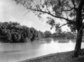
Longreach, 1938
-
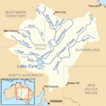
Map of the Lake Eyre Basin showing Thomson River
See also
 You can also find information about the Thomson River for kids in Spanish: Río Thomson para niños
