Prairie, Queensland facts for kids
Quick facts for kids PrairieQueensland |
|||||||||||||||
|---|---|---|---|---|---|---|---|---|---|---|---|---|---|---|---|

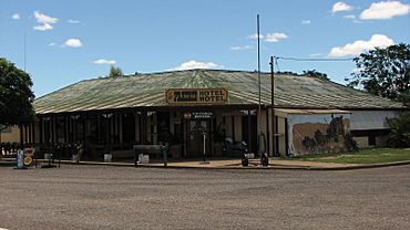
Prairie Hotel Motel
|
|||||||||||||||
| Population | 116 (2021 census) | ||||||||||||||
| • Density | 0.01395/km2 (0.0361/sq mi) | ||||||||||||||
| Postcode(s) | 4821 | ||||||||||||||
| Area | 8,318.3 km2 (3,211.7 sq mi) | ||||||||||||||
| Time zone | AEST (UTC+10:00) | ||||||||||||||
| Location |
|
||||||||||||||
| LGA(s) | Shire of Flinders | ||||||||||||||
| State electorate(s) | Traeger | ||||||||||||||
| Federal Division(s) | Kennedy | ||||||||||||||
|
|||||||||||||||
Prairie is a small rural town in Queensland, Australia. It is part of the Flinders Shire. In 2021, about 116 people lived in Prairie.
Contents
Where is Prairie Located?
Prairie is in the northern part of its local area. The Flinders Highway is a main road that goes right through the town. It connects Prairie to places like Torrens Creek and Hughenden.
Railway Lines and Stations
A railway line, called the Great Northern, runs next to the highway. There are several railway stations along this line, from east to west:
- Warreah railway station (20°49′41″S 144°48′09″E / 20.8280°S 144.8026°E)
- Karoon railway station (no longer used) (20°50′43″S 144°43′33″E / 20.8453°S 144.7258°E)
- Prairie railway station, which serves the town (20°52′18″S 144°36′03″E / 20.8717°S 144.6009°E)
- Baronta railway station (no longer used) (20°52′40″S 144°31′03″E / 20.8778°S 144.5175°E)
- Tolkuru railway station (no longer used) (20°52′33″S 144°27′13″E / 20.8757°S 144.4535°E)
- Tindo railway station (20°52′19″S 144°25′00″E / 20.8719°S 144.4166°E)
- Jardine Valley railway station (no longer used) (20°52′10″S 144°23′25″E / 20.8694°S 144.3902°E)
A Look at Prairie's Past
The name Prairie comes from a large farm, or pastoral station, that was set up by James Gilson. He named it because the land looked like a prairie, which means a large, flat grassland.
Prairie State School first opened its doors in 1894.
Population Changes in Prairie
The number of people living in Prairie has changed over the years:
- In 2006, about 103 people lived in Prairie and the nearby areas.
- By 2016, the population of Prairie grew to 143 people.
- In the most recent count in 2021, about 116 people lived in Prairie.
Learning in Prairie
Prairie State School is a primary school for students from Prep to Year 6. It is located on Savage Street (20°52′15″S 144°36′19″E / 20.8707°S 144.6053°E). In 2018, the school had 7 students and 1 teacher.
There isn't a high school in Prairie itself. Students who want to continue their education usually go to Hughenden State School. This school is in the nearby town of Hughenden.
For students living far away in the southern part of Prairie, attending a daily school might be difficult. In these cases, students might learn through distance education (learning from home) or go to a boarding school.
What Prairie Offers
The town of Prairie has a few useful places for its residents and visitors. You can find a hotel and motel, which also has a pub. There is also a cafe that doubles as a post office.
 | Bayard Rustin |
 | Jeannette Carter |
 | Jeremiah A. Brown |


