Corfield, Queensland facts for kids
Quick facts for kids CorfieldQueensland |
|||||||||||||||
|---|---|---|---|---|---|---|---|---|---|---|---|---|---|---|---|

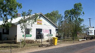
The historic Corfield Pub. A sign promoting the Corfield Cup can also be seen.
|
|||||||||||||||
| Population | 158 (2021 census) | ||||||||||||||
| Postcode(s) | 4733 | ||||||||||||||
| Location |
|
||||||||||||||
| LGA(s) | Shire of Winton | ||||||||||||||
| State electorate(s) | Gregory | ||||||||||||||
| Federal Division(s) | Maranoa | ||||||||||||||
|
|||||||||||||||
Corfield is a small town in north-western Queensland, Australia. It is part of the Shire of Winton. In 2021, about 158 people lived in the Corfield area.
Contents
Where is Corfield?
Corfield is located in a remote part of Queensland. It is about 1,438 kilometers (893 miles) north-west of Brisbane, the state capital. The town sits on the Kennedy Developmental Road. This road connects Winton and Hughenden.
The Landsborough Highway also goes through the Corfield area. It joins the Kennedy Developmental Road near Winton. A railway line, the Central Western railway line, passes through the southern part of Corfield. It ends at the Winton railway station.
Most of the land around Corfield is used for raising cattle.
Corfield's connection to Winton
Even though Corfield is its own town, some of Winton's facilities are actually in Corfield. These include the Winton Golf Course. The Winton Showground and Racecourse are also located here.
Winton uses water from the Great Artesian Basin. This water comes out of the ground very hot, between 83 to 86 degrees Celsius (181 to 187 degrees Fahrenheit). It is cooled down in ponds in Corfield to 44 degrees Celsius (111 degrees Fahrenheit). After cooling, the water is sent to Winton for use.
A Look Back: Corfield's History
First Peoples of the Land
The Jirandali people are the traditional owners of this land. Their language area includes places like Hughenden, Richmond, and Winton. It also includes Corfield.
From Manuka to Corfield
Corfield started as a changing station for Cobb & Co coaches. These coaches carried mail between Hughenden and Winton. Back then, it was called Manuka, named after a nearby sheep farm.
In 1899, a railway line was built to connect Hughenden and Winton. The town of Manuka was moved about 1 kilometer (0.6 miles) west to be closer to the new railway. It was then renamed Corfield. The new name honored William Henry Corfield. He was a local businessman and politician. He worked hard to get the railway built.
At its busiest, Corfield had about 30 to 40 residents. It had railway houses, a post office, and a hotel. There was also a school and a goods shed.
Important Dates
- 1898: The Corfield Post Office opened. It closed in 1991.
- 1957: Corfield State School first opened on February 4.
- 1975: The school closed on January 31.
- 1976: It reopened on January 27.
- 1989: The school closed again on December 15.
People Living in Corfield
The number of people living in the Corfield area has changed over the years:
- 2006: 162 people
- 2011: 380 people
- 2016: 183 people
- 2021: 158 people
By 2012, only about seven people lived permanently in the town itself.
Learning in Corfield
There are no schools in Corfield today. The closest government school is Winton State School. It is in Winton, to the south-west. This school teaches students from Prep (kindergarten) to Year 12. However, it can be too far for some students in Corfield to attend daily.
Other options for students include distance education. This means learning from home with lessons sent to you. Some students also go to boarding school.
What's in Corfield?
The main community building in Corfield is the Corfield Pub. It serves as a central meeting place for locals.
Fun Events
The biggest social event in Corfield is the Corfield Cup horse race. This exciting race happens in early August. It's a fun play on the name of the famous Caulfield Cup horse race held in Melbourne.
 | Dorothy Vaughan |
 | Charles Henry Turner |
 | Hildrus Poindexter |
 | Henry Cecil McBay |


