Stamford, Queensland facts for kids
Quick facts for kids StamfordQueensland |
|||||||||||||||
|---|---|---|---|---|---|---|---|---|---|---|---|---|---|---|---|

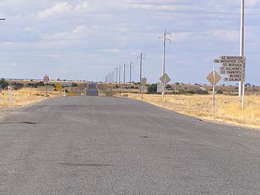
The Kennedy Developmental Road seen at Stamford Roadhouse
|
|||||||||||||||
| Population | 77 (2021 census) | ||||||||||||||
| • Density | 0.01145/km2 (0.0297/sq mi) | ||||||||||||||
| Postcode(s) | 4821 | ||||||||||||||
| Area | 6,724.8 km2 (2,596.5 sq mi) | ||||||||||||||
| Time zone | AEST (UTC+10:00) | ||||||||||||||
| Location |
|
||||||||||||||
| LGA(s) | Shire of Flinders | ||||||||||||||
| State electorate(s) | Traeger | ||||||||||||||
| Federal Division(s) | Kennedy | ||||||||||||||
|
|||||||||||||||
Stamford is a small rural town in Queensland, Australia. It's part of the Shire of Flinders. In 2021, about 77 people lived in the Stamford area. It's a quiet place where people mostly raise animals like cattle and sheep.
Contents
Where is Stamford?
Stamford is located in the north-east part of its area. It sits on the Kennedy Developmental Road. This road connects the towns of Hughenden and Winton. Stamford is about 1504 kilometers (935 miles) north-west of Brisbane. Brisbane is the capital city of Queensland. It's also about 446 kilometers (277 miles) west of Townsville. Townsville is a big regional city.
There are also two small areas nearby called Chinbi and Whitewood. These places used to have railway stations. Most of the land around Stamford is used for grazing. This means farmers let their animals, like cattle, eat the natural plants there.
A Look at Stamford's Past
Stamford has an interesting history. It was once a popular stop for the old Cobb & Co coaches. These coaches were like horse-drawn buses. They carried people and mail between Winton and Hughenden a long time ago.
The Railway Story
A railway line, called the Hughenden-Winton railway, reached Stamford in 1897. This was a big deal for the town. It helped people and goods travel more easily. The railway line followed the same path as the Kennedy Developmental Road. There were several railway stations along this line. Some of them were Alba, Waback, Warianna, Chinbi, and Whitewood. The railway officially closed in 2008. The tracks were removed in 2012.
The name Chinbi comes from an Aboriginal word. It means "star."
Schools in Stamford
Stamford has had a few schools over the years.
- Stamford Provisional School opened in 1899. It closed a few years later in 1906.
- Much later, Stamford State School opened in 1984. This school helped educate local children for many years. However, it closed its doors on July 29, 2013.
A Community Hero
In 2003, a special award was given to Mrs. Jean Eva Anderson. She lived near Stamford. She received the Medal of the Order of Australia. This award was for her amazing service to the community. She helped the Hughenden branch of the Queensland Country Women's Association for 52 years! This group helps women and families in rural areas.
Stamford Today
In 2012, Stamford was a very small place. It had a roadhouse, which is like a roadside stop for travelers. Only about 3 people lived there permanently at that time.
Recently, in 2021, a nearby town called Marathon became its own separate area. Before that, it was part of Stamford. This change helped make things clearer for everyone.
Who Lives in Stamford?
The number of people living in Stamford has changed over the years.
- In 2006, about 75 people lived in the Stamford area.
- By 2016, the population was 43 people.
- The most recent count in 2021 showed that 77 people lived in the Stamford area.
Education for Kids
Stamford does not have any schools right now. Children living there usually go to school in nearby towns.
- The closest primary schools are in Hughenden or Tangorin.
- For high school, students can go to Hughenden State School. It teaches students up to Year 12.
- Because Stamford is quite far from other towns, some students might learn through distance education. This means they learn from home using online lessons or mailed materials. Some students might also go to boarding schools.
Fun Events

The Stamford Races are a popular event in the area. People come together to watch horse racing. It's a fun social gathering for the community.
 | Emma Amos |
 | Edward Mitchell Bannister |
 | Larry D. Alexander |
 | Ernie Barnes |


