
Karumba, Queensland facts for kids
Quick facts for kids KarumbaQueensland |
|||||||||||||||
|---|---|---|---|---|---|---|---|---|---|---|---|---|---|---|---|

Karumba Beach Gulf Savannah
|
|||||||||||||||

Karumba
Location in Queensland
|
|||||||||||||||
| Population | 487 (2021 census) | ||||||||||||||
| • Density | 3.560/km2 (9.22/sq mi) | ||||||||||||||
| Postcode(s) | 4891 | ||||||||||||||
| Elevation | 2 m (7 ft) | ||||||||||||||
| Area | 136.8 km2 (52.8 sq mi) | ||||||||||||||
| Time zone | AEST (UTC+10:00) | ||||||||||||||
| Location |
|
||||||||||||||
| LGA(s) | Shire of Carpentaria | ||||||||||||||
| State electorate(s) | Traeger | ||||||||||||||
| Federal Division(s) | Kennedy | ||||||||||||||
|
|||||||||||||||
|
|||||||||||||||
Karumba is a small town located right on the coast in Queensland, Australia. It's part of the Shire of Carpentaria and is known for being the only town along the southern Gulf of Carpentaria that you can see the Gulf from. In 2021, about 487 people lived here.
Contents
Where is Karumba Located?
Karumba is in the Gulf Country region of Queensland. It's about 71 kilometers (44 miles) by road from Normanton. The state capital, Brisbane, is much further away, about 2,159 kilometers (1,342 miles).
The town sits at the mouth of the Norman River. This special spot means it has great views of the Gulf. The area is also famous for a rare weather event. Sometimes, in September and October, a huge, long cloud called the Morning Glory cloud rolls through early in the morning.
Karumba Point Beach is the only beach in the area you can reach by a paved road. It's super popular for watching amazing sunsets over the Gulf of Carpentaria.
Karumba Airport is on Fielding Street. It doesn't have regular flights. The closest airport with regular services is Normanton Airport.
Karumba's Past: A Glimpse into History
For thousands of years before Europeans arrived, the Karumba area was home to the Gangalidda and Waanyi peoples. They were the traditional owners of this land. They lived off the rich sea life and fertile coastal plains.
The settlement was first called Norman Mouth or Kimberley. The name Karumba comes from an Aboriginal name for the area. This name became official for the town by the 1880s.
The Karumba Post Office opened in 1889 but closed in 1919.
Because it's right on the Gulf of Carpentaria, fishing has always been a big part of Karumba's economy. The prawn fishing industry really grew in the 1960s.
In the late 1930s, Karumba was an important stop for flying boats. These planes, operated by Qantas Empire Airways, would refuel and get maintenance here. During World War II, No. 43 Squadron of the RAAF also used Karumba. They flew Consolidated PBY Catalina flying boats from the town between 1943 and 1944.
Karumba State School opened its doors in September 1968.
The local Community Church holds regular services by the Uniting Church in Australia. These services are provided by the McKay Patrol. This is an aerial service that flies out of Cloncurry. The McKay Patrol uses a Cessna 182Q airplane. They provide spiritual and practical help to people living in remote areas. This includes parts of north-west Queensland and the Eastern Tablelands of the Northern Territory. This huge area is about 625,000 square kilometers (241,000 sq mi) but has less than 10,000 people.
Karumba Public Library first opened in 1979.
Karumba is even mentioned in songs! The Australian band Goanna refers to the region in their song "Every Passing Day." The Red Hot Chili Peppers also have a song called "Animal Bar" about Karumba. It's on their 2006 album Stadium Arcadium and talks about a local bar.
What is Karumba's Economy Like?
The port in Karumba is important for the Century Zinc Mine. It also supports the town's big fishing industry.
The Les Wilson Barramundi Hatchery is located here. It's the only place in the world that breeds the Southern Gulf barramundi.
The prawning industry is a very important part of the town's economy.
Education in Karumba
Karumba State School is a government primary school for students from Prep to Year 6. It's located at 5 Yappar Street. In 2018, the school had 28 students.
There are no secondary schools in Karumba itself. The closest government secondary school is Normanton State School. It goes up to Year 10 and is in nearby Normanton. For students needing to complete Years 11 and 12, options include distance education or boarding school.
Community Life and Services
Karumba has many great facilities for its residents and visitors. These include a public library on Walker Street and a visitor information center. There are also parks, a bowls club, a golf course, a swimming pool, and a sports center.
The Carpentaria Shire Council manages the public library.
St James' and St John's Community Church is a shared church. It's used by Anglican, Catholic, and Uniting congregations.
The McKay Patrol, an aerial service of the Uniting Church in Australia, provides regular church services. They fly from Cloncurry to help people in remote areas.
Fun Things to Do in Karumba
The Les Wilson Barramundi Discovery Centre is a popular spot. It's at 149 Yappar Street. Here, you can have interactive experiences and learn all about barramundi. It's also a working barramundi hatchery!
Karumba's Climate
Karumba has a tropical savanna climate. This means it has two main seasons.
The "Wet" usually runs from December to March. It's hot and humid, with high temperatures. Heavy rain often closes roads during this time. Sometimes, a tropical cyclone or monsoonal depression can bring over 250 mm (10 inches) of rain in a single day!
The ""Dry" usually lasts from April to mid-November. This season is much more comfortable. It has lower humidity and cooler mornings. It's also very dry, with almost no clouds. From May to September, there's usually no rain at all.
| Climate data for Karumba, Queensland (1938-2012) | |||||||||||||
|---|---|---|---|---|---|---|---|---|---|---|---|---|---|
| Month | Jan | Feb | Mar | Apr | May | Jun | Jul | Aug | Sep | Oct | Nov | Dec | Year |
| Record high °C (°F) | 39.8 (103.6) |
37.6 (99.7) |
38.4 (101.1) |
38.9 (102.0) |
34.5 (94.1) |
32.8 (91.0) |
32.4 (90.3) |
35.4 (95.7) |
36.9 (98.4) |
40.4 (104.7) |
40.7 (105.3) |
41.3 (106.3) |
41.3 (106.3) |
| Mean daily maximum °C (°F) | 32.1 (89.8) |
31.7 (89.1) |
32.5 (90.5) |
32.6 (90.7) |
29.8 (85.6) |
27.9 (82.2) |
27.5 (81.5) |
28.6 (83.5) |
29.9 (85.8) |
31.3 (88.3) |
32.6 (90.7) |
32.4 (90.3) |
30.7 (87.3) |
| Mean daily minimum °C (°F) | 24.4 (75.9) |
24.1 (75.4) |
23.2 (73.8) |
20.7 (69.3) |
17.2 (63.0) |
15.2 (59.4) |
14.0 (57.2) |
15.2 (59.4) |
18.2 (64.8) |
21.0 (69.8) |
23.3 (73.9) |
24.4 (75.9) |
20.1 (68.2) |
| Record low °C (°F) | 19.6 (67.3) |
18.3 (64.9) |
18.0 (64.4) |
13.6 (56.5) |
8.0 (46.4) |
6.9 (44.4) |
6.1 (43.0) |
5.3 (41.5) |
10.6 (51.1) |
12.2 (54.0) |
17.8 (64.0) |
17.9 (64.2) |
5.3 (41.5) |
| Average rainfall mm (inches) | 231.0 (9.09) |
260.3 (10.25) |
156.6 (6.17) |
30.3 (1.19) |
1.0 (0.04) |
8.5 (0.33) |
7.1 (0.28) |
2.0 (0.08) |
1.6 (0.06) |
7.3 (0.29) |
45.5 (1.79) |
142.1 (5.59) |
893.3 (35.16) |
| Average rainy days (≥ 0.2 mm) | 12.7 | 14.7 | 9.3 | 2.8 | 0.4 | 1.0 | 0.6 | 0.4 | 0.4 | 0.9 | 4.2 | 8.9 | 56.3 |
| Source: Australian Bureau of Meteorology | |||||||||||||
Images for kids
-
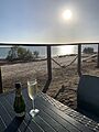
Sunset over the Gulf of Carpentaria at Karumba Beach
-
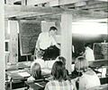
Karumba State School, around 1970


